- Australia ▾
- Topographic
▾
- Australia AUSTopo 250k (2025)
- Australia 50k Geoscience maps
- Australia 100k Geoscience maps
- Australia 250k Geoscience maps
- Australia 1:1m Geoscience maps
- New Zealand 50k maps
- New Zealand 250k maps
- New South Wales 25k maps
- New South Wales 50k maps
- New South Wales 100k maps
- Queensland 10k maps
- Queensland 25k maps
- Queensland 50k maps
- Queensland 100k maps
- Western Australia 25k maps
- Western Australia 50k maps
- Western Australia 100k maps
- Compasses
- Software
- GPS Systems
- International ▾
- Wall Maps
▾
- World
- Australia & New Zealand
- Countries, Continents & Regions
- Historical
- Vintage National Geographic
- Australian Capital Territory
- New South Wales
- Northern Territory
- Queensland
- South Australia
- Tasmania
- Victoria
- Western Australia
- Celestial
- Children's
- Mining & Resources
- Wine Maps
- Healthcare
- Postcode Maps
- Electoral Maps
- Nautical ▾
- Flags
▾
- Australian Flag Sets & Banners
- Flag Bunting
- Handwavers
- Australian National Flags
- Aboriginal Flags
- Torres Strait Islander Flags
- International Flags
- Flagpoles & Accessories
- Australian Capital Territory Flags
- New South Wales Flags
- Northern Territory Flags
- Queensland Flags
- South Australia Flags
- Tasmania Flags
- Victoria Flags
- Western Australia Flags
- Gifts ▾
- Globes ▾
Dear valued customer. Please note that our checkout is not supported by old browsers. Please use a recent browser to access all checkout capabilities


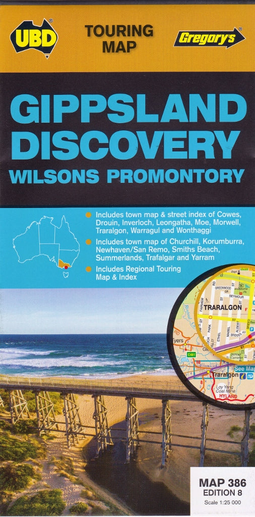
Gippsland Discovery & Wilsons Promontory UBD 386 Map
$12.95
Afterpay is only available for orders between $50.00 and $1000.00 More info
Regional Touring Map | Town Maps & Street Indexes | Ideal for Road Trips & Getaways
Scale: 1:25,000 | Size: 700 mm (W) x 1000 mm (H)
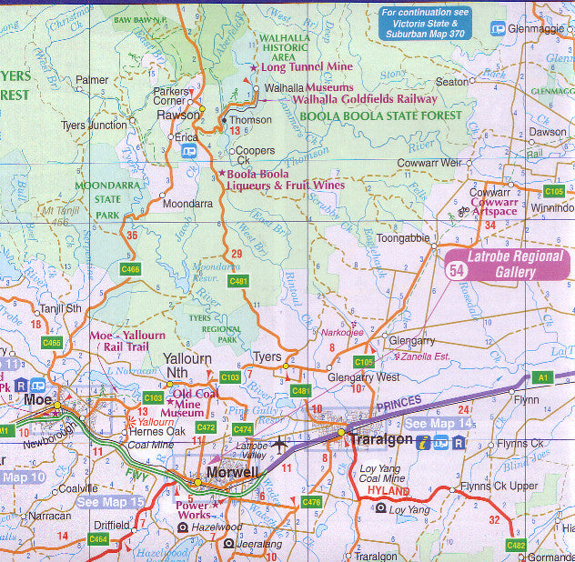
Explore the beauty of coastal Victoria and the diverse landscapes of Gippsland and Wilsons Promontory with this expertly crafted touring map by UBD Gregory’s. Designed for road-trippers, weekend adventurers, and holidaymakers, this map delivers a detailed and highly practical view of both regional road networks and local towns.
Covering a wide sweep of eastern Victoria, this map is the ideal companion for those travelling between beaches, forests, lakes, and charming country towns—from the Latrobe Valley to the Prom.
🧭 Key Features
| ✅ Feature | 📍 Description |
|---|---|
| 🗺️ Main Touring Region | Covers Gippsland’s major roads, tourist routes, and coastal access to Wilsons Promontory |
| 🏙️ Detailed Town Maps | Street-level maps of: Moe, Morwell, Sale, Traralgon, Warragul |
| 🗺️ Additional Town Coverage | Includes local town maps of: Churchill, Drouin, Heyfield, Inverloch, Korumburra, Leongatha, Maffra, Rosedale, Trafalgar, Wonthaggi, and Yarram |
| 🏞️ Wilsons Promontory Access | Road approach, key facilities, and travel planning around Victoria’s beloved national park |
| 📍 Touring Attractions List | Includes highlights such as scenic lookouts, coastal drives, national parks, and cultural stops |
| 🏪 Local Business Information | Handy for finding accommodation, services, cafes, and visitor centres in mapped towns |
| 📚 Street Indexes | Quick-reference indexes for fast navigation across main towns and regional hubs |
🚗 Who Is This Map For?
This map is ideal for:
-
🚙 Road trippers exploring Gippsland’s beaches, lakes, and rural towns
-
🏕️ Campers and caravaners headed to Wilsons Prom, Ninety Mile Beach, or Tarra-Bulga National Park
-
🏞️ National Park visitors looking to explore trails, coastlines, and native wildlife
-
📚 Students or teachers needing a regional overview for educational purposes
-
🧳 Families on holiday planning day trips, sightseeing, and accommodation routes
-
🗂️ Small businesses and delivery drivers requiring an accurate local street map reference
📐 Product Specifications
| Specification | Detail |
|---|---|
| Publisher | UBD Gregory's |
| Map Number | 386 |
| Title | Gippsland Discovery & Wilsons Promontory Touring Map |
| Scale | 1:25,000 |
| Size (flat) | 700 mm (W) × 1000 mm (H) |
| Format | Folded paper touring map |
| Material | Durable, full-colour map stock |
| Printed in | Australia |
🌿 Your Companion to Victoria’s Eastern Wonders
From the alpine foothills to the windswept coastal headlands, Gippsland and Wilsons Promontory offer a diverse mix of nature, history, and hospitality. With this touring map in hand, you'll have everything you need to:
-
Trace the rail trails and river routes through lush countryside
-
Navigate to hidden beaches, wetlands, and forest parks
-
Discover charming regional towns and their local secrets
-
Plan stress-free detours to scenic spots, picnic areas, and farmgates
🛒 Add to Cart Today – Plan your journey to one of Victoria’s most cherished regions with clarity and confidence.
Frequently Asked Questions
Where can I buy the Gippsland Discovery & Wilsons Promontory UBD 386 Map?
The Gippsland Discovery & Wilsons Promontory UBD 386 Map is available to buy online from Mapworld, Australia's largest map and geographic product retailer, with fast shipping Australia-wide.
Is the Gippsland Discovery & Wilsons Promontory UBD 386 Map in stock at Mapworld?
Mapworld maintains extensive stock across its map range and aims for fast dispatch. Orders placed before 2pm AEST on business days are typically dispatched the same day, with standard and express Australia-wide delivery options available.
What is Mapworld's returns policy?
Mapworld accepts returns on undamaged items in original condition. Contact Mapworld within 90 days of purchase to arrange a return or exchange.
Does Mapworld ship the Gippsland Discovery & Wilsons Promontory UBD 386 Map across Australia?
Yes, Mapworld ships Australia-wide. Standard shipping is a flat $7 rate, with free standard shipping on orders over $75. Express options are available at checkout. Most orders placed before 2pm AEST on weekdays are dispatched same day.
Related Items


© 2026 Mapworld. Website designed by Genie Media
X