- Australia ▾
- Topographic
▾
- Australia AUSTopo 250k (2025)
- Australia 50k Geoscience maps
- Australia 100k Geoscience maps
- Australia 250k Geoscience maps
- Australia 1:1m Geoscience maps
- New Zealand 50k maps
- New Zealand 250k maps
- New South Wales 25k maps
- New South Wales 50k maps
- New South Wales 100k maps
- Queensland 10k maps
- Queensland 25k maps
- Queensland 50k maps
- Queensland 100k maps
- Western Australia 25k maps
- Western Australia 50k maps
- Western Australia 100k maps
- Compasses
- Software
- GPS Systems
- International ▾
- Wall Maps
▾
- World
- Australia & New Zealand
- Countries, Continents & Regions
- Historical
- Vintage National Geographic
- Australian Capital Territory
- New South Wales
- Northern Territory
- Queensland
- South Australia
- Tasmania
- Victoria
- Western Australia
- Celestial
- Children's
- Mining & Resources
- Wine Maps
- Healthcare
- Postcode Maps
- Electoral Maps
- Nautical ▾
- Flags
▾
- Australian Flag Sets & Banners
- Flag Bunting
- Handwavers
- Australian National Flags
- Aboriginal Flags
- Torres Strait Islander Flags
- International Flags
- Flagpoles & Accessories
- Australian Capital Territory Flags
- New South Wales Flags
- Northern Territory Flags
- Queensland Flags
- South Australia Flags
- Tasmania Flags
- Victoria Flags
- Western Australia Flags
- Gifts ▾
- Globes ▾
Dear valued customer. Please note that our checkout is not supported by old browsers. Please use a recent browser to access all checkout capabilities


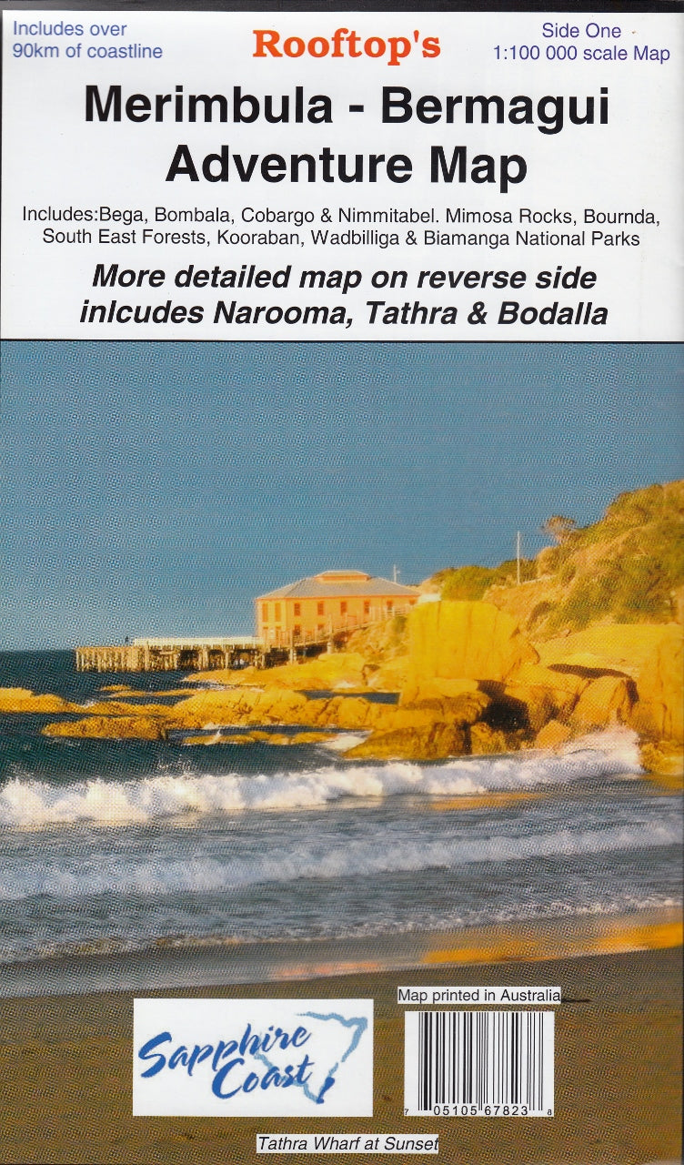
Merimbula-Bermagui Adventure Map Rooftop
Sold Out
Afterpay is only available for orders between $50.00 and $1000.00 More info
Scale: 1:100,000 | Bonus Enlargement: 1:50,000
Publisher: Rooftop Maps | Format: Folded (Laminated Optional)
🏞️ Explore the Sapphire Coast and Beyond in Detail
Discover the wild beauty and rich diversity of the far south coast of New South Wales with the Merimbula–Bermagui Adventure Map by Rooftop. This topographic touring map covers a vast and scenic sweep of countryside—from lush hinterlands and historic townships to pristine beaches, forest trails, and secluded coastal lakes.
Whether you’re a seasoned 4WD explorer, a beachcomber, a bushwalker, or a nature photographer, this map is your essential guide to the region’s best-kept secrets.
📍 Coverage Includes:
-
Major Towns & Villages: Merimbula, Bermagui, Bega, Narooma, Cobargo, Bemboka, Bombala
-
Coastal and Hinterland Highlights: Wallaga Lake, Mystery Bay, Tilba, Bournda, Tathra, Cathcart, Wyndham, Bodalla
-
National Parks & Forests: Biamanga National Park, Bournda National Park, Wadbilliga Wilderness
-
Estuaries, Rivers & Lakes: Bega River, Wallaga Lake, Wapengo Lagoon, and more
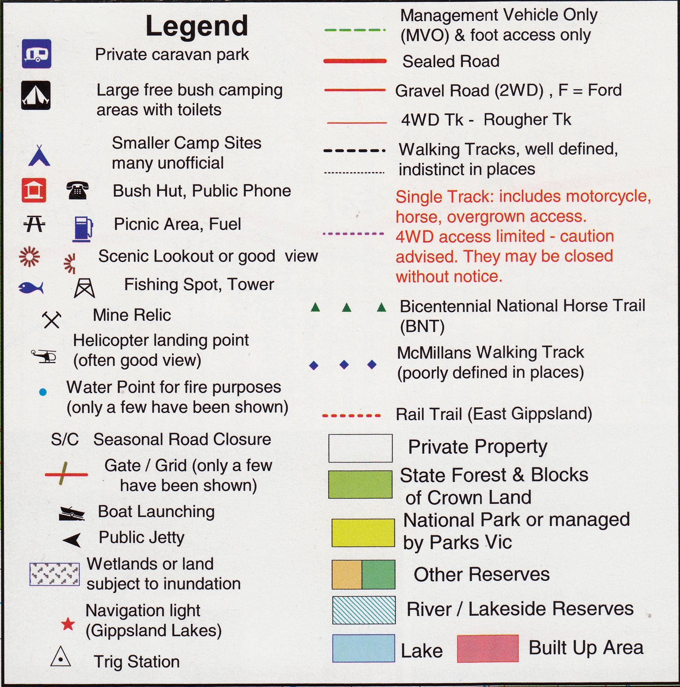
🧭 What’s Shown on the Map?
-
Walking tracks and hiking trails
-
4WD vehicle access tracks
-
Main and secondary roads
-
Navigation markers and jetties
-
Beach access points and boat ramps
-
Estuaries, creeks, rivers, and watercourses
-
Campsites, lookouts, picnic areas, and natural features of interest
🔍 Reverse Side Bonus Map
Included on the reverse is a high-detail enlargement at 1:50,000 scale, titled:
Tathra–Narooma Forest Activities Map
This section is perfect for more intricate planning, showcasing walking trails, 4WD tracks, campsites, and hidden forest gems across this dense coastal corridor.
♻️ Optional Lamination for Durability
We offer an optional laminated version of this map, which is:
-
Water-resistant and tear-resistant
-
Ideal for drawing temporary notes with whiteboard markers
-
Compatible with Map Dots for marking locations of interest
-
Long-lasting and perfect for repeated field use in all weather
Note: Laminated versions are made by flattening the folded map and encapsulating it in crystal-clear 80-micron laminate. Fold lines may remain faintly visible.
📐 Map Specifications
| Feature | Details |
|---|---|
| Main Map Scale | 1:100,000 |
| Reverse Enlargement | 1:50,000 |
| Format | Folded map (laminated optional) |
| Map Size (open) | Approx. 690 mm × 1000 mm |
| Publisher | Rooftop Maps, Australia |
🏕️ Ideal For:
✔️ Outdoor enthusiasts and 4WD adventurers
✔️ Bushwalkers and coastal explorers
✔️ Tourists seeking off-the-beaten-path beauty
✔️ Locals wanting to rediscover their own backyard
✔️ A thoughtful gift for nature lovers or caravanners
Made in Australia – Designed for exploration.
Plan smarter, wander further, and make your next south coast journey unforgettable.
Frequently Asked Questions
Where can I buy the Merimbula-Bermagui Adventure Map Rooftop?
The Merimbula-Bermagui Adventure Map Rooftop is available to buy online from Mapworld, Australia's largest map and geographic product retailer, with fast shipping Australia-wide.
Is the Merimbula-Bermagui Adventure Map Rooftop in stock at Mapworld?
Mapworld maintains extensive stock across its map range and aims for fast dispatch. Orders placed before 2pm AEST on business days are typically dispatched the same day, with standard and express Australia-wide delivery options available.
What is Mapworld's returns policy?
Mapworld accepts returns on undamaged items in original condition. Contact Mapworld within 90 days of purchase to arrange a return or exchange.
Does Mapworld ship the Merimbula-Bermagui Adventure Map Rooftop across Australia?
Yes, Mapworld ships Australia-wide. Standard shipping is a flat $7 rate, with free standard shipping on orders over $75. Express options are available at checkout. Most orders placed before 2pm AEST on weekdays are dispatched same day.
Related Items


© 2026 Mapworld. Website designed by Genie Media
X