- Australia ▾
- Topographic
▾
- Australia AUSTopo 250k (2024)
- Australia 50k Geoscience maps
- Australia 100k Geoscience maps
- Australia 250k Geoscience maps
- Australia 1.1m Geoscience maps
- New Zealand 50k maps
- New Zealand 250k maps
- New South Wales 25k maps
- New South Wales 50k maps
- New South Wales 100k maps
- Queensland 10k maps
- Queensland 25k maps
- Queensland 50k maps
- Queensland 100k maps
- Compasses
- Software
- GPS Systems
- Orienteering
- International ▾
- Wall Maps
▾
- World
- Australia & New Zealand
- Countries, Continents & Regions
- Historical
- Vintage National Geographic
- Australian Capital Territory
- New South Wales
- Northern Territory
- Queensland
- South Australia
- Tasmania
- Victoria
- Western Australia
- Celestial
- Children's
- Mining & Resources
- Wine Maps
- Healthcare
- Postcode Maps
- Electoral Maps
- Nautical ▾
- Flags
▾
- Australian Flag Sets & Banners
- Flag Bunting
- Handwavers
- Australian National Flags
- Aboriginal Flags
- Torres Strait Islander Flags
- International Flags
- Flagpoles & Accessories
- Australian Capital Territory Flags
- New South Wales Flags
- Northern Territory Flags
- Queensland Flags
- South Australia Flags
- Tasmania Flags
- Victoria Flags
- Western Australia Flags
- Gifts ▾
- Globes ▾
Dear valued customer. Please note that our checkout is not supported by old browsers. Please use a recent browser to access all checkout capabilities
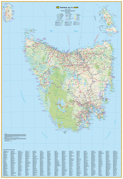
Tasmania UBD 770 Map 1380 x 2000mm Laminated Wall Map
$549.00
or make 4 interest-free payments of
$137.25 AUD
fortnightly with
![]() More info
More info
Format: Laminated (Flat, Ships Rolled)
Size: 1400 mm (W) × 2000 mm (H)
Publisher: UBD Gregory’s
Made in Australia 🇦🇺
🌄 Explore Tasmania in Stunning Detail
Spanning nearly two metres in height, the Tasmania UBD 770 Wall Map is your complete visual guide to the Apple Isle. Whether you’re planning logistics across rugged terrain, marking tourist destinations, or teaching the next generation about geography, this high-quality laminated map offers unparalleled clarity and durability.
Published by UBD Gregory’s, Australia’s most trusted cartographic authority, this map covers the entire state of Tasmania — from the remote beauty of the Tarkine and the Central Highlands, to the coastlines of Bruny Island and the urban complexity of Hobart and Launceston.
This is not just a map — it's a planning tool, a teaching resource, and a statement piece for any professional environment.
🔍 Map Features
📌 Major & Minor Roads
Clearly marked roadways including dual carriageways, sealed highways, and secondary regional roads — ideal for logistics, travel planning, and fieldwork navigation.
🏘️ Fully Indexed Towns
Includes a detailed index of all regional towns, suburbs, and communities, making it fast and easy to locate even the smallest settlements.
🌳 Parks & Protected Areas
Highlights national parks, nature reserves, and conservation lands. Perfect for environmental education, tourism operators, or land management teams.
🗺️ Statewide Clarity
Offers complete visual coverage of Tasmania with legible fonts, intuitive colour coding, and clean layout — helping users of all ages and backgrounds absorb information quickly.
📐 True Large Format
At 1400 mm wide by 2000 mm high, this is a command centre-sized map — ideal for use in offices, schools, government departments, and travel hubs.
🛡️ Encapsulated Gloss Lamination – Built to Last
This map is professionally laminated with 80-micron gloss film, making it highly durable, wipeable, and long-lasting:
🖍️ Whiteboard Marker Compatible
Draw directly onto the map with whiteboard markers to plot routes, highlight regions, or brainstorm strategies. Wipe clean with no residue.
📍 Map Dot Ready
Use adhesive dots or stickers to mark customer locations, project sites, or teaching points — and remove them without leaving damage.
💧 Spill-Resistant, Tear-Proof, UV-Protected
Ideal for environments where the map will be used frequently — from busy planning offices to outdoor education rooms.
📦 Flat Format – Ships Rolled
Delivered rolled in a sturdy tube, this map arrives crease-free and ready to pin, mount, frame, or hang.
👥 Who This Map Is For
This is not a generic wall decoration — it’s a purpose-built tool for professionals, educators, and explorers who need real-world functionality in an easy-to-use format.
🏛️ Local Government & Planners
Use for community outreach, infrastructure development, and jurisdictional clarity across Tasmania.
🚛 Fleet & Logistics Operators
Perfect for delivery networks, route planning, and coordinating services across regional hubs and rural zones.
🎓 Schools & TAFEs
Bring Tasmania’s geography to life in the classroom. Ideal for geography, history, civics, or environmental studies.
🌿 Land Management & Environmental Agencies
Track protected areas, fire zones, and land use boundaries at a glance.
🧳 Tourism Operators & Travel Planners
Highlight routes, attractions, and local services for guests, agents, or internal planning.
📍 Regional Businesses & Franchises
Visualise service territories, pinpoint customer concentrations, and plan for future growth.
📐 Product Specifications
| Feature | Description |
|---|---|
| Publisher | UBD Gregory’s |
| Coverage | Entire state of Tasmania |
| Indexed | Yes – Fully indexed towns and suburbs |
| Road Detail | Major highways, dual carriageways, minor roads |
| Parks & Reserves | Clearly marked with intuitive colour shading |
| Finish | Gloss laminated (whiteboard & map-dot safe) |
| Format | Flat (Ships rolled in tube) |
| Map Size | 1400 mm (W) × 2000 mm (H) |
| Made In | Australia 🇦🇺 |
🚚 Delivery Information
-
Made to Order – Please allow 7–10 business days for preparation and dispatch
-
Ships Rolled in a reinforced tube to protect edges and prevent creasing during transit
-
Mounting Tips included for hanging or pinning
🧭 Turn Any Wall into a Window on Tasmania
This Tasmania UBD 770 Laminated Wall Map is more than just informative — it's functional, interactive, and visually striking. Perfect for those who rely on geography every day, it brings Tasmania’s complex road network and unique natural heritage into clear focus.
📍 Plan. Teach. Navigate. Inspire.
🛒 Order yours today and put Tasmania at the centre of your strategy, classroom, or conversation.


