- Australia ▾
- Topographic
▾
- Australia AUSTopo 250k (2025)
- Australia 50k Geoscience maps
- Australia 100k Geoscience maps
- Australia 250k Geoscience maps
- Australia 1:1m Geoscience maps
- New Zealand 50k maps
- New Zealand 250k maps
- New South Wales 25k maps
- New South Wales 50k maps
- New South Wales 100k maps
- Queensland 10k maps
- Queensland 25k maps
- Queensland 50k maps
- Queensland 100k maps
- Western Australia 25k maps
- Western Australia 50k maps
- Western Australia 100k maps
- Compasses
- Software
- GPS Systems
- International ▾
- Wall Maps
▾
- World
- Australia & New Zealand
- Countries, Continents & Regions
- Historical
- Vintage National Geographic
- Australian Capital Territory
- New South Wales
- Northern Territory
- Queensland
- South Australia
- Tasmania
- Victoria
- Western Australia
- Celestial
- Children's
- Mining & Resources
- Wine Maps
- Healthcare
- Postcode Maps
- Electoral Maps
- Nautical ▾
- Flags
▾
- Australian Flag Sets & Banners
- Flag Bunting
- Handwavers
- Australian National Flags
- Aboriginal Flags
- Torres Strait Islander Flags
- International Flags
- Flagpoles & Accessories
- Australian Capital Territory Flags
- New South Wales Flags
- Northern Territory Flags
- Queensland Flags
- South Australia Flags
- Tasmania Flags
- Victoria Flags
- Western Australia Flags
- Gifts ▾
- Globes ▾
Dear valued customer. Please note that our checkout is not supported by old browsers. Please use a recent browser to access all checkout capabilities


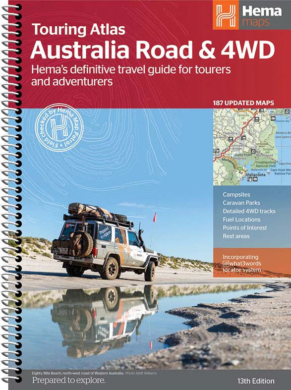
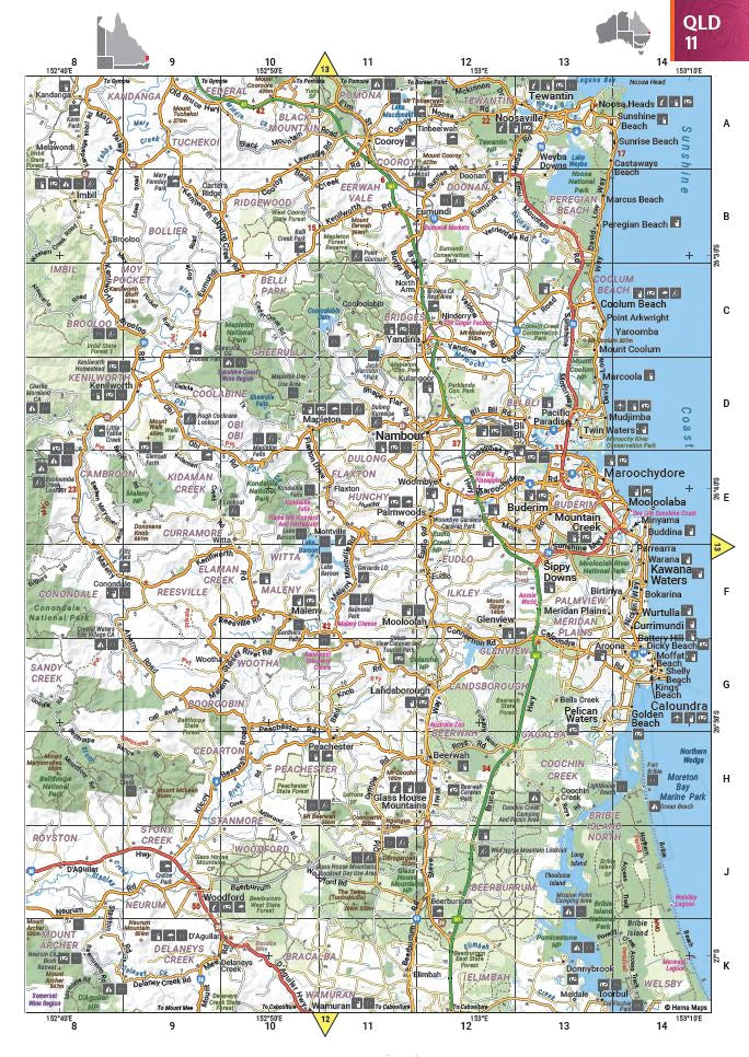
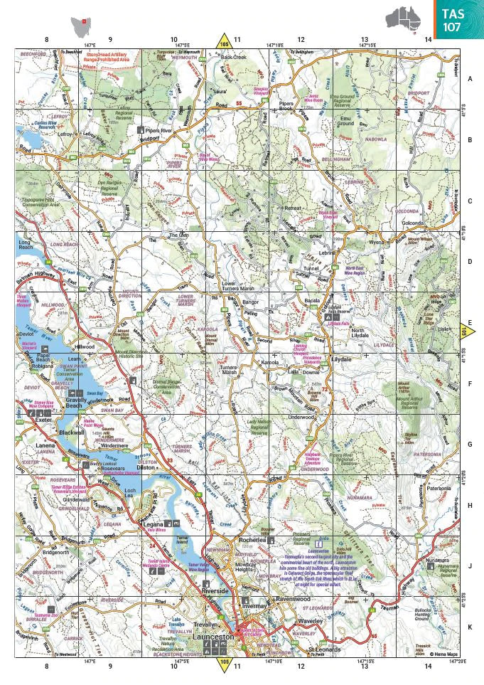
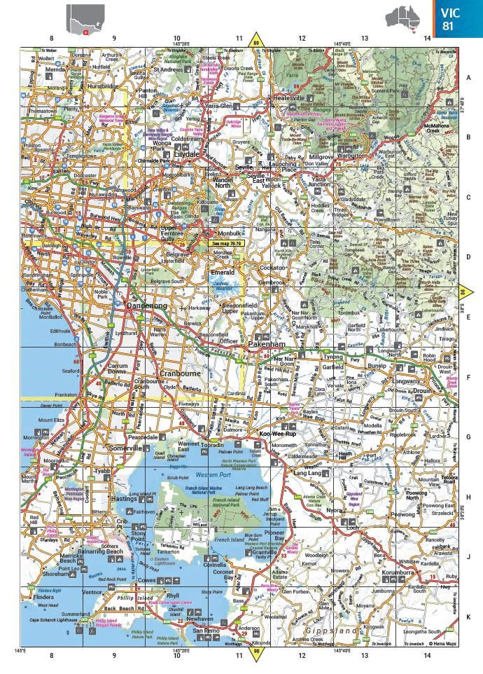
Australia Touring Atlas Spiral Bound New 13th Edition
$44.95
Afterpay is only available for orders between $50.00 and $1000.00 More info
Your Essential Atlas for Road Trips, 4WD Adventures & Off-Grid Exploration Across Australia
Discover Australia with confidence using the Hema Road & 4WD Easy Read Atlas—a comprehensive, user-friendly guide crafted for road trippers, campers, caravanners, and off-road adventurers. With trusted Hema mapping and up-to-date travel insights, this atlas is your go-to reference whether you're sticking to the highways or taking the red-dust detours through Australia’s most remote 4WD regions.
The latest edition includes more maps than ever before, presented in a refreshed cartographic style that is easy on the eyes and perfect for quick navigation on the road. From major highways to rugged tracks, every page is packed with valuable information to support your journey.
What’s Inside?
-
✅ Accurate Hema Mapping Across All of Australia
Featuring fully updated maps with detailed road networks, terrain features, and regional boundaries across every state and territory. -
✅ Dedicated 4WD Coverage
Includes Australia's top 4WD adventure zones, with track info, terrain details, and access guidance for:-
Cape York
-
Fraser Island (K’gari)
-
The Top End
-
The Kimberley
-
The Pilbara
-
Central Australia
-
High Country Victoria
-
Flinders Ranges
-
-
✅ Larger, Easy-to-Read Cartography
A cleaner design with larger fonts, clearer symbols, and intuitive layouts—ideal for navigating while travelling.
🧭 Packed with Travel-Ready Features
This isn’t just a road atlas—it’s a fully-featured touring and trip-planning guide tailored to Australian conditions:
-
✔️ Detailed 4WD Tracks – Includes popular and remote tracks with access notes
-
✔️ Campsites & Rest Areas – Find free and low-cost camping options nationwide
-
✔️ Caravan Parks – Identify accommodation suited to towed vehicles
-
✔️ National Parks – Clearly marked to help you plan nature-based stopovers
-
✔️ Points of Interest – Lookouts, natural features, historic sites, and more
-
✔️ 24-Hour Fuel Stops – Essential for long-distance and off-grid trips
-
✔️ Road Distances & Drive Planning Tools – Accurate driving distances and trip estimations
-
✔️ Distance Grid & National Park Guide – Handy reference tables
-
✔️ List of Accredited Visitor Information Centres – For face-to-face travel support
-
✔️ Fully Indexed – Quickly find towns, roads, regions, and campsites
📏 Product Details
-
Format: Easy Read Atlas
-
Pages: 188 full-colour pages
-
Dimensions: 297mm (H) x 215mm (W)
-
Binding: Durable softcover
-
Weight: Lightweight and easy to store in glove boxes or seat pockets
-
Publisher: Hema Maps – Australia’s most trusted adventure mapping company
🚐 Ideal For:
-
Road trippers and caravanners
-
4WD explorers and overlanders
-
Grey nomads touring the Big Lap
-
Weekend campers and holiday planners
-
Tourers wanting reliable, print-based navigation support
-
Anyone who prefers large-print, easy-to-read maps
Whether you're planning your next road trip, venturing off the beaten track, or looking for a reliable travel companion with detailed campsite and fuel info, the Hema Road & 4WD Easy Read Atlas is the guide trusted by Aussie adventurers year after year.
Frequently Asked Questions
What does the Australia Touring Atlas Spiral Bound New 13th Edition cover?
This atlas covers the geographic region indicated in the product title, including roads, towns, distances, and key travel information. Mapworld stocks atlases for Australian states and territories, 4WD regions, and international destinations.
Is this the latest edition?
Yes, this is the 13th Edition. Mapworld stocks the most current editions available from publishers.
Is this atlas or guide spiral bound?
Spiral binding is indicated in the product title where applicable. Spiral-bound atlases and guides lay flat when open, making them ideal for use in vehicles or on a table without needing to hold pages open.
Is the Australia Touring Atlas Spiral Bound New 13th Edition in stock at Mapworld?
Mapworld maintains extensive stock across its map range and aims for fast dispatch. Orders placed before 2pm AEST on business days are typically dispatched the same day, with standard and express Australia-wide delivery options available.
Does Mapworld ship the Australia Touring Atlas Spiral Bound New 13th Edition across Australia?
Yes, Mapworld ships Australia-wide. Standard shipping is a flat $7 rate, with free standard shipping on orders over $75. Express options are available at checkout. Most orders placed before 2pm AEST on weekdays are dispatched same day.
Related Items

© 2026 Mapworld. Website designed by Genie Media
X