- Australia ▾
- Topographic
▾
- Australia AUSTopo 250k (2025)
- Australia 50k Geoscience maps
- Australia 100k Geoscience maps
- Australia 250k Geoscience maps
- Australia 1:1m Geoscience maps
- New Zealand 50k maps
- New Zealand 250k maps
- New South Wales 25k maps
- New South Wales 50k maps
- New South Wales 100k maps
- Queensland 10k maps
- Queensland 25k maps
- Queensland 50k maps
- Queensland 100k maps
- Compasses
- Software
- GPS Systems
- Orienteering
- International ▾
- Wall Maps
▾
- World
- Australia & New Zealand
- Countries, Continents & Regions
- Historical
- Vintage National Geographic
- Australian Capital Territory
- New South Wales
- Northern Territory
- Queensland
- South Australia
- Tasmania
- Victoria
- Western Australia
- Celestial
- Children's
- Mining & Resources
- Wine Maps
- Healthcare
- Postcode Maps
- Electoral Maps
- Nautical ▾
- Flags
▾
- Australian Flag Sets & Banners
- Flag Bunting
- Handwavers
- Australian National Flags
- Aboriginal Flags
- Torres Strait Islander Flags
- International Flags
- Flagpoles & Accessories
- Australian Capital Territory Flags
- New South Wales Flags
- Northern Territory Flags
- Queensland Flags
- South Australia Flags
- Tasmania Flags
- Victoria Flags
- Western Australia Flags
- Gifts ▾
- Globes ▾
Dear valued customer. Please note that our checkout is not supported by old browsers. Please use a recent browser to access all checkout capabilities
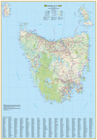
Tasmania Meridian 895 x 1095mm State Wall Map
$79.95
or make 4 interest-free payments of
$19.99 AUD
fortnightly with
![]() More info
More info
A Tribute to the Island State
Discover the heart of Tasmania with this exquisitely detailed state wall map from Meridian Maps—a premium cartographic masterpiece that celebrates the island’s pristine wilderness, winding roads, and vibrant communities. Designed not just as a navigational reference but as a visual homage to Tasmania’s beauty and diversity, this map is an essential piece for adventurers, businesses, educators, and anyone who appreciates the power of place.
Whether you're charting road trips through misty mountain passes, planning logistics across regional centres, or simply admiring the graceful balance of land and sea, this map invites you to explore, reflect, and connect.
🌟 Key Features
🧭 True-to-Scale Statewide Coverage
Covers the entire state of Tasmania at 1:500,000, including:
-
All major cities, towns, and settlements
-
Road networks, highways, and infrastructure
-
King Island and Flinders Island, plus a detailed inset of Macquarie Island—each positioned in geographically accurate locations.
🌳 Public Land Use Shading
Clearly defined shading illustrates:
-
National Parks
-
Conservation Reserves
-
Forests and Public Lands
Perfect for eco-tourism, environmental education, and land-use management.
📍 Points of Interest & Landmarks
Includes:
-
Major tourist destinations
-
Natural attractions and regional highlights
-
Cultural and recreational features like heritage sites, scenic lookouts, and walking trails.
🧠 Intuitive Design & Readability
-
Elegant typography and colour-coding for maximum legibility
-
A clean, modern aesthetic that makes information easy to absorb at a glance
-
Sophisticated yet functional, making it ideal for both display and practical use
🖼️ Available Finishes
Choose a finish that suits your purpose and setting:
| Finish | Description |
|---|---|
| Paper | Printed on 160 gsm high-quality coated paper—perfect for framing under glass or pinboard display. |
| Laminated | Encapsulated in dual 80-micron gloss laminate for durability. Write-on/wipe-off surface ideal for planning or team meetings. |
| Laminated with Hang Rails | Includes elegant natural timber rails and a hanging cord—ready to mount, no frame required. |
| Canvas | Printed on 395 gsm HP Professional Matte Canvas using fade-resistant pigment inks. A striking and tactile surface with exceptional longevity. |
| Canvas with Hang Rails | Arrives ready to hang, with beautifully lacquered wooden battens and top cord—a gallery-worthy feature for your home, studio, or office. |
📐 Specifications
-
Scale: 1:500,000
-
Map Dimensions: 895 mm (W) x 1095 mm (H)
-
Inset: Macquarie Island
-
Publisher: Meridian Maps
-
Made in: Australia
🌏 Why This Map Belongs in Your Space
✔️ Perfect for business planning, property portfolios, and regional logistics
✔️ A treasured resource for educators and environmental advocates
✔️ Elevates interiors with its striking visual clarity and professional finish
✔️ Supports Tasmanian travel planning—from coastlines to mountain ranges
✔️ Australian made with the most current, reliable data
🛠️ Production & Delivery Notes
Please allow up to 10 working days for delivery of hang-railed canvas or laminated versions, as each is handcrafted by our professional framer in Sydney.
This map isn’t just about direction—it’s about connection. With every detail thoughtfully rendered, this is Tasmania in its truest form—authentic, accessible, and beautifully presented.
Let your walls tell a story. Let Tasmania inspire your next journey.


