- Australia ▾
- Topographic
▾
- Australia AUSTopo 250k (2025)
- Australia 50k Geoscience maps
- Australia 100k Geoscience maps
- Australia 250k Geoscience maps
- Australia 1:1m Geoscience maps
- New Zealand 50k maps
- New Zealand 250k maps
- New South Wales 25k maps
- New South Wales 50k maps
- New South Wales 100k maps
- Queensland 10k maps
- Queensland 25k maps
- Queensland 50k maps
- Queensland 100k maps
- Western Australia 25k maps
- Western Australia 50k maps
- Western Australia 100k maps
- Compasses
- Software
- GPS Systems
- International ▾
- Wall Maps
▾
- World
- Australia & New Zealand
- Countries, Continents & Regions
- Historical
- Vintage National Geographic
- Australian Capital Territory
- New South Wales
- Northern Territory
- Queensland
- South Australia
- Tasmania
- Victoria
- Western Australia
- Celestial
- Children's
- Mining & Resources
- Wine Maps
- Healthcare
- Postcode Maps
- Electoral Maps
- Nautical ▾
- Flags
▾
- Australian Flag Sets & Banners
- Flag Bunting
- Handwavers
- Australian National Flags
- Aboriginal Flags
- Torres Strait Islander Flags
- International Flags
- Flagpoles & Accessories
- Australian Capital Territory Flags
- New South Wales Flags
- Northern Territory Flags
- Queensland Flags
- South Australia Flags
- Tasmania Flags
- Victoria Flags
- Western Australia Flags
- Gifts ▾
- Globes ▾
Dear valued customer. Please note that our checkout is not supported by old browsers. Please use a recent browser to access all checkout capabilities


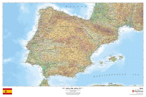
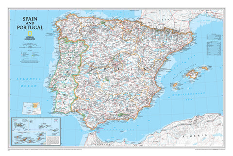
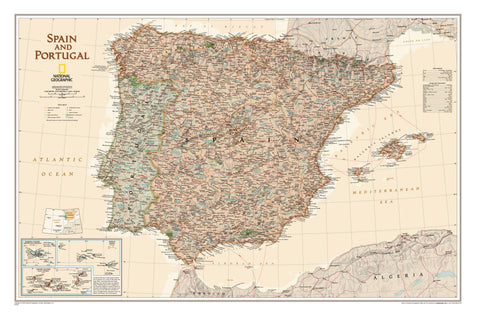
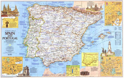
Camino de Santiago NGS Saint-Jean-Pied-De-Port to Santo Domingo de la Calzada Book No 1
$29.95
Afterpay is only available for orders between $50.00 and $1000.00 More info
🚶 Camino de Santiago – Saint-Jean-Pied-de-Port to Santo Domingo de la Calzada
National Geographic Topographic Map Guide – No. 1
Waterproof | Tear-Resistant | Detailed Trail Profiles
NEW PRODUCT – Please allow 10 days for delivery
Embark on one of the world’s most celebrated long-distance walking routes with this National Geographic Topographic Map Guide for the eastern section of the Camino Francés. Covering Saint-Jean-Pied-de-Port (France) to Santo Domingo de la Calzada (Spain), this guidebook maps Sections 1–9 of the Camino, providing detailed topographic mapping, trail profiles, and landmark descriptions to ensure your journey is as rewarding as it is unforgettable.
🗺️ About the Route
The Camino de Santiago—or El Camino, “The Way”—has inspired pilgrims and adventurers since the 9th century, when the remains of Saint James were said to have been discovered at Santiago de Compostela. While deeply rooted in Christian tradition, today the Camino is a nondenominational spiritual rite, attracting walkers from across the globe.
This section of the Camino Francés begins in the Basque foothills of Saint-Jean-Pied-de-Port, ascends across the Pyrenees, and descends into Spain’s Navarra region through Pamplona (Iruña), following ancient Roman roads, scenic countryside, and charming medieval towns.
📖 What’s Inside
-
Sections 1–9 of the Camino Francés – Fully mapped and described
-
Landmark Descriptions – Historical and cultural insights along the route
-
Inset Trail Profiles – Showing distances between towns, rest houses, and trail access points
-
Topographic Detail – 2 cm = 1 km scale for clear navigation
-
Page Overlap Mapping – Ensures no break in coverage for the walker
🌦️ Built for the Journey
Every National Geographic Great Treks map is printed on “Backcountry Tough” waterproof, tear-resistant paper—ready for unpredictable weather and heavy use. A full Latitude/Longitude grid is printed for GPS navigation, and the step-by-step layout keeps you on course without the need to backtrack.
📐 Map Specifications
| Feature | Detail |
|---|---|
| Scale | 1:50,000 |
| Trail Sections | 1–9 (Saint-Jean-Pied-de-Port to Santo Domingo de la Calzada) |
| Folded Size | 4.25" x 9.38" |
| Paper Type | Waterproof, tear-resistant |
| Publisher | National Geographic Society |
| Purpose | Hiking, pilgrimage, long-distance walking |
| Includes | Topographic maps, trail profiles, landmark descriptions |
💡 Why You’ll Love This Map Guide
✔️ Trusted National Geographic cartography for accuracy and clarity
✔️ Weatherproof design – perfect for real-world conditions
✔️ Compact and lightweight – easy to carry in a pocket or pack
✔️ Detailed profiles & overlaps – reduces the risk of getting lost
✔️ Supports global exploration – your purchase helps fund Nat Geo’s non-profit work in conservation, science, and education
🎁 Perfect For
-
Pilgrims walking the Camino Francés
-
Long-distance hikers and trekkers
-
History and culture enthusiasts
-
Gifts for walkers, travellers, and adventure seekers
🚚 Delivery
-
Please allow up to 10 working days for delivery
-
Carefully packed to arrive ready for your journey
With this map in hand, you’re not just walking a path—you’re following centuries of footsteps toward Santiago de Compostela.
👉 Order now and start your Camino with confidence.
Frequently Asked Questions
Where can I buy the Camino de Santiago NGS Saint-Jean-Pied-De-Port to Santo Domingo de la ?
The Camino de Santiago NGS Saint-Jean-Pied-De-Port to Santo Domingo de la is available to buy online from Mapworld, Australia's largest map and geographic product retailer, with fast shipping Australia-wide.
Is the Camino de Santiago NGS Saint-Jean-Pied-De-Port to Santo Domingo de la in stock at Mapworld?
Mapworld maintains extensive stock across its map range and aims for fast dispatch. Orders placed before 2pm AEST on business days are typically dispatched the same day, with standard and express Australia-wide delivery options available.
What is Mapworld's returns policy?
Mapworld accepts returns on undamaged items in original condition. Contact Mapworld within 90 days of purchase to arrange a return or exchange.
Does Mapworld ship the Camino de Santiago NGS Saint-Jean-Pied-De-Port to Santo Domingo de la across Australia?
Yes, Mapworld ships Australia-wide. Standard shipping is a flat $7 rate, with free standard shipping on orders over $75. Express options are available at checkout. Most orders placed before 2pm AEST on weekdays are dispatched same day.
Related Items
© 2026 Mapworld. Website designed by Genie Media
X