- Australia ▾
- Topographic
▾
- Australia AUSTopo 250k (2025)
- Australia 50k Geoscience maps
- Australia 100k Geoscience maps
- Australia 250k Geoscience maps
- Australia 1:1m Geoscience maps
- New Zealand 50k maps
- New Zealand 250k maps
- New South Wales 25k maps
- New South Wales 50k maps
- New South Wales 100k maps
- Queensland 10k maps
- Queensland 25k maps
- Queensland 50k maps
- Queensland 100k maps
- Western Australia 25k maps
- Western Australia 50k maps
- Western Australia 100k maps
- Compasses
- Software
- GPS Systems
- International ▾
- Wall Maps
▾
- World
- Australia & New Zealand
- Countries, Continents & Regions
- Historical
- Vintage National Geographic
- Australian Capital Territory
- New South Wales
- Northern Territory
- Queensland
- South Australia
- Tasmania
- Victoria
- Western Australia
- Celestial
- Children's
- Mining & Resources
- Wine Maps
- Healthcare
- Postcode Maps
- Electoral Maps
- Nautical ▾
- Flags
▾
- Australian Flag Sets & Banners
- Flag Bunting
- Handwavers
- Australian National Flags
- Aboriginal Flags
- Torres Strait Islander Flags
- International Flags
- Flagpoles & Accessories
- Australian Capital Territory Flags
- New South Wales Flags
- Northern Territory Flags
- Queensland Flags
- South Australia Flags
- Tasmania Flags
- Victoria Flags
- Western Australia Flags
- Gifts ▾
- Globes ▾
Dear valued customer. Please note that our checkout is not supported by old browsers. Please use a recent browser to access all checkout capabilities


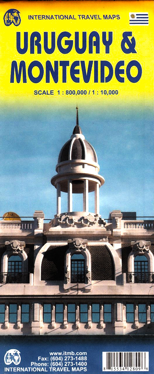
Uruguay / Montevideo ITMB Map
$24.95
Afterpay is only available for orders between $50.00 and $1000.00 More info
Double-Sided Travel Map | Montevideo City 1:10,000 + Uruguay Country 1:800,000
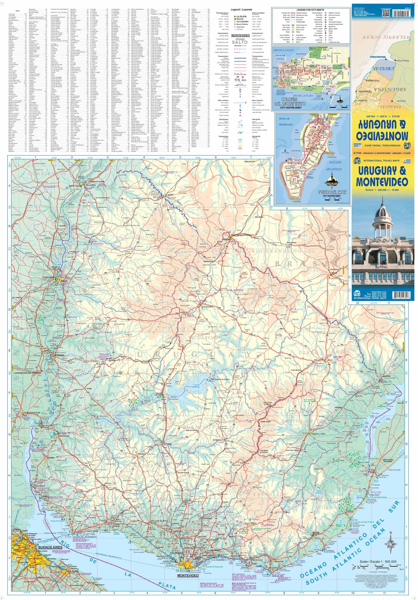
Size: 690 mm (W) x 990 mm (H)
Publisher: ITMB (International Travel Maps)
Discover Uruguay—From Capital Streets to Coastal Frontiers
This Uruguay & Montevideo ITMB map offers two essential maps in one expertly produced format. Whether you're navigating the charming, European-style streets of Montevideo or planning a road trip across Uruguay’s scenic countryside, this map is the ideal companion.
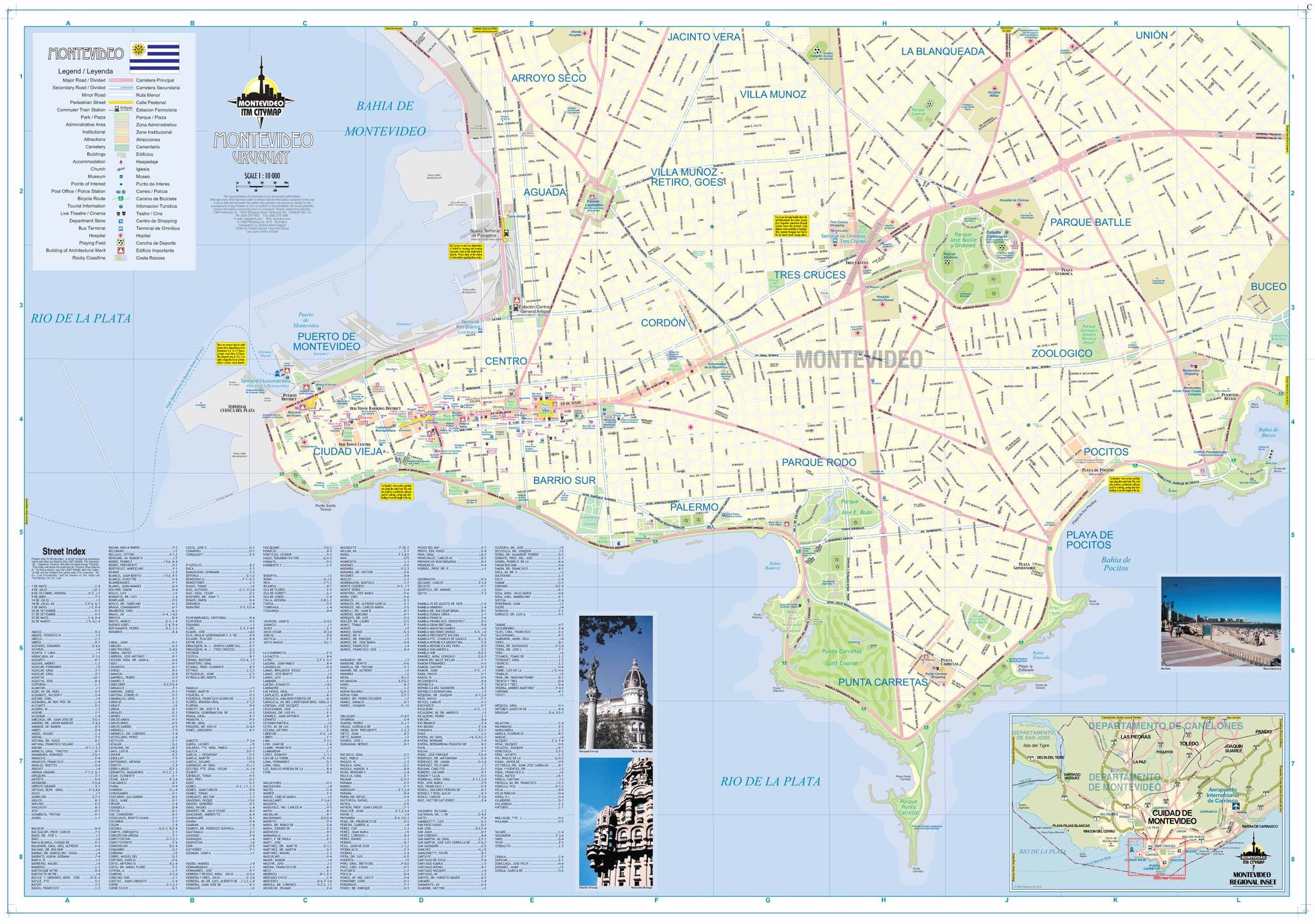
On one side, you'll find an up-to-date, easy-to-read street map of Montevideo, Uruguay’s vibrant capital. Key avenues, public transport routes, major hotels, embassies, landmarks, and neighbourhoods are clearly marked—perfect for both tourists and professionals.
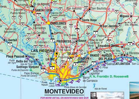
On the reverse, a country-scale road map of Uruguay reveals the nation’s extensive highway system, smaller roadways, protected natural areas, ferry routes, border crossings, and geographic features. From the beaches of Punta del Este to the historical architecture of Colonia del Sacramento, this map helps you navigate Uruguay's highlights with ease.
📌 Map Highlights
Montevideo Street Map (Scale 1:10,000)
-
Complete street index for navigation
-
Clearly marked suburbs and city districts
-
Public parks, cultural landmarks, and tourist attractions
-
Major hotels, consulates, and ferry terminals
-
Public transport connections
Uruguay Country Map (Scale 1:800,000)
-
All primary and secondary roads with route numbers
-
Distances in kilometres
-
Border crossings and ferry connections to Argentina
-
National parks and nature reserves
-
Rivers, lakes, and physical terrain features
-
Full index of towns and cities
🧭 A Practical Tool for Travel and Planning
This map is not just for tourists—it's equally suitable for:
-
Backpackers and road-trippers
-
Travel agents and tour guides
-
Educational settings and classrooms
-
Logistics teams and international businesses
-
Expats, embassy staff, and language learners
Its clarity, accuracy, and bilingual usability (with place names in local language) make it one of the most user-friendly resources available for navigating Uruguay.
💡 Lamination Option
For enhanced durability and reuse, we offer this map laminated using high-grade 80-micron gloss laminate. This encapsulation allows you to:
-
Use whiteboard markers to plot routes or notes
-
Add and remove map dots for logistics or teaching
-
Protect against moisture, UV fading, and tears
Please note: Laminated versions are produced by flattening and encapsulating the folded map, so minor fold lines will still be visible.
📐 Product Specifications
| Feature | Details |
|---|---|
| Map Type | Double-sided: City + Country |
| Montevideo Scale | 1:10,000 |
| Uruguay Scale | 1:800,000 |
| Map Dimensions | 690 mm (W) x 990 mm (H) |
| Finish Options | Folded paper / Laminated flat |
| Lamination Thickness | 80-micron gloss |
| Material | Paper or laminated map |
| Publisher | ITMB – International Travel Maps |
| Country of Origin | Canada |
🌍 Why Choose ITMB?
International Travel Maps (ITMB) is one of the world’s most trusted map publishers, known for their dedication to producing accurate, practical maps for the independent traveller. Their Uruguay & Montevideo map combines street-level precision with broad national perspective—perfectly balancing local detail with regional overview.
Frequently Asked Questions
Where can I buy the Uruguay / Montevideo ITMB Map?
The Uruguay / Montevideo ITMB Map is available to buy online from Mapworld, Australia's largest map and geographic product retailer, with fast shipping Australia-wide.
Is the Uruguay / Montevideo ITMB Map in stock at Mapworld?
Mapworld maintains extensive stock across its map range and aims for fast dispatch. Orders placed before 2pm AEST on business days are typically dispatched the same day, with standard and express Australia-wide delivery options available.
What is Mapworld's returns policy?
Mapworld accepts returns on undamaged items in original condition. Contact Mapworld within 90 days of purchase to arrange a return or exchange.
Does Mapworld ship the Uruguay / Montevideo ITMB Map across Australia?
Yes, Mapworld ships Australia-wide. Standard shipping is a flat $7 rate, with free standard shipping on orders over $75. Express options are available at checkout. Most orders placed before 2pm AEST on weekdays are dispatched same day.
Related Items


© 2026 Mapworld. Website designed by Genie Media
X