- Australia ▾
- Topographic
▾
- Australia AUSTopo 250k (2025)
- Australia 50k Geoscience maps
- Australia 100k Geoscience maps
- Australia 250k Geoscience maps
- Australia 1:1m Geoscience maps
- New Zealand 50k maps
- New Zealand 250k maps
- New South Wales 25k maps
- New South Wales 50k maps
- New South Wales 100k maps
- Queensland 10k maps
- Queensland 25k maps
- Queensland 50k maps
- Queensland 100k maps
- Western Australia 25k maps
- Western Australia 50k maps
- Western Australia 100k maps
- Compasses
- Software
- GPS Systems
- International ▾
- Wall Maps
▾
- World
- Australia & New Zealand
- Countries, Continents & Regions
- Historical
- Vintage National Geographic
- Australian Capital Territory
- New South Wales
- Northern Territory
- Queensland
- South Australia
- Tasmania
- Victoria
- Western Australia
- Celestial
- Children's
- Mining & Resources
- Wine Maps
- Healthcare
- Postcode Maps
- Electoral Maps
- Nautical ▾
- Flags
▾
- Australian Flag Sets & Banners
- Flag Bunting
- Handwavers
- Australian National Flags
- Aboriginal Flags
- Torres Strait Islander Flags
- International Flags
- Flagpoles & Accessories
- Australian Capital Territory Flags
- New South Wales Flags
- Northern Territory Flags
- Queensland Flags
- South Australia Flags
- Tasmania Flags
- Victoria Flags
- Western Australia Flags
- Gifts ▾
- Globes ▾
Dear valued customer. Please note that our checkout is not supported by old browsers. Please use a recent browser to access all checkout capabilities


Nicaragua & Honduras ITMB Travel Reference Map
$24.95
Afterpay is only available for orders between $50.00 and $1000.00 More info
By ITMB Publishing | Folded Map – Optional Lamination
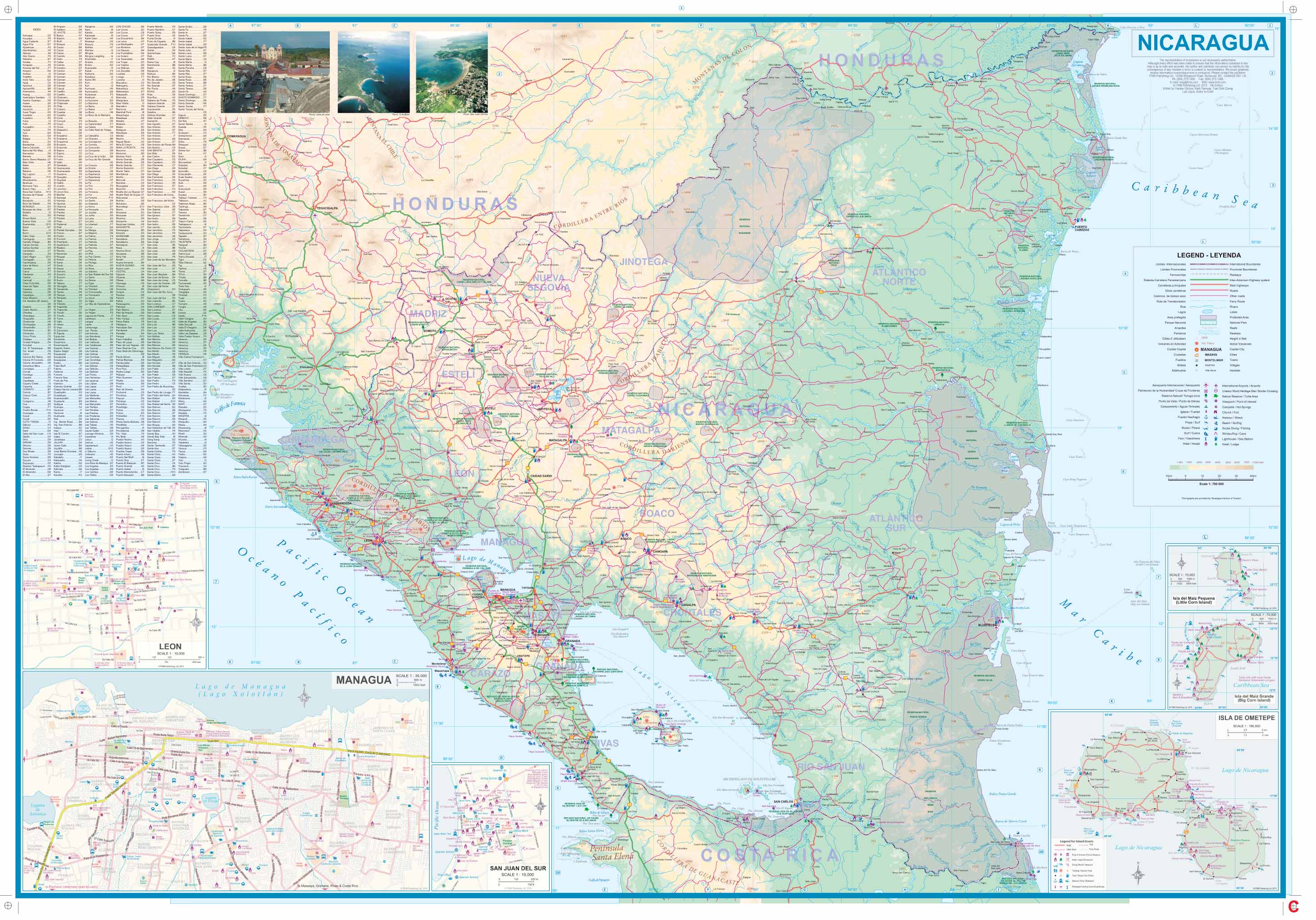
Scale: 1:700,000 (Nicaragua) / 1:250,000 (Honduras)
Size: 690 mm x 1000 mm
ISBN: 9781771293303
Edition: Latest Edition
🌎 Explore Two Central American Gems on One Expertly Crafted Map
Embark on an unforgettable journey through two of Central America's most captivating destinations with this double-sided map by International Travel Maps (ITMB). Covering both Nicaragua and Honduras, this map is designed for adventurous travellers, cultural explorers, and anyone interested in the unique geography and history of the region.
Whether you're planning to visit colonial towns, explore lush jungles, discover indigenous heritage sites, or simply chart your course along scenic coastal routes, this map will be your trustworthy travel companion.
🧭 Map Features at a Glance:
🇭🇳 Side 1: Honduras (Scale 1:250,000)
-
✅ Clear road network with highways, secondary roads & access routes
-
🏛️ Includes Copán Ruins, a major Mayan archaeological site
-
🏞️ Highlights Lake Yojoa, Gracias, and Valley of the Angels
-
🏙️ Large inset map of Tegucigalpa, the nation's capital
-
🌄 Mountain ranges, rivers, and parks accurately shaded
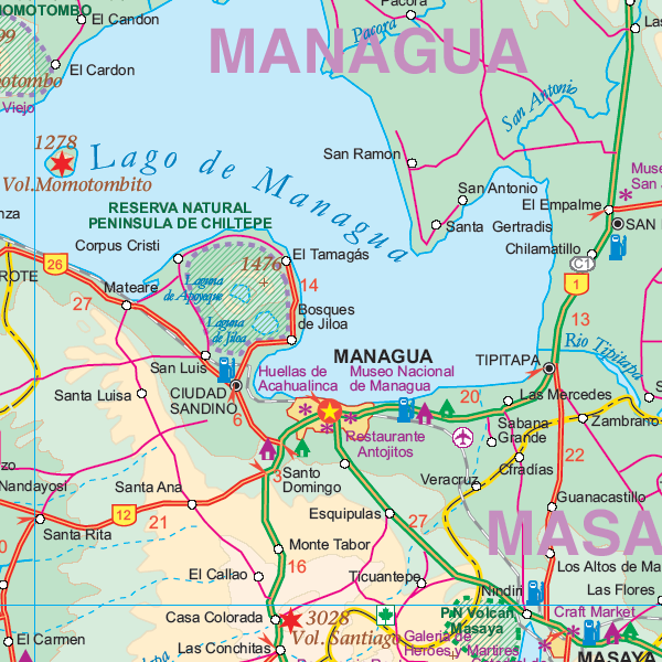
🇳🇮 Side 2: Nicaragua (Scale 1:700,000)
-
🏘️ Features Granada, founded in 1534 — one of the oldest cities in the Americas
-
🌊 Displays Lake Nicaragua, Ometepe Island, and fishing villages along the coast
-
🏔️ Covers the Matagalpa Highlands and volcanic landscapes
-
🗺️ Includes a detailed inset map of Managua, the capital
-
🎨 Marks cultural hotspots like San Juan de Oriente (pottery & crafts)
📌 Additional Highlights:
| ✅ Feature | ✔️ Included |
|---|---|
| Double-Sided Map | Nicaragua & Honduras on separate sides |
| Fully Indexed | Easy-to-use place name index |
| Tourist Sites | Archaeological ruins, towns, & landmarks |
| Topography | Elevation shading, rivers, lakes, volcanoes |
| Urban Insets | Managua & Tegucigalpa |
| Language | English |
| Ideal Use | Travel, teaching, trip planning |
💧 Upgrade to Laminated Map (Optional)
Add a protective 80-micron gloss lamination for a durable, reusable finish:
-
🖊️ Write on it with whiteboard markers
-
📍 Add and remove map dots or stickers
-
💪 Water-resistant, tear-resistant, and long-lasting
-
📦 Laminated maps are flattened prior to sealing — fold lines may remain subtly visible
📐 Map Specifications
| Attribute | Details |
|---|---|
| Format | Folded map (laminated optional) |
| Dimensions | 690 mm x 1000 mm |
| Scale | 1:700,000 / 1:250,000 |
| Paper Stock | Durable travel-grade paper |
| Lamination Option | 80-micron gloss encapsulation |
| Mounting Option | Timber hang rails (laminated only) |
| Publisher | ITMB (International Travel Maps) |
| ISBN | 9781771293303 |
👥 Who Is This Map For?
-
🌍 Travellers exploring Central America
-
🧭 Backpackers and overlanders journeying through lesser-known routes
-
🏫 Teachers & educators seeking regional context
-
🏞️ Nature lovers & archaeologists interested in topography and heritage
-
🎒 Cultural tourists visiting colonial towns and traditional villages
📦 Delivery Notes
-
✅ In-stock folded maps dispatch within 2 working days
-
🧰 Laminated Allow 7–10 working days
-
🌐 Ships worldwide – delivery times vary by destination
📚 Pair this map with a Central America guidebook or our laminated wall map for the full planning experience.
Frequently Asked Questions
Where can I buy the Nicaragua & Honduras ITMB Travel Reference Map?
The Nicaragua & Honduras ITMB Travel Reference Map is available to buy online from Mapworld, Australia's largest map and geographic product retailer, with fast shipping Australia-wide.
Is the Nicaragua & Honduras ITMB Travel Reference Map in stock at Mapworld?
Mapworld maintains extensive stock across its map range and aims for fast dispatch. Orders placed before 2pm AEST on business days are typically dispatched the same day, with standard and express Australia-wide delivery options available.
What is Mapworld's returns policy?
Mapworld accepts returns on undamaged items in original condition. Contact Mapworld within 90 days of purchase to arrange a return or exchange.
Does Mapworld ship the Nicaragua & Honduras ITMB Travel Reference Map across Australia?
Yes, Mapworld ships Australia-wide. Standard shipping is a flat $7 rate, with free standard shipping on orders over $75. Express options are available at checkout. Most orders placed before 2pm AEST on weekdays are dispatched same day.
Related Items


© 2026 Mapworld. Website designed by Genie Media
X