- Australia ▾
- Topographic
▾
- Australia AUSTopo 250k (2025)
- Australia 50k Geoscience maps
- Australia 100k Geoscience maps
- Australia 250k Geoscience maps
- Australia 1:1m Geoscience maps
- New Zealand 50k maps
- New Zealand 250k maps
- New South Wales 25k maps
- New South Wales 50k maps
- New South Wales 100k maps
- Queensland 10k maps
- Queensland 25k maps
- Queensland 50k maps
- Queensland 100k maps
- Western Australia 25k maps
- Western Australia 50k maps
- Western Australia 100k maps
- Compasses
- Software
- GPS Systems
- International ▾
- Wall Maps
▾
- World
- Australia & New Zealand
- Countries, Continents & Regions
- Historical
- Vintage National Geographic
- Australian Capital Territory
- New South Wales
- Northern Territory
- Queensland
- South Australia
- Tasmania
- Victoria
- Western Australia
- Celestial
- Children's
- Mining & Resources
- Wine Maps
- Healthcare
- Postcode Maps
- Electoral Maps
- Nautical ▾
- Flags
▾
- Australian Flag Sets & Banners
- Flag Bunting
- Handwavers
- Australian National Flags
- Aboriginal Flags
- Torres Strait Islander Flags
- International Flags
- Flagpoles & Accessories
- Australian Capital Territory Flags
- New South Wales Flags
- Northern Territory Flags
- Queensland Flags
- South Australia Flags
- Tasmania Flags
- Victoria Flags
- Western Australia Flags
- Gifts ▾
- Globes ▾
Dear valued customer. Please note that our checkout is not supported by old browsers. Please use a recent browser to access all checkout capabilities


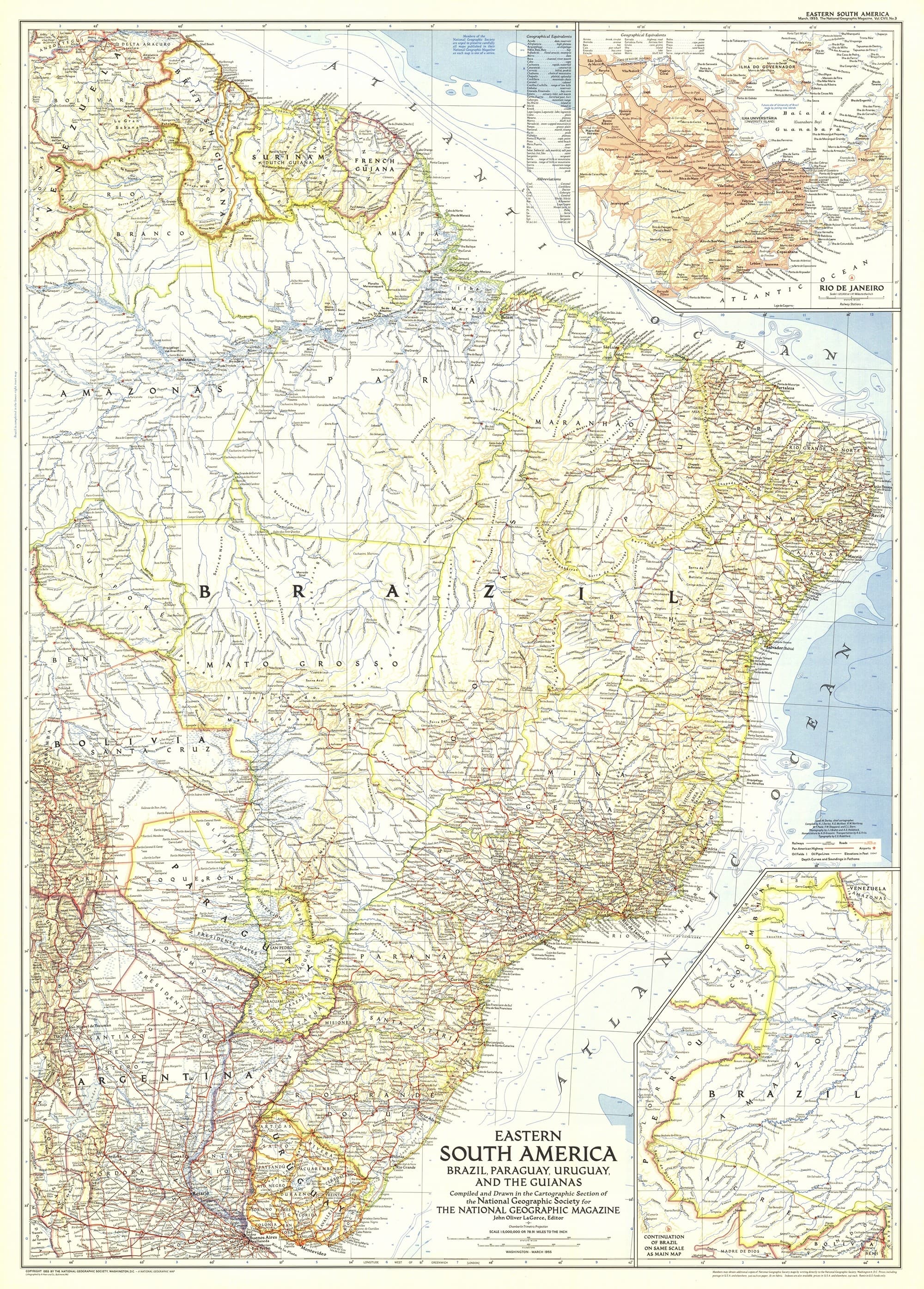
Eastern South America Wall Map - Published 1955 by National Geographic
$69.95
or make 4 interest-free payments of
$17.49 AUD
fortnightly with
![]() More info
More info
Size: 735 × 1026 mm | Published: 1955 | Made in Australia
🌍 A Mid-Century View of a Continent in Transition
Travel back to the golden era of cartography with this exquisitely detailed 1955 Eastern South America wall map from National Geographic. This is not just a map—it’s a meticulously crafted snapshot of an era when much of the continent was still defined by vast rainforests, roadless wilderness, and mighty rivers that had yet to be fully charted.
Published in March 1955, this map was part of a feature issue that explored both the vibrancy of Brazil’s cities and the deep traditions of its indigenous peoples. It accompanied two remarkable articles:
-
“Spectacular Rio de Janeiro” – capturing the city’s glittering coastline, Sugarloaf Mountain, and the vibrant rhythm of its streets long before the boom of modern high-rises.
-
“Life Among the Wai Wai Indians” – an intimate portrayal of an indigenous community whose way of life was far removed from the outside world.
The map also features a dedicated inset of Rio de Janeiro, allowing viewers to study the intricate geography of the city in rich mid-century detail.
This map pairs beautifully with National Geographic’s 1958 Southern South America map, offering collectors and enthusiasts a complete view of the continent’s southern half as it appeared in the post-war years.
📐 Cartographic Features
-
Publication Year: 1955
-
Inset: Detailed map of Rio de Janeiro and its surroundings.
-
Coverage: Brazil, Uruguay, Paraguay, Suriname, French Guiana, parts of Argentina, Venezuela, and the Amazon Basin.
-
Topography: Illustrated with shaded relief to bring mountain ranges and river systems to life.
-
Design: Rich, saturated colours characteristic of National Geographic’s mid-century style, with fine-lined typography for exceptional readability.
-
Size: 735 mm (wide) × 1026 mm (high)
🖌 Premium Print & Display Options
| Format | Description |
|---|---|
| Paper (160 gsm) | Heavyweight matte-coated paper – ideal for framing under glass. |
| Laminated | Fully encapsulated in two sheets of 80-micron gloss laminate for durability, water resistance, and easy cleaning. |
| Laminated + Hang Rails | Laminated map with smooth natural timber rails and a hanging cord – display-ready on arrival. |
| Canvas (395 gsm) | HP Professional Matte Canvas with archival pigment inks for texture, durability, and fade resistance. |
| Canvas + Hang Rails | Canvas map with natural timber rails for an elegant, heritage-style display. |
Note: Please allow up to 10 working days for delivery of hang-railed maps, as each one is professionally mounted by our framer.
🎯 Perfect For
-
Collectors – An authentic reproduction of a mid-century National Geographic masterpiece.
-
Brazil Enthusiasts – Captures the nation before its modern transformation, with an intimate look at Rio de Janeiro.
-
Historians & Educators – An invaluable visual resource for teaching the cultural, political, and physical geography of South America.
-
Interior Styling – Adds vintage travel charm to studies, libraries, offices, or living spaces.
🌟 Why This Map Stands Out
-
Historic Provenance – Direct from the pages of National Geographic’s March 1955 edition.
-
Incredible Detail – From major cities to remote rivers, it presents Eastern South America as it was over six decades ago.
-
Archival-Quality Printing – Crisp lines, vibrant colour, and exceptional clarity in every format.
-
Australian Made – Printed to order using professional-grade materials.
Bring the colour, history, and romance of 1950s South America into your home, office, or classroom. This Eastern South America wall map offers more than just a view of the land—it’s a window into a world on the cusp of change.
📍 Order today and own a piece of cartographic history that will inspire conversation and admiration for years to come.
Frequently Asked Questions
What are the dimensions of the Eastern South America Wall Map - Published 1955 by National Geographic?
Mapworld wall maps range from standard 700×1000mm to large-format 1000×1430mm Supermaps. The exact dimensions for this map are shown in the product title. Where multiple sizes are available, select your preferred size when adding to cart.
Is this wall map available laminated?
Many Mapworld wall maps are available in paper, laminated, or framed finishes. Check the product options when adding to cart. Laminated maps are wipe-clean and more durable.
Is this the latest edition?
Mapworld stocks the most current editions available from all publishers. Edition year is shown in the product title where applicable. Mapworld updates its catalogue as new editions are released.
Can I write on or pin this wall map?
Laminated wall maps can be written on with whiteboard markers and wiped clean. Paper maps can be pinned on a corkboard. Choose a laminated option for a writeable surface.
Does Mapworld ship the Eastern South America Wall Map - Published 1955 by National Geographic across Australia?
Yes, Mapworld ships Australia-wide. Standard shipping is a flat $7 rate, with free standard shipping on orders over $75. Express options are available at checkout. Most orders placed before 2pm AEST on weekdays are dispatched same day.
Related Items


© 2026 Mapworld. Website designed by Genie Media
X