- Australia ▾
- Topographic
▾
- Australia AUSTopo 250k (2025)
- Australia 50k Geoscience maps
- Australia 100k Geoscience maps
- Australia 250k Geoscience maps
- Australia 1:1m Geoscience maps
- New Zealand 50k maps
- New Zealand 250k maps
- New South Wales 25k maps
- New South Wales 50k maps
- New South Wales 100k maps
- Queensland 10k maps
- Queensland 25k maps
- Queensland 50k maps
- Queensland 100k maps
- Western Australia 25k maps
- Western Australia 50k maps
- Western Australia 100k maps
- Compasses
- Software
- GPS Systems
- International ▾
- Wall Maps
▾
- World
- Australia & New Zealand
- Countries, Continents & Regions
- Historical
- Vintage National Geographic
- Australian Capital Territory
- New South Wales
- Northern Territory
- Queensland
- South Australia
- Tasmania
- Victoria
- Western Australia
- Celestial
- Children's
- Mining & Resources
- Wine Maps
- Healthcare
- Postcode Maps
- Electoral Maps
- Nautical ▾
- Flags
▾
- Australian Flag Sets & Banners
- Flag Bunting
- Handwavers
- Australian National Flags
- Aboriginal Flags
- Torres Strait Islander Flags
- International Flags
- Flagpoles & Accessories
- Australian Capital Territory Flags
- New South Wales Flags
- Northern Territory Flags
- Queensland Flags
- South Australia Flags
- Tasmania Flags
- Victoria Flags
- Western Australia Flags
- Gifts ▾
- Globes ▾
Dear valued customer. Please note that our checkout is not supported by old browsers. Please use a recent browser to access all checkout capabilities


Cuzco & Peru South ITMB Map
$24.95
Afterpay is only available for orders between $50.00 and $1000.00 More info
Scale: 1:110,000 / 1:1,500,000
Edition: 4th Edition (2011)
Flat Size: 690 mm x 1000 mm (27" x 39")
Publisher: ITMB (International Travel Maps)
Explore the legendary heartland of the Inca Empire with this beautifully detailed travel map of Cuzco and Southern Peru by ITMB. Ideal for travellers trekking to Machu Picchu, hiking the Inca Trail, or exploring Peru’s southern highlands by road, this map combines accurate topographic detail with practical city and site insets.
Whether you're navigating the bustling streets of Cuzco, planning a sacred valley itinerary, or tracing Peru’s dramatic Andean routes, this map is a must-have companion.
📌 Map Coverage & Insets
This double-sided map provides extensive coverage and exceptional value, combining regional and detailed local maps:
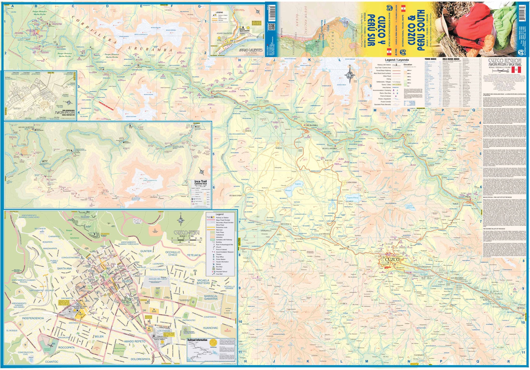
🧭 Side 1: Cuzco & City Insets
-
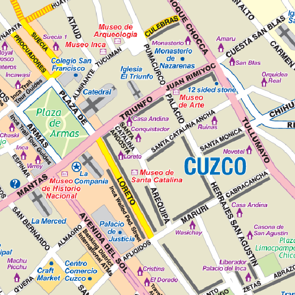
🏙️ Cuzco City Map – 1:11,000
-
🗺️ Machu Picchu Site Plan – Schematic layout
-
🥾 Inca Trail Route – 1:50,000
-
🌆 Lima City Centre – 1:13,500
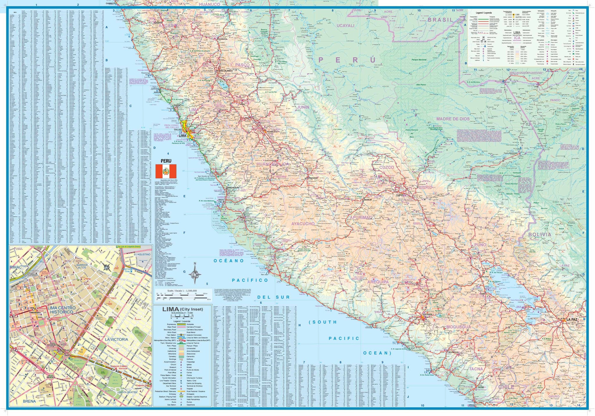
🏞️ Side 2: Southern Peru
-
Covers the entire southern half of Peru at 1:1,500,000, from Lima to Lake Titicaca, including:
-
Arequipa
-
Nazca
-
Puno
-
Puerto Maldonado
-
Sacred Valley
-
🌄 Key Features
-
🧭 Topographic Shading: Shaded relief gives a clear sense of Peru’s dramatic elevation changes — essential for planning treks and routes.
-
🛣️ Road Network & Highways: All major routes, secondary roads, and unpaved tracks clearly marked, including distances.
-
🚉 Transport Hubs: Railway lines, airports, and river ports included.
-
🏛️ Tourist Sites & Points of Interest: Major archaeological sites, towns, parks, and reserves are all pinpointed.
-
🗺️ City street plans: Navigate Cuzco, Lima, and access key tourist zones with confidence.
🧾 Map Specifications
| Feature | Details |
|---|---|
| Publisher | ITMB (International Travel Maps) |
| Edition | 4th Edition |
| Year | 2011 |
| Main Scales | 1:110,000 (Cuzco) / 1:1,500,000 (Region) |
| Insets | Cuzco, Lima, Inca Trail, Machu Picchu |
| Size (Flat) | 690 mm x 1000 mm (27" x 39") |
| Format | Folded paper map |
| ISBN | [ISBN not provided] |
🛡️ Optional Lamination Available
For increased durability we offer this map in a laminated format:
-
💧 Waterproof & tear-resistant
-
🧽 Wipeable surface – use with whiteboard markers or map dots for planning
-
🧱 Encapsulated in 80-micron laminate – strong and long-lasting
Perfect for classroom walls, or travel agency displays.
✨ Who Is This Map For?
This map is ideal for:
-
🥾 Trekker & hikers walking the Inca Trail or Sacred Valley
-
📷 Travellers & backpackers visiting Cuzco, Machu Picchu, and Southern Peru
-
🧳 Tour planners & guides organising Peruvian itineraries
-
🗺️ Map collectors & cultural explorers interested in Inca history and geography
-
🏫 Educators & students studying Andean geography and history
🇵🇪 Why Choose This Map?
Cuzco is more than just a gateway to Machu Picchu — it’s a living museum of Inca and Spanish heritage, surrounded by some of the most iconic landscapes in South America. This map puts the full region into perspective, helping you connect ancient routes, modern cities, and natural wonders.
Start your journey through the Sacred Valley with this expertly designed and travel-tested map. Whether by bus, train, foot, or imagination—Southern Peru is waiting to be discovered.
Frequently Asked Questions
Where can I buy the Cuzco & Peru South ITMB Map?
The Cuzco & Peru South ITMB Map is available to buy online from Mapworld, Australia's largest map and geographic product retailer, with fast shipping Australia-wide.
Is the Cuzco & Peru South ITMB Map in stock at Mapworld?
Mapworld maintains extensive stock across its map range and aims for fast dispatch. Orders placed before 2pm AEST on business days are typically dispatched the same day, with standard and express Australia-wide delivery options available.
What is Mapworld's returns policy?
Mapworld accepts returns on undamaged items in original condition. Contact Mapworld within 90 days of purchase to arrange a return or exchange.
Does Mapworld ship the Cuzco & Peru South ITMB Map across Australia?
Yes, Mapworld ships Australia-wide. Standard shipping is a flat $7 rate, with free standard shipping on orders over $75. Express options are available at checkout. Most orders placed before 2pm AEST on weekdays are dispatched same day.
Related Items


© 2026 Mapworld. Website designed by Genie Media
X