- Australia ▾
- Topographic
▾
- Australia AUSTopo 250k (2025)
- Australia 50k Geoscience maps
- Australia 100k Geoscience maps
- Australia 250k Geoscience maps
- Australia 1:1m Geoscience maps
- New Zealand 50k maps
- New Zealand 250k maps
- New South Wales 25k maps
- New South Wales 50k maps
- New South Wales 100k maps
- Queensland 10k maps
- Queensland 25k maps
- Queensland 50k maps
- Queensland 100k maps
- Western Australia 25k maps
- Western Australia 50k maps
- Western Australia 100k maps
- Compasses
- Software
- GPS Systems
- International ▾
- Wall Maps
▾
- World
- Australia & New Zealand
- Countries, Continents & Regions
- Historical
- Vintage National Geographic
- Australian Capital Territory
- New South Wales
- Northern Territory
- Queensland
- South Australia
- Tasmania
- Victoria
- Western Australia
- Celestial
- Children's
- Mining & Resources
- Wine Maps
- Healthcare
- Postcode Maps
- Electoral Maps
- Nautical ▾
- Flags
▾
- Australian Flag Sets & Banners
- Flag Bunting
- Handwavers
- Australian National Flags
- Aboriginal Flags
- Torres Strait Islander Flags
- International Flags
- Flagpoles & Accessories
- Australian Capital Territory Flags
- New South Wales Flags
- Northern Territory Flags
- Queensland Flags
- South Australia Flags
- Tasmania Flags
- Victoria Flags
- Western Australia Flags
- Gifts ▾
- Globes ▾
Dear valued customer. Please note that our checkout is not supported by old browsers. Please use a recent browser to access all checkout capabilities


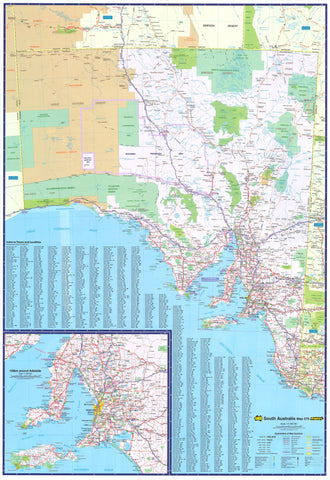
Perth-Adelaide-Alice Springs Laminated Wall Map QPA
$49.95
Afterpay is only available for orders between $50.00 and $1000.00 More info
Double-Sided | Eyre Highway & Inland Route | Outback-Ready
Scale: Approx. 1:2,000,000 Size: 1020 mm (W) x 700 mm (H)
Format: Gloss Laminated for durability and reusability
🚗 The Ultimate Journey Across Australia's Vast Interior
Whether you’re planning an iconic road trip across the Eyre Highway, an inland trek to Alice Springs, or a multi-day adventure linking Western Australia, South Australia, and the Northern Territory, this double-sided wall map by QPA is your perfect companion.
It not only traces the popular tourist routes from Perth to Adelaide and north to Alice Springs, but also offers essential detail of the vast and beautiful countryside in between — including outback towns, fuel stops, and natural features.
This map is ideal for travellers, caravanners, route planners, and businesses involved in logistics across central and western Australia.
🧭 Map Features
-
🛣️ Detailed Road Mapping
Shows major highways, including the full length of the Eyre Highway and its branching inland routes -
🧭 Double-Sided Coverage
-
Side A: Perth to Nullarbor Roadhouse
-
Side B: Nullarbor Roadhouse to Adelaide and up to Alice Springs
-
-
🗺️ Inset Maps
Regional blow-up maps of Perth, Adelaide, and Alice Springs provide added local detail -
🏕️ Camping Areas & Fuel Stops
Essential services clearly marked for trip planning -
🧳 Tourist Icons & Attractions
Includes points of interest along the route -
📏 Comprehensive Legend
Easy-to-read key covering road classifications, rest areas, and facilities
🧼 Durable Laminated Finish
This map is laminated with high-quality gloss film, making it:
-
🧽 Wipe-clean – Use whiteboard markers to plot your journey or update logistics
-
🛡️ Tear-resistant – Perfect for repeated handling or transport use
-
📌 Pin- or magnet-friendly – Ideal for display in homes, offices, or travel centres
📐 Product Specifications
| Feature | Detail |
|---|---|
| Dimensions | 1020 mm (W) x 700 mm (H) |
| Scale | Approx. 1:2,000,000 |
| Format | Double-sided / Laminated |
| Map Coverage | Perth, Nullarbor, Adelaide, Alice Springs |
| Inset Maps | Perth • Adelaide • Alice Springs |
| Publisher | QPA Maps |
Who This Map Is For
✔️ Grey nomads & overland travellers planning cross-country drives
✔️ 4WD enthusiasts navigating through Australia’s remote interior
✔️ Transport companies & route planners mapping logistics across multiple states
✔️ Travel agencies offering guided outback tours
✔️ Teachers & geography lovers seeking accurate, large-format references
Get Your Bearings Across Australia’s Wildest Terrain
The Perth–Adelaide–Alice Springs Laminated Wall Map brings the spirit of the outback to your wall — combining practicality with inspiration. Whether you’re drawing up travel plans or just daydreaming about the next adventure, this map is the perfect guide.
Frequently Asked Questions
What are the dimensions of the Perth-Adelaide-Alice Springs Laminated Wall Map QPA?
Mapworld wall maps range from standard 700×1000mm to large-format 1000×1430mm Supermaps. The exact dimensions for this map are shown in the product title. Where multiple sizes are available, select your preferred size when adding to cart.
Is this wall map available laminated?
Many Mapworld wall maps are available in paper, laminated, or framed finishes. Check the product options when adding to cart. Laminated maps are wipe-clean and more durable.
Is this the latest edition?
Mapworld stocks the most current editions available from all publishers. Edition year is shown in the product title where applicable. Mapworld updates its catalogue as new editions are released.
Can I write on or pin this wall map?
Laminated wall maps can be written on with whiteboard markers and wiped clean. Paper maps can be pinned on a corkboard. Choose a laminated option for a writeable surface.
Does Mapworld ship the Perth-Adelaide-Alice Springs Laminated Wall Map QPA across Australia?
Yes, Mapworld ships Australia-wide. Standard shipping is a flat $7 rate, with free standard shipping on orders over $75. Express options are available at checkout. Most orders placed before 2pm AEST on weekdays are dispatched same day.
Related Items


© 2026 Mapworld. Website designed by Genie Media
X