- Australia ▾
- Topographic
▾
- Australia AUSTopo 250k (2025)
- Australia 50k Geoscience maps
- Australia 100k Geoscience maps
- Australia 250k Geoscience maps
- Australia 1:1m Geoscience maps
- New Zealand 50k maps
- New Zealand 250k maps
- New South Wales 25k maps
- New South Wales 50k maps
- New South Wales 100k maps
- Queensland 10k maps
- Queensland 25k maps
- Queensland 50k maps
- Queensland 100k maps
- Western Australia 25k maps
- Western Australia 50k maps
- Western Australia 100k maps
- Compasses
- Software
- GPS Systems
- International ▾
- Wall Maps
▾
- World
- Australia & New Zealand
- Countries, Continents & Regions
- Historical
- Vintage National Geographic
- Australian Capital Territory
- New South Wales
- Northern Territory
- Queensland
- South Australia
- Tasmania
- Victoria
- Western Australia
- Celestial
- Children's
- Mining & Resources
- Wine Maps
- Healthcare
- Postcode Maps
- Electoral Maps
- Nautical ▾
- Flags
▾
- Australian Flag Sets & Banners
- Flag Bunting
- Handwavers
- Australian National Flags
- Aboriginal Flags
- Torres Strait Islander Flags
- International Flags
- Flagpoles & Accessories
- Australian Capital Territory Flags
- New South Wales Flags
- Northern Territory Flags
- Queensland Flags
- South Australia Flags
- Tasmania Flags
- Victoria Flags
- Western Australia Flags
- Gifts ▾
- Globes ▾
Dear valued customer. Please note that our checkout is not supported by old browsers. Please use a recent browser to access all checkout capabilities


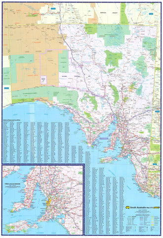
Adelaide & Region Hema 700 x 1000mm Laminated Wall Map with Hang Rails
$225.00
or make 4 interest-free payments of
$56.25 AUD
fortnightly with
![]() More info
More info
Laminated & Hang-Railed Edition
Greater Adelaide Map with Postcodes, Roads & Freeway Planning
Scale: 1:80,000 | Size: 700 × 1000 mm
🖼️ Printed in Australia on archival materials, professionally mounted for display
Bring function and flair to your wall with this high-quality laminated wall map of Greater Adelaide, created by Hema Maps and beautifully finished with natural timber hang rails. Designed for clarity, durability, and professional use, this map offers a highly detailed view of Adelaide’s metropolitan area — ideal for sales planning, delivery mapping, education, or simply showcasing your love for South Australia’s capital.
🧭 Detailed Coverage
This map includes the entire Greater Adelaide region, stretching:
-
North to Gawler Belt
-
South to Willunga
-
East to Charleston
-
West to the coast of Gulf St Vincent
It covers all key suburbs, arterial roads, and infrastructure corridors, making it an indispensable tool for urban planning, logistics, and geographical reference.
🔍 Features at a Glance
| ✔️ Feature | 💬 Description |
|---|---|
| 🛣️ Road Network Detail | Shows all primary and secondary roads, including collector routes and local streets |
| 🚦 Route Markings | Full national, state, and metropolitan route numbers displayed |
| 🛤️ Freeways & Bypasses | Highlights current and future freeway infrastructure |
| 🏘️ Suburb Labelling | All local suburbs clearly marked and identified |
| 📮 Postcode Boundaries | Accurate postcode divisions for logistics, sales, or service planning |
| 📌 Planning Grade Clarity | Clear and legible layout suitable for wall viewing and project discussion |
| 🖊️ Reusable Surface | Write-on/wipe-off surface — great for dry-erase markers and Mark-It-Dots |
🖼️ Presentation & Materials
This edition is not just functional — it’s ready to hang as a professional wall display:
-
Map Material:
Printed on FSC-certified 120gsm matte-coated paper using archival pigment inks for rich colour fidelity and fade resistance -
Lamination:
True encapsulation in 80-micron gloss laminate (both sides) for long-lasting protection, water resistance, and whiteboard compatibility -
Mounting:
Supplied fully assembled with natural timber wooden hang rails (top and bottom), finished with a lacquer coating and a hanging cord attached to the top rail
➤ Simply hook on the wall and you're done
📐 Product Specifications
| Property | Detail |
|---|---|
| Map Title | Adelaide & Region Wall Map |
| Publisher | Hema Maps |
| Scale | 1:80,000 |
| Dimensions | 700 mm (W) × 1000 mm (H) |
| Finish | Laminated (80-micron gloss both sides) |
| Mounting | Timber hang rails (top & bottom) with hanging cord |
| Paper | 120gsm FSC matte-coated |
| Ink Type | Archival pigment-based |
| Printed In | Australia |
| Delivery Time | Please allow 10 working days (custom hand-framed to order) |
🧳 Ideal For:
-
🏢 Business Owners & Sales Teams
Define service areas, optimise delivery routes, and visualise regional sales zones -
🚛 Logistics & Transport Operators
Pinpoint depots, plan journeys, and assign coverage areas across Adelaide’s suburbs -
🏫 Educators & Schools
Display as a teaching tool for geography, civics, or planning exercises -
🧱 Builders & Developers
Understand zoning boundaries, future infrastructure, and growth corridors -
🧾 Government & Community Planners
Suitable for boardrooms, offices, and public engagement venues -
🏠 Home Offices or Map Enthusiasts
Celebrate your connection to Adelaide with a bold, beautifully presented map
🛠️ Also Available (By Request)
Looking for different finishes? We also offer:
-
📄 Paper-only version – ideal for traditional glass framing
-
🧽 Flat laminated version (no rails) – perfect for whiteboards or pinning
-
🖼️ Canvas print with wooden hang rails – high-end decorative finish for homes, wineries, or offices
🛒 Add to Cart – Premium Adelaide Wall Map, Ready to Hang
Whether you’re managing a growing team, running a regional office, or just love local cartography, this map is both a powerful tool and a beautiful display piece.
✔️ Laminated for daily use
✔️ Hang rails included — no extra framing needed
✔️ Made and printed in Australia
✔️ Custom-packed with care
📦 Note: Hang-railed maps are custom-mounted. Please allow 10 working days for delivery.
Frequently Asked Questions
What are the dimensions of the Adelaide & Region Hema 700 x 1000mm Laminated Wall Map with Hang Rails?
Mapworld wall maps range from standard 700×1000mm to large-format 1000×1430mm Supermaps. The exact dimensions for this map are shown in the product title. Where multiple sizes are available, select your preferred size when adding to cart.
Is this wall map available laminated?
Many Mapworld wall maps are available in paper, laminated, or framed finishes. Check the product options when adding to cart. Laminated maps are wipe-clean and more durable.
Is this the latest edition?
Mapworld stocks the most current editions available from all publishers. Edition year is shown in the product title where applicable. Mapworld updates its catalogue as new editions are released.
Can I write on or pin this wall map?
Laminated wall maps can be written on with whiteboard markers and wiped clean. Paper maps can be pinned on a corkboard. Choose a laminated option for a writeable surface.
Does Mapworld ship the Adelaide & Region Hema 700 x 1000mm Laminated Wall Map with Hang Rails across Australia?
Yes, Mapworld ships Australia-wide. Standard shipping is a flat $7 rate, with free standard shipping on orders over $75. Express options are available at checkout. Most orders placed before 2pm AEST on weekdays are dispatched same day.
Related Items


© 2026 Mapworld. Website designed by Genie Media
X