- Australia ▾
- Topographic
▾
- Australia AUSTopo 250k (2025)
- Australia 50k Geoscience maps
- Australia 100k Geoscience maps
- Australia 250k Geoscience maps
- Australia 1:1m Geoscience maps
- New Zealand 50k maps
- New Zealand 250k maps
- New South Wales 25k maps
- New South Wales 50k maps
- New South Wales 100k maps
- Queensland 10k maps
- Queensland 25k maps
- Queensland 50k maps
- Queensland 100k maps
- Western Australia 25k maps
- Western Australia 50k maps
- Western Australia 100k maps
- Compasses
- Software
- GPS Systems
- International ▾
- Wall Maps
▾
- World
- Australia & New Zealand
- Countries, Continents & Regions
- Historical
- Vintage National Geographic
- Australian Capital Territory
- New South Wales
- Northern Territory
- Queensland
- South Australia
- Tasmania
- Victoria
- Western Australia
- Celestial
- Children's
- Mining & Resources
- Wine Maps
- Healthcare
- Postcode Maps
- Electoral Maps
- Nautical ▾
- Flags
▾
- Australian Flag Sets & Banners
- Flag Bunting
- Handwavers
- Australian National Flags
- Aboriginal Flags
- Torres Strait Islander Flags
- International Flags
- Flagpoles & Accessories
- Australian Capital Territory Flags
- New South Wales Flags
- Northern Territory Flags
- Queensland Flags
- South Australia Flags
- Tasmania Flags
- Victoria Flags
- Western Australia Flags
- Gifts ▾
- Globes ▾
Dear valued customer. Please note that our checkout is not supported by old browsers. Please use a recent browser to access all checkout capabilities


Queensland - Maps, Guides, Road Atlases, Digital Mapping & Street Directories
Queensland wall maps, road atlases, folded maps, and street directories offer a complete and practical way to explore Australia’s Sunshine State—from the dense urban layout of Brisbane to the tropical coastline, rugged inland roads, and remote outback towns. Whether you're planning a road trip, managing logistics, or navigating daily commutes, these maps provide accurate, up-to-date detail across the entire state.
Our collection includes large-format wall maps ideal for planning and display, durable road atlases suited to long-distance travel and 4WD adventures, convenient folded maps for quick reference, and comprehensive street directories for in-depth navigation through cities and regional centres. Perfect for travellers, educators, transport professionals, and locals alike, Queensland maps are essential tools for getting around the state with confidence and clarity.


About Queensland Maps
Queensland is Australia's second-largest state by area — 1.85 million square kilometres covering everything from tropical rainforest and coral reef to red-dirt outback and alpine highlands. That diversity of terrain, climate and travel demand makes Queensland one of the most map-intensive destinations in the country. Whether you're planning a Cape York traverse, mapping a sales territory across the south-east, sailing the Whitsundays, or hanging a wall map of your home state, getting the right map matters.
Mapworld stocks Queensland maps from every major Australian publisher — Hema, UBD-Gregory's, Carto Graphics, Westprint, Spatial Vision and the Queensland government's QTopo and Department of Resources mapping series — plus our own custom-printed regional and electoral maps. We carry current editions only and rotate stock as new editions print.
Queensland Map Types Explained
Touring & Wall Maps
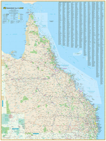
For road-tripping, sales planning, classroom display, or wall décor. Queensland touring maps come folded (1:1.4 million to 1:2 million scale) for glove-box use, or laminated as wall maps in standard (700×1000mm), Supermap (1000×1430mm) and Megamap formats. Hema's Queensland State Map is the standard reference for touring; the Hema Queensland Supermap is the most popular wall-map format.
4WD & Outback Maps
Hema dominates this category with regional 4WD-focused maps for Cape York, the Channel Country, Outback Queensland, and the Western Outback. The Cape York Atlas & Guide is the definitive trip-planning resource for that journey. For coastal 4WD, Fraser Island (K'gari) and the Sunshine Coast hinterland have dedicated regional maps.
Topographic Maps
Queensland's topographic mapping is published by the Department of Resources at 1:25k, 1:50k and 1:100k scales — the standard for bushwalking, orienteering, emergency services and detailed terrain navigation. Mapworld stocks the full QTopo printed range plus paper, waterproof Tyvek and laminated formats. For broader-scale topographic coverage, the Geoscience Australia 1:250k AUSTopo series covers the whole state.
Postcode & LGA Maps
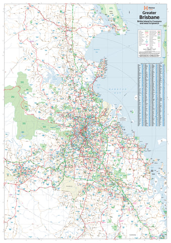
Postcode and Local Government Area wall maps are essential tools for real estate agents, sales teams, marketing analysts and government planners. Mapworld carries Brisbane, Gold Coast, Sunshine Coast, Cairns and full-state Queensland postcode maps in laminated wall format, plus dedicated LGA wall maps showing every council boundary across Queensland.
Marine & Nautical Charts
Queensland's coast is covered by official AUS-numbered Australian Hydrographic Service charts plus state Department of Agriculture and Fisheries inshore boating charts. Standout sheets: AUS 252 Whitsunday Group, AUS 236 Moreton Bay, AUS 246 Hervey Bay. All charts are corrected to the latest Notices to Mariners at time of dispatch.
Choosing the Right Queensland Map by Region
| Region | Recommended map |
|---|---|
| Cape York Peninsula | Hema Cape York Atlas & Guide + Cape York folded touring map |
| Whitsundays / GBR sailing | AUS 252 Whitsunday Group nautical chart + Hema North Queensland |
| Outback Queensland (Channel Country, Diamantina) | Hema Outback Queensland regional map + Great Desert Tracks Eastern Sheet |
| Brisbane / Gold Coast / Sunshine Coast | UBD 462 Brisbane Suburban map + Hema Greater Brisbane |
| Fraser Island (K'gari) | Fraser Island map by Hema (10th edition) |
| Atherton Tablelands / Cairns hinterland | Hema North Queensland + Cairns regional |
| Sales / real estate / planning | Queensland Postcode wall map + LGA wall map |
| Bushwalking / national parks | QTopo 1:25k or 1:50k sheets for the specific area |
Why Buy Queensland Maps from Mapworld
- Australia's largest specialist map range — over 200 Queensland-specific products in stock
- Current editions only — we rotate stock with each new release; product pages show edition year
- Free shipping over $75 Australia-wide, flat $7 below that, fast Perth dispatch
- Custom and branded mapping — postcode overlays, sales territories, healthcare catchments, mining tenements
- Knowledgeable support — speak to our team on 1300 795 697 for trip-planning or product advice
Frequently Asked Questions
What's the best map for a Cape York 4WD trip?
The Hema Cape York Atlas & Guide is the comprehensive trip-planning resource. For in-vehicle navigation, pair it with the Cape York folded touring map (current 15th edition). For wall-mounted planning at home, the laminated Cape York wall map.
Are these the latest editions of Queensland maps?
Yes. Mapworld stocks current editions only. Each product page lists the edition number and publication year. When publishers release new editions, we rotate stock to the new version.
Do you ship Queensland maps interstate?
Yes — Mapworld ships Australia-wide from our Perth warehouse. Free shipping on orders over $75, flat $7 below that. Most metro deliveries arrive in 2–5 business days. Express options available at checkout.
Can I get a custom Queensland postcode or sales-territory map?
Yes. Mapworld runs a custom mapping service for businesses needing branded or modified Queensland maps — postcode and electoral overlays, sales-territory colouring, healthcare service catchments, mining tenement and resources maps, fleet planning maps and more.
What's the difference between Hema and Department of Resources QTopo maps?
Hema produces touring-scale maps (1:550k–1:2m) with road, track and trip-planning data — ideal for road-tripping, 4WD and caravan travel. Queensland Department of Resources QTopo maps are detailed topographic sheets (1:25k–1:100k) with contour, terrain and feature data — ideal for bushwalking, orienteering and emergency services. Most travelling Queenslanders own both.
How quickly does Mapworld dispatch Queensland map orders?
Orders placed before 2 pm AWST on weekdays dispatch same-day from our Perth warehouse. Australia-wide delivery typically takes 2–7 business days via Australia Post.
For real estate, sales or service-area planning across [State Name], see our laminated [State Name] postcode wall map.
© 2026 Mapworld. Website designed by Genie Media
X