- Australia ▾
- Topographic
▾
- Australia AUSTopo 250k (2025)
- Australia 50k Geoscience maps
- Australia 100k Geoscience maps
- Australia 250k Geoscience maps
- Australia 1:1m Geoscience maps
- New Zealand 50k maps
- New Zealand 250k maps
- New South Wales 25k maps
- New South Wales 50k maps
- New South Wales 100k maps
- Queensland 10k maps
- Queensland 25k maps
- Queensland 50k maps
- Queensland 100k maps
- Western Australia 25k maps
- Western Australia 50k maps
- Western Australia 100k maps
- Compasses
- Software
- GPS Systems
- International ▾
- Wall Maps
▾
- World
- Australia & New Zealand
- Countries, Continents & Regions
- Historical
- Vintage National Geographic
- Australian Capital Territory
- New South Wales
- Northern Territory
- Queensland
- South Australia
- Tasmania
- Victoria
- Western Australia
- Celestial
- Children's
- Mining & Resources
- Wine Maps
- Healthcare
- Postcode Maps
- Electoral Maps
- Nautical ▾
- Flags
▾
- Australian Flag Sets & Banners
- Flag Bunting
- Handwavers
- Australian National Flags
- Aboriginal Flags
- Torres Strait Islander Flags
- International Flags
- Flagpoles & Accessories
- Australian Capital Territory Flags
- New South Wales Flags
- Northern Territory Flags
- Queensland Flags
- South Australia Flags
- Tasmania Flags
- Victoria Flags
- Western Australia Flags
- Gifts ▾
- Globes ▾
Dear valued customer. Please note that our checkout is not supported by old browsers. Please use a recent browser to access all checkout capabilities


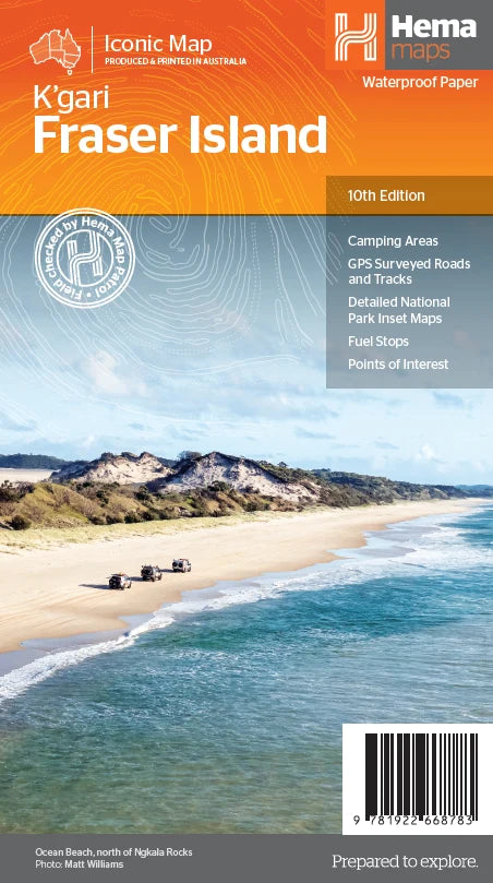
Fraser Island (K’gari) Map by Hema Maps – 10th Edition
$14.95
Afterpay is only available for orders between $50.00 and $1000.00 More info
The Definitive Map for Exploring the World's Largest Sand Island
Field-checked. Indigenous-respected. Adventure-ready.
Fraser Island, now officially known as K’gari (pronounced Gurri), is unlike anywhere else on Earth. This UNESCO World Heritage-listed marvel off the Queensland coast is a place of windswept beaches, rust-stained shipwrecks, crystal-clear lakes, rainforest canopies—and deep cultural heritage. Whether you're traversing its famous 75 Mile Beach by 4WD, hiking its sandy forest trails, or camping beneath starlit skies, this map is your most reliable companion.
Created and regularly updated by the experts at Hema Maps, this 10th edition has been meticulously GPS-surveyed and field-checked by the Hema Map Patrol to ensure accuracy, reliability, and clarity—even in the remotest pockets of the island.
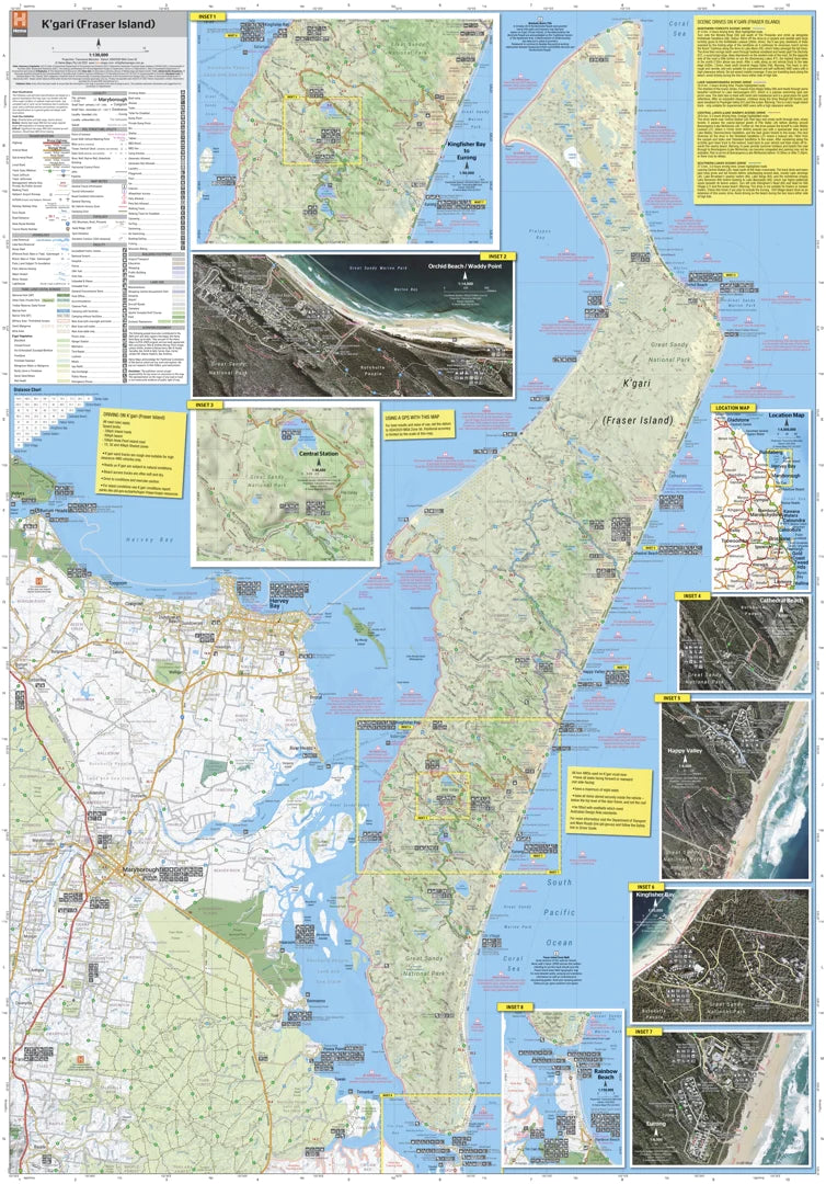
🗺️ Map Features at a Glance
🚙 4WD Track Coverage
-
All major sand tracks and inland routes surveyed and rated
-
Includes track surfaces, difficulty ratings, and distance markers
-
Highlights iconic routes:
-
75 Mile Beach
-
Sandy Cape Track
-
Inland rainforest tracks
-
Cross-island connectors like Central Station and Lake McKenzie
-
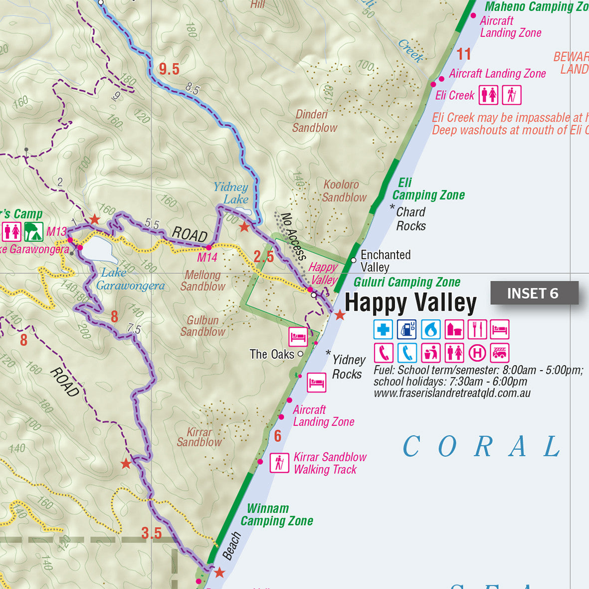
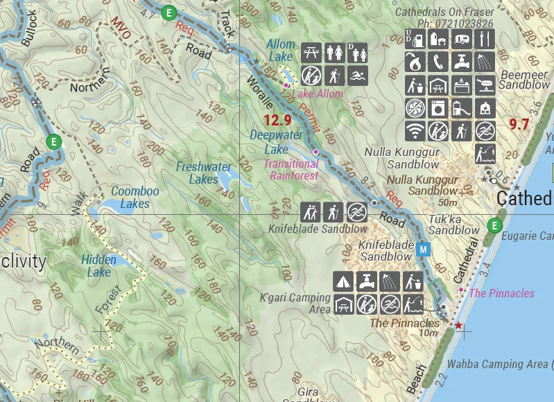
🛰️ Hybrid Topo-Satellite Insets
-
Zoomed-in mapping of key localities:
-
Waddy Point
-
Orchid Beach
-
Happy Valley
-
Eurong
-
Kingfisher Bay
-
Cathedral Beach
-
-
Combines topographic detail with satellite imagery—ideal for terrain identification and navigation around landmarks
🏕️ Camping, Navigation & Safety Tools
-
Campgrounds, day-use areas, and picnic sites clearly marked
-
Icons for:
-
Toilets 🚻
-
Fuel ⛽
-
Water access 💧
-
Barge landings ⛴️
-
Emergency contacts 🚑
-
-
Safety notes on:
-
Beach driving etiquette
-
Tyre pressure recommendations
-
Tide times and vehicle precautions
-
-
Includes camping permit zones and National Park regulations
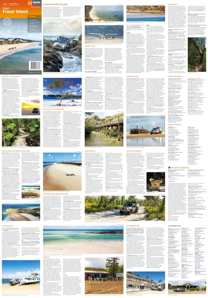
📘 Touring Guide on Reverse Side
-
Covers everything from island highlights to cultural sensitivity guidelines
-
Introduction to the Butchulla people, Traditional Owners of K’gari
-
Details on the Fraser Island Great Walk, an 84 km wilderness hiking journey
-
Regional highlights, geology, wildlife, and key ecological zones
📏 Specifications
| Feature | Details |
|---|---|
| Scale | 1:130,000 |
| Edition | 10th |
| Publication Date | May 2023 |
| Flat Size | 1000 mm × 700 mm |
| Folded Size | 140 mm × 250 mm |
| Material | Waterproof, tear-resistant synthetic paper |
| Optional Lamination | Laminated between two sheets of 80-micron gloss laminate – perfect for marking trips with whiteboard pens or map dots |
🌿 About K’gari
“K’gari” means "paradise" in the Butchulla language—an apt name for an island of clear lakes, coloured sand cliffs, and ancient rainforest growing entirely on sand.
Island Highlights:
-
💧 Lake McKenzie (Boorangoora) – One of the clearest freshwater lakes on Earth
-
🚗 SS Maheno Shipwreck – A haunting relic beached in the sand dunes
-
🏞️ Eli Creek – A freshwater stream perfect for floating or paddling
-
🌳 Rainforest Valleys – Walk among towering satinay trees and strangler figs
-
🐾 Wild Dingoes (Wongari) – K’gari’s native canines, best admired from a distance
✅ Ideal For
-
🛻 4WD Travellers tackling sand tracks and tidal zones
-
🥾 Bushwalkers & hikers exploring the Fraser Island Great Walk
-
⛺ Campers & caravanners planning long stays or coastal stops
-
📸 Nature photographers and eco-tourists chasing untouched beauty
-
🧒 Education groups exploring Indigenous culture and environmental science
-
🧭 Tour guides and travel planners creating detailed itineraries
💬 Why Choose the Hema Fraser Island Map?
✔️ Field-tested accuracy by the Hema Map Patrol
✔️ Includes insights you won’t get from GPS, like hidden camp zones and cultural notes
✔️ Printed on weatherproof, durable synthetic stock
✔️ Combines navigation, safety, and storytelling in one compact format
✔️ Trusted by rangers, explorers, and locals alike
📦 Optional Laminated Upgrade
For travellers who want a long-lasting planning tool, this map can be supplied fully laminated.
Encapsulated in two sheets of premium 80-micron gloss laminate, it's:
-
🧽 Wipeable
-
💪 Durable
-
🖊️ Writable (using whiteboard markers)
-
🧳 Perfect for years of outback use in caravans, 4WDs, or on campground tables
🏕️ Go Further with Confidence
Whether you're discovering K’gari for the first time or returning to its sandy shores, the Hema Fraser Island Map – 10th Edition ensures you’re well-prepared, well-informed, and inspired to tread lightly on this extraordinary land.
Travel smart. Travel safe. Travel with Hema.
Frequently Asked Questions
What does the Fraser Island (K’gari) Map by Hema Maps – 10th Edition cover?
The Fraser Island (K’gari) Map by Hema Maps – 10th Edition covers 4WD tracks, camping areas, and travel routes for the region described in the product title. Most 4WD and camping guides in Mapworld's range include GPS coordinates, distance information, difficulty ratings, and notes on fuel stops and emergency contact points.
Is the Fraser Island (K’gari) Map by Hema Maps – 10th Edition up to date?
Yes, this is the current edition. Mapworld stocks current editions from publishers including Hema Maps, Westprint, and others.
Is this product suitable for remote area travel?
Yes, 4WD maps and guides are designed for remote area navigation and trip planning. They include track conditions, fuel availability, camping spots, and safety information.
Does Mapworld ship the Fraser Island (K’gari) Map by Hema Maps – 10th Edition across Australia?
Yes, Mapworld ships Australia-wide. Standard shipping is a flat $7 rate, with free standard shipping on orders over $75. Express options are available at checkout. Most orders placed before 2pm AEST on weekdays are dispatched same day.
Related Items

© 2026 Mapworld. Website designed by Genie Media
X