- Australia ▾
- Topographic
▾
- Australia AUSTopo 250k (2025)
- Australia 50k Geoscience maps
- Australia 100k Geoscience maps
- Australia 250k Geoscience maps
- Australia 1:1m Geoscience maps
- New Zealand 50k maps
- New Zealand 250k maps
- New South Wales 25k maps
- New South Wales 50k maps
- New South Wales 100k maps
- Queensland 10k maps
- Queensland 25k maps
- Queensland 50k maps
- Queensland 100k maps
- Compasses
- Software
- GPS Systems
- Orienteering
- International ▾
- Wall Maps
▾
- World
- Australia & New Zealand
- Countries, Continents & Regions
- Historical
- Vintage National Geographic
- Australian Capital Territory
- New South Wales
- Northern Territory
- Queensland
- South Australia
- Tasmania
- Victoria
- Western Australia
- Celestial
- Children's
- Mining & Resources
- Wine Maps
- Healthcare
- Postcode Maps
- Electoral Maps
- Nautical ▾
- Flags
▾
- Australian Flag Sets & Banners
- Flag Bunting
- Handwavers
- Australian National Flags
- Aboriginal Flags
- Torres Strait Islander Flags
- International Flags
- Flagpoles & Accessories
- Australian Capital Territory Flags
- New South Wales Flags
- Northern Territory Flags
- Queensland Flags
- South Australia Flags
- Tasmania Flags
- Victoria Flags
- Western Australia Flags
- Gifts ▾
- Globes ▾
Dear valued customer. Please note that our checkout is not supported by old browsers. Please use a recent browser to access all checkout capabilities


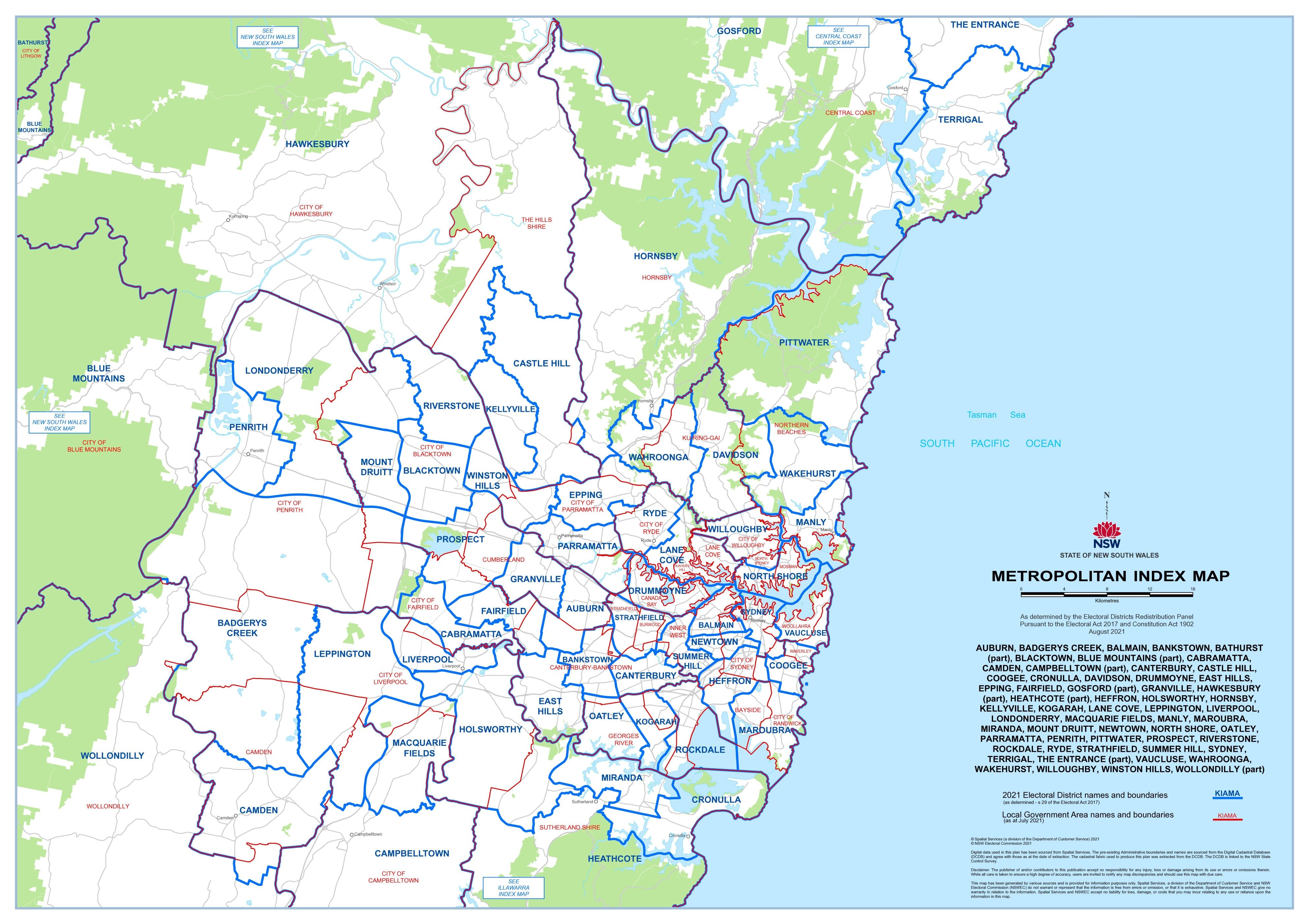
New South Wales State Electoral Divisions and Local Government Areas Map - METROPOLITAN SYDNEY
$69.95
or make 4 interest-free payments of
$17.49 AUD
fortnightly with
![]() More info
More info
New South Wales — State Electoral Divisions & Local Government Areas Map (Metropolitan Sydney)
The Metropolitan Sydney Electoral & Local Government Areas Map is your most comprehensive reference to the city’s complex political and administrative landscape. Designed for accuracy and readability, this large-format wall map is indispensable for government offices, campaign teams, schools, libraries, businesses, and community organisations.
With over 70 key divisions and LGAs, this map makes navigating Sydney’s boundaries clear and accessible for planning, strategy, and education.
🗝️ Key Features
-
Electoral divisions — Current NSW state divisions clearly labelled and delineated
-
LGA boundaries — All local government areas within Metropolitan Sydney shown
-
Extensive coverage — From Pittwater and Vaucluse in the east to Penrith and Londonderry in the west
-
Professional clarity — Fine detail and high readability in a large, practical format
-
Custom options — Individual division maps available on request
🗺️ Coverage Includes
This map covers 70+ electoral divisions and LGAs, including but not limited to:
Auburn, Badgerys Creek, Balmain, Bankstown, Blacktown, Blue Mountains (part), Cabramatta, Camden, Campbelltown (part), Canterbury, Castle Hill, Coogee, Cronulla, Davidson, Drummoyne, East Hills, Epping, Fairfield, Granville, Hawkesbury (part), Heathcote (part), Heffron, Holsworthy, Hornsby, Kellyville, Kogarah, Lane Cove, Leppington, Liverpool, Londonderry, Macquarie Fields, Manly, Maroubra, Miranda, Mount Druitt, Newtown, North Shore, Oatley, Parramatta, Penrith, Pittwater, Prospect, Riverstone, Rockdale, Ryde, Strathfield, Summer Hill, Sydney, Terrigal (part), The Entrance (part), Vaucluse, Wahroonga, Wakehurst, Willoughby, Winston Hills, Wollondilly (part).
🎨 Materials & Finishes
Choose from a range of premium finishes tailored to your use:
📄 Heavyweight Paper (160 gsm Matte)
-
Archival-quality, glare-free stock
-
Smooth matte surface preserves fine linework and colours
-
Ideal for framing under glass in offices, libraries, and classrooms
💧 Laminated (True Encapsulation)
-
Sealed in 2 × 80-micron gloss laminate
-
Waterproof, tear-resistant, and stain-protected
-
Wipe-clean surface — perfect for campaign strategy, planning, or classroom use
🪵 Laminated + Timber Hang Rails
-
Laminated map professionally mounted with natural timber rails (lacquered finish)
-
Includes strong top hanging cord for effortless wall display
-
⚠️ Please allow up to 10 working days for delivery with hang rails attached
🎨 Archival Canvas (395 gsm HP Professional Matte)
-
Printed on museum-grade canvas for a refined, textured finish
-
Pigment-based, fade-resistant inks ensure long-term clarity
-
Ideal for boardrooms, galleries, or decorative display
🪵 Canvas + Timber Hang Rails
-
Canvas map fitted with lacquered timber battens and top cord
-
A gallery-ready presentation, elegant and durable
-
⚠️ Allow up to 10 working days for delivery with hang rails attached
📐 Size
-
1000 mm × 700 mm (39.3" × 27.5")
-
Orientation: Landscape
📊 Specifications
| Attribute | Details |
|---|---|
| Title | NSW State Electoral Divisions & Local Government Areas Map – Metropolitan Sydney |
| Coverage | Metropolitan Sydney – 70+ state electoral divisions and LGAs |
| Features | Electoral division boundaries, LGA boundaries, suburb labels |
| Print Size | 1000 mm × 700 mm |
| Format Options | Paper, Laminated, Laminated + Timber Hang Rails, Canvas, Canvas + Timber Hang Rails |
| Paper Weight | 160 gsm archival matte |
| Laminate | 2 × 80-micron gloss (true encapsulation) |
| Canvas | 395 gsm HP Professional Matte |
| Inks | Pigment-based, fade-resistant |
| Optional Hang Rails | Natural timber, lacquered; top cord; allow 10 working days |
| Origin | Printed in Australia |
🎯 Who it’s for
-
🏛️ Government & electoral offices — keep boundaries clear for planning and reference
-
🗳️ Political campaign teams — plan outreach and resource allocation with accuracy
-
🎓 Schools & universities — teach civics, geography, and political science with clarity
-
🏢 Businesses & planners — understand service areas and council boundaries
-
📍 Community groups — advocacy and local planning with reliable references
🤝 Our Commitment
Each electoral map is printed and finished locally in Australia with archival-grade materials and fade-resistant inks. Every copy is colour-managed, hand-checked, and carefully packed, ensuring professional presentation and long-lasting durability.
🛒 Order your NSW State Electoral Divisions & Local Government Areas Map (Metropolitan Sydney) today — the clearest, most comprehensive guide to Sydney’s political and administrative boundaries.
Frequently Asked Questions
Where can I buy the New South Wales State Electoral Divisions and Local Government Areas M?
The New South Wales State Electoral Divisions and Local Government Areas M is available to buy online from Mapworld, Australia's largest map and geographic product retailer, with fast shipping Australia-wide.
Is the New South Wales State Electoral Divisions and Local Government Areas M in stock at Mapworld?
Mapworld maintains extensive stock across its map range and aims for fast dispatch. Orders placed before 2pm AEST on business days are typically dispatched the same day, with standard and express Australia-wide delivery options available.
What is Mapworld's returns policy?
Mapworld accepts returns on undamaged items in original condition. Contact Mapworld within 90 days of purchase to arrange a return or exchange.
Does Mapworld ship the New South Wales State Electoral Divisions and Local Government Areas M across Australia?
Yes, Mapworld ships Australia-wide. Standard shipping is a flat $7 rate, with free standard shipping on orders over $75. Express options are available at checkout. Most orders placed before 2pm AEST on weekdays are dispatched same day.
Related Items

© 2026 Mapworld. Website designed by Genie Media
X