- Australia ▾
- Topographic
▾
- Australia AUSTopo 250k (2024)
- Australia 50k Geoscience maps
- Australia 100k Geoscience maps
- Australia 250k Geoscience maps
- Australia 1.1m Geoscience maps
- New Zealand 50k maps
- New Zealand 250k maps
- New South Wales 25k maps
- New South Wales 50k maps
- New South Wales 100k maps
- Queensland 10k maps
- Queensland 25k maps
- Queensland 50k maps
- Queensland 100k maps
- Compasses
- Software
- GPS Systems
- Orienteering
- International ▾
- Wall Maps
▾
- World
- Australia & New Zealand
- Countries, Continents & Regions
- Historical
- Vintage National Geographic
- Australian Capital Territory
- New South Wales
- Northern Territory
- Queensland
- South Australia
- Tasmania
- Victoria
- Western Australia
- Celestial
- Children's
- Mining & Resources
- Wine Maps
- Healthcare
- Postcode Maps
- Electoral Maps
- Nautical ▾
- Flags
▾
- Australian Flag Sets & Banners
- Flag Bunting
- Handwavers
- Australian National Flags
- Aboriginal Flags
- Torres Strait Islander Flags
- International Flags
- Flagpoles & Accessories
- Australian Capital Territory Flags
- New South Wales Flags
- Northern Territory Flags
- Queensland Flags
- South Australia Flags
- Tasmania Flags
- Victoria Flags
- Western Australia Flags
- Gifts ▾
- Globes ▾
Dear valued customer. Please note that our checkout is not supported by old browsers. Please use a recent browser to access all checkout capabilities
Rotorua Historic Wall Map 1966
$69.95
or make 4 interest-free payments of
$17.49 AUD
fortnightly with
![]() More info
More info
Vintage New Zealand Cartography | Heritage Reproduction | Premium Finishes
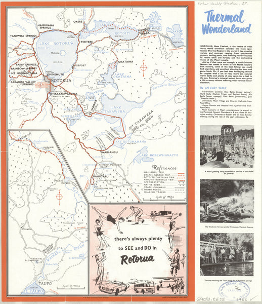
Experience Rotorua as it was in 1966 with this beautifully reproduced historical map, originally created by the New Zealand Department of Lands and Survey. Famous for its geothermal wonders, lakes, and rich Māori cultural heritage, Rotorua is presented here in exquisite cartographic detail from a mid-20th century perspective — making it a captivating piece for both history lovers and interior decorators.
📜 Historical Highlights
-
Authentic 1966 Cartography – A faithful reproduction showing roads, railways, settlements, lakes, geothermal features, and surrounding landscapes as they were over half a century ago.
-
Mid-Century Design – Retains the original typography, layout, and colour scheme characteristic of New Zealand maps of the era.
-
Cultural & Geographic Significance – Offers a unique insight into Rotorua’s geography before the modern tourism boom.
📐 Specifications
| Feature | Detail |
|---|---|
| Title | Rotorua Historic Wall Map – 1966 |
| Original Publisher | New Zealand Department of Lands and Survey |
| Year Published | 1966 |
| Reproduction Size | 910 mm (W) x 210 mm (H) |
| Materials | 160 gsm matte-coated paper / 80-micron gloss laminate / 395 gsm HP Professional Matte Canvas |
| Origin | Printed and finished in Australia |
✨ Available Finishes
| Format | Description |
|---|---|
| 🖨️ Paper (160 gsm) | Heavyweight matte-coated paper — ideal for framing under glass. |
| 🧼 Laminated (Encapsulated) | Fully sealed between two sheets of 80-micron gloss laminate for durability and water-resistance. |
| 🪵 Laminated with Wooden Hang Rails | Laminated map mounted with natural lacquered timber rails (top & bottom) and a hanging cord — ready to hang. |
| 🖼️ Canvas (395 gsm) | Printed on archival-quality HP Professional Matte Canvas with pigment-based inks — fade-resistant and richly textured. |
| 🪵 Canvas with Wooden Hang Rails | Canvas map mounted with natural timber rails and hanging cord — a true heritage display piece. |
🔨 Please allow up to 10 working days for delivery of hang-railed maps, as they are professionally mounted by our framer.
💡 Why You’ll Love This Map
✔️ Authentic mid-century depiction of Rotorua
✔️ Decorative yet historically informative
✔️ Available in archival paper, laminated, or premium canvas formats
✔️ Makes a perfect heritage display piece for home or office
✔️ A meaningful gift for New Zealand history enthusiasts
🎯 Perfect For
-
Collectors of New Zealand Cartography – Add an authentic mid-century map to your collection
-
Interior Design with Character – Bring a slice of Rotorua’s past to your walls
-
Educational Use – Ideal for schools, libraries, and museums
-
Gifting – A thoughtful present for those with ties to Rotorua
The Rotorua Historic Wall Map – 1966 is more than a map — it’s a window into a moment in time, celebrating the rich heritage and landscape of one of New Zealand’s most famous regions.
👉 Select your preferred finish above and bring this vintage classic to life in your space.


