A Piece of New Zealand’s Cartographic Heritage, Beautifully Crafted for Your Wall
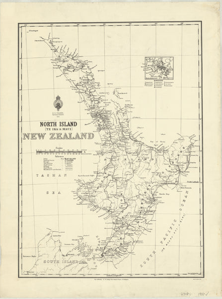
Step into the past with this 1937 vintage map of New Zealand’s North Island, meticulously reproduced from the original publication by the Department of Lands and Survey. This map not only preserves the rich historical detail of the period, but also comes in a range of premium finishes to suit every setting—from elegant home décor to durable classroom reference.
🗺️ About the Map
-
Historic significance: This map captures the geography, settlements, and infrastructure of New Zealand’s North Island as they appeared in 1937—a valuable resource for historians, educators, and enthusiasts alike.
-
Authenticity assured: Reproduced from the authoritative records of New Zealand’s Department of Lands and Survey, ensuring accuracy and historical fidelity.
-
Timeless design: Period fonts, classic colour palettes, and clean linework make this map as visually striking as it is informative.
✅ Finishes & Materials
Whether you’re displaying this map as an elegant centrepiece, using it in the classroom, or preserving it in a collection, our range of finishes ensures the perfect fit:
📜 160 gsm FSC Matte-Coated Paper
-
Smooth matte finish: Minimises glare while highlighting fine cartographic details.
-
Archival-quality: FSC-certified stock is ideal for conservation and framing behind glass, where it remains protected and pristine.
-
Perfect for collectors: Offers a classic look and feel that honours the map’s historic origins.
🛡️ Encapsulated Laminate Version
-
Durable gloss finish: The map is printed on 120 gsm paper, then encapsulated between two layers of 80-micron gloss laminate, creating a sturdy, wipeable surface.
-
Practical & reusable: Great for classrooms, offices, and workshops—simply mark with whiteboard markers and wipe clean.
-
Protects against wear: Resists tearing, moisture, and fingerprints, making it an excellent choice for high-traffic environments.
- Optional hang rails: Select wooden hang rollers in a natural timber finish, lacquered for protection and fitted with a hanging cord. No need for framing—simply hang on a hook and enjoy.
🖼️ 395 gsm HP Professional Matte Canvas
-
Gallery-quality presentation: Printed on heavy-duty 395 gsm HP Professional Matte Canvas using archival-grade pigment-based inks that offer rich colour depth and exceptional fade resistance.
-
Premium texture: The canvas surface brings depth and warmth, turning this historic map into a stunning visual feature.
-
Optional hang rails: Select wooden hang rollers in a natural timber finish, lacquered for protection and fitted with a hanging cord. No need for framing—simply hang on a hook and enjoy.
-
Ready to impress: Ideal for boardrooms, libraries, heritage centres, or any space that calls for elegant, museum-quality display.
📐 Specifications
| Attribute | Details |
|---|---|
| Title | North Island Historic Wall Map |
| Published | 1937 |
| Source | New Zealand Department of Lands and Survey |
| Size | 950 mm (W) x 707 mm (H) |
| Material options | 160 gsm matte paper, laminated (80-micron gloss), or canvas (395 gsm HP Professional Matte) |
| Printing | Pigment-based inks for archival-quality clarity and fade resistance |
| Delivery | Made in Australia—allow 7-10 working days for hang-railed versions |
🎯 Why Choose This Map?
| Feature | Benefit |
|---|---|
| Multiple finishes | Choose paper for traditional framing, laminate for durability, or canvas for elegant ready-to-hang display |
| Archival-grade printing | Long-lasting clarity and colour that resists fading over time |
| Practical & decorative | Suitable for reference, teaching, or as beautiful wall art |
| Crafted with care | Every map printed and finished in Australia to the highest standards |
| Easy installation | Canvas with optional hang rails offers instant, effortless hanging |
Select your preferred finish and bring this historic glimpse of New Zealand’s North Island into your home, office, or collection today. Crafted with care, made to last, and sure to inspire.


