- Australia ▾
- Topographic
▾
- Australia AUSTopo 250k (2025)
- Australia 50k Geoscience maps
- Australia 100k Geoscience maps
- Australia 250k Geoscience maps
- Australia 1:1m Geoscience maps
- New Zealand 50k maps
- New Zealand 250k maps
- New South Wales 25k maps
- New South Wales 50k maps
- New South Wales 100k maps
- Queensland 10k maps
- Queensland 25k maps
- Queensland 50k maps
- Queensland 100k maps
- Compasses
- Software
- GPS Systems
- Orienteering
- International ▾
- Wall Maps
▾
- World
- Australia & New Zealand
- Countries, Continents & Regions
- Historical
- Vintage National Geographic
- Australian Capital Territory
- New South Wales
- Northern Territory
- Queensland
- South Australia
- Tasmania
- Victoria
- Western Australia
- Celestial
- Children's
- Mining & Resources
- Wine Maps
- Healthcare
- Postcode Maps
- Electoral Maps
- Nautical ▾
- Flags
▾
- Australian Flag Sets & Banners
- Flag Bunting
- Handwavers
- Australian National Flags
- Aboriginal Flags
- Torres Strait Islander Flags
- International Flags
- Flagpoles & Accessories
- Australian Capital Territory Flags
- New South Wales Flags
- Northern Territory Flags
- Queensland Flags
- South Australia Flags
- Tasmania Flags
- Victoria Flags
- Western Australia Flags
- Gifts ▾
- Globes ▾
Dear valued customer. Please note that our checkout is not supported by old browsers. Please use a recent browser to access all checkout capabilities


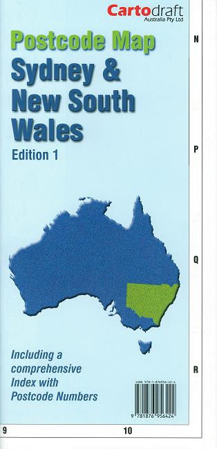
Sydney & New South Wales Folded Postcode Map
$69.95
or make 4 interest-free payments of
$17.49 AUD
fortnightly with
![]() More info
More info
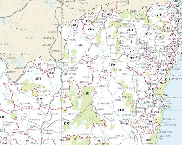
Available as either a Sydney Postcode Map or a New South Wales Postcode Map — each supplied as an individual single-sided folded map for fast, practical reference.
A dependable postcode reference designed for businesses, planners, transport operators, and organisations that rely on accurate postcode boundaries every day. Whether you are coordinating deliveries across metropolitan Sydney, managing statewide service areas, planning direct-mail campaigns, or allocating sales territories, these professionally produced postcode maps from Cartodraft provide a clear and efficient way to visualise postcode regions at a glance.
Importantly, these are not double-sided maps. Each edition is supplied as its own dedicated single-sided folded map, allowing you to choose the exact coverage you need:
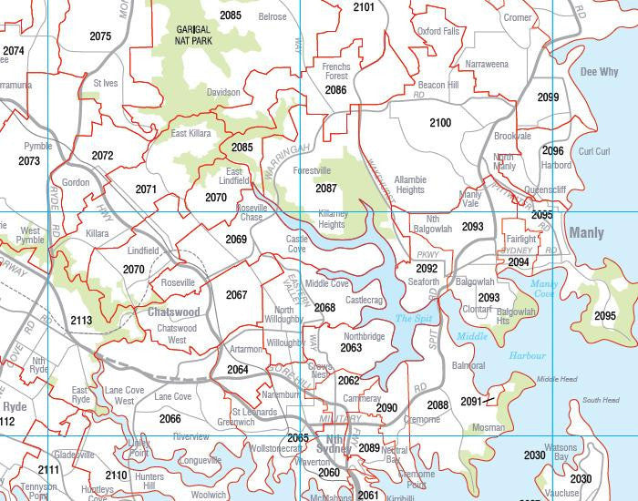
- Sydney Postcode Map — detailed coverage of Greater Sydney and surrounding metropolitan areas
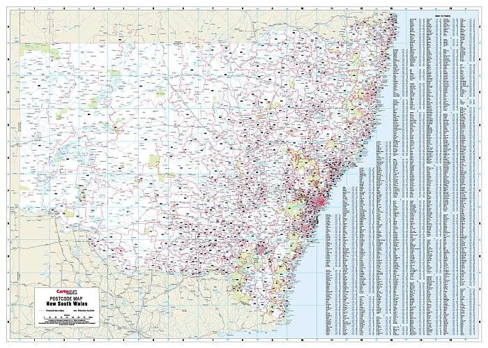
- New South Wales Postcode Map — comprehensive statewide postcode coverage including regional centres, coastal towns, inland communities, and major transport corridors
This single-sided format provides a far more user-friendly experience for offices, dispatch teams, warehouses, and meeting rooms, as the entire map can be viewed at once without needing to constantly flip between sides.
🗺️ Why These Maps Work So Well
In many businesses, postcode boundaries are critical operational information. From transport routing and delivery zones to franchise territories and demographic planning, having a large-format postcode reference visible and easy to interpret can save time, reduce confusion, and improve planning accuracy.
These maps have been designed specifically for practical business use — combining clarity, detail, and ease of navigation in a straightforward folded format that is ready to use immediately.
🔍 Key Features
📌 Clearly Defined Postcode Boundaries
Every postcode area is clearly outlined and labelled, making it easy to identify service regions, delivery areas, and postcode divisions quickly and accurately.
🧭 Choose the Coverage You Need
Two separate editions are available:
Sydney Edition
Focused metropolitan detail covering Greater Sydney and surrounding urban areas. Ideal for:
- Metro delivery operations
- Real estate offices
- Trades and service businesses
- Franchise territories
- Sales representatives
- Urban marketing campaigns
New South Wales Edition
A statewide postcode reference covering metropolitan, regional, coastal, and inland NSW. Excellent for:
- Statewide logistics
- Freight and transport companies
- Regional service planning
- Government departments
- Agricultural suppliers
- Multi-region business operations
📄 Single-Sided Layout for Easier Use
Unlike traditional double-sided postcode maps, each map is printed entirely on one side. This provides several important advantages:
- Easier wall or desk reference
- Faster postcode lookup
- No flipping between sides
- Better visibility during meetings or planning sessions
- More practical for office and dispatch environments
The single-sided design makes these maps particularly useful in high-use operational settings where speed and clarity matter.
🗂️ Complete Postcode Index Included
Each map features a comprehensive alphabetical index of towns and suburbs matched with their corresponding postcode numbers, allowing users to quickly locate locations without unnecessary searching.
The index is particularly useful for:
- Customer database verification
- Delivery planning
- Service allocation
- Territory management
- Bulk mailing preparation
🏢 Ideal for Professional & Business Use
These postcode maps are widely used across a broad range of industries and operational environments.
🚚 Logistics & Transport
Perfect for route planning, freight coordination, depot management, and delivery zone organisation.
🏘️ Real Estate & Property
A valuable office reference for agents working across multiple suburbs, postcode regions, and service territories.
📬 Marketing & Distribution
Useful for postcode-targeted campaigns, demographic planning, and distribution management.
🛠️ Trade & Service Businesses
Helps allocate technicians, crews, and contractors efficiently across operational regions.
🏢 Franchise & Territory Management
Clearly visualise postcode allocations for sales representatives, franchise zones, and regional operations.
🗺️ Government & Planning Offices
Supports administrative planning, regional servicing, and postcode-based operational work.
📐 Map Specifications
| Feature | Details |
|---|---|
| Publisher | Cartodraft |
| Available Editions | Sydney Postcode Map or New South Wales Postcode Map |
| Format | Folded, single-sided |
| Coverage | Greater Sydney or all of New South Wales |
| Size (Unfolded) | 1110 mm (W) × 788 mm (H) |
| Index | Complete alphabetical postcode index |
| Mapping Detail | Postcode boundaries and postcode numbers |
| Use Cases | Logistics, planning, marketing, territory allocation, postcode lookup |
🧳 Easy to Store. Easy to Use.
The folded format makes these maps convenient to keep on hand in:
- Offices
- Dispatch centres
- Warehouses
- Vehicles
- Sales departments
- Meeting rooms
- Reception areas
When unfolded, the generous large-format layout provides excellent readability and clear postcode visibility across the entire coverage area.
🤝 Our Commitment
Every map is supplied with a focus on practical usability, clarity, and professional presentation. At Mapworld, we understand that postcode maps are not simply reference products — they are everyday operational tools relied upon by businesses and organisations across Australia.
We carefully select mapping products that combine accuracy, readability, and real-world functionality.
📌 Stay Organised. Plan Smarter. Deliver with Confidence.
The Sydney & New South Wales Folded Postcode Maps by Cartodraft provide a fast, practical, and highly readable postcode reference for everyday business operations.
With a clear single-sided layout and the flexibility to choose either Sydney metropolitan coverage or full New South Wales statewide coverage, these maps make postcode planning simpler, faster, and more efficient.
Choose the edition that suits your operation and keep postcode information clear, accessible, and ready when you need it.
Frequently Asked Questions
What are the dimensions of the Sydney & New South Wales Folded Postcode Map?
Mapworld wall maps range from standard 700×1000mm to large-format 1000×1430mm Supermaps. The exact dimensions for this map are shown in the product title. Where multiple sizes are available, select your preferred size when adding to cart.
Is this wall map available laminated?
Many Mapworld wall maps are available in paper, laminated, or framed finishes. Check the product options when adding to cart. Laminated maps are wipe-clean and more durable.
Is this the latest edition?
Mapworld stocks the most current editions available from all publishers. Edition year is shown in the product title where applicable. Mapworld updates its catalogue as new editions are released.
Can I write on or pin this wall map?
Laminated wall maps can be written on with whiteboard markers and wiped clean. Paper maps can be pinned on a corkboard. Choose a laminated option for a writeable surface.
Does Mapworld ship the Sydney & New South Wales Folded Postcode Map across Australia?
Yes, Mapworld ships Australia-wide. Standard shipping is a flat $7 rate, with free standard shipping on orders over $75. Express options are available at checkout. Most orders placed before 2pm AEST on weekdays are dispatched same day.
Related Items


© 2026 Mapworld. Website designed by Genie Media
X