- Australia ▾
- Topographic
▾
- Australia AUSTopo 250k (2025)
- Australia 50k Geoscience maps
- Australia 100k Geoscience maps
- Australia 250k Geoscience maps
- Australia 1:1m Geoscience maps
- New Zealand 50k maps
- New Zealand 250k maps
- New South Wales 25k maps
- New South Wales 50k maps
- New South Wales 100k maps
- Queensland 10k maps
- Queensland 25k maps
- Queensland 50k maps
- Queensland 100k maps
- Compasses
- Software
- GPS Systems
- Orienteering
- International ▾
- Wall Maps
▾
- World
- Australia & New Zealand
- Countries, Continents & Regions
- Historical
- Vintage National Geographic
- Australian Capital Territory
- New South Wales
- Northern Territory
- Queensland
- South Australia
- Tasmania
- Victoria
- Western Australia
- Celestial
- Children's
- Mining & Resources
- Wine Maps
- Healthcare
- Postcode Maps
- Electoral Maps
- Nautical ▾
- Flags
▾
- Australian Flag Sets & Banners
- Flag Bunting
- Handwavers
- Australian National Flags
- Aboriginal Flags
- Torres Strait Islander Flags
- International Flags
- Flagpoles & Accessories
- Australian Capital Territory Flags
- New South Wales Flags
- Northern Territory Flags
- Queensland Flags
- South Australia Flags
- Tasmania Flags
- Victoria Flags
- Western Australia Flags
- Gifts ▾
- Globes ▾
Dear valued customer. Please note that our checkout is not supported by old browsers. Please use a recent browser to access all checkout capabilities


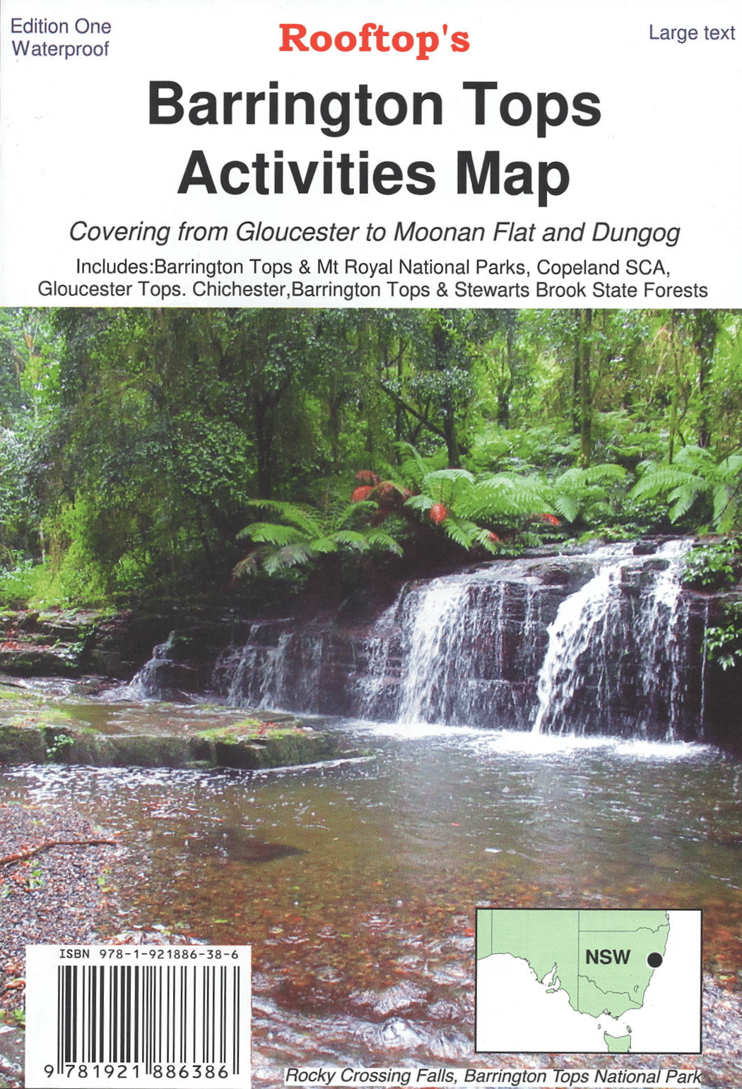
Barrington Tops Activities Rooftop Map
$15.95 $17.95
Afterpay is only available for orders between $50.00 and $1000.00 More info
🥾 Barrington Tops Activities Map – Rooftop Maps
Your ultimate companion for exploring the alpine wilderness, ancient rainforests, and rugged trails of Barrington Tops and beyond.
The Rooftop Barrington Tops Activities Map is a highly detailed, double-sided topographic map that offers the clarity, accuracy, and insight needed to explore one of New South Wales’ most spectacular highland regions. Whether you're hiking through cloud-swept plateaus, discovering hidden waterfalls, or camping beneath tall eucalypts, this map puts every landmark and trail at your fingertips.
🗺️ Coverage Areas
This map focuses on the stunning and remote wilderness of the Upper Hunter and Mid-North Coast hinterlands, including:
-
Barrington Tops National Park
-
Mt Royal National Park
-
Gloucester Tops and Copeland State Conservation Area
-
Chichester, Barrington Tops, and Stewarts Brook State Forests
From pristine alpine meadows to rainforest gullies and rugged 4WD tracks, every natural feature is carefully charted.
🔍 Map Features
-
🧭 Main Topographic Map – Scale 1:50,000
Ideal for walkers, 4WD drivers, campers, and eco-tourists seeking reliable navigation and terrain awareness. -
🌲 Detailed Inset – Gloucester Tops Walking Tracks (Scale 1:25,000)
Discover lush forest trails and waterfalls with fine-scale walking track information, perfect for bushwalkers. -
🛖 High Country Huts Information
Includes notes on historic huts scattered throughout the national park – great for heritage lovers and hikers seeking shelter. -
🚗 Roads and Tracks Mapped with GPS Accuracy
Over 5,000 km of roads and trails surveyed using GPS mapping technology to ensure dependable navigation. -
📌 Points of Interest & Facilities
Campgrounds, day-use areas, waterfalls, picnic spots, lookouts, creeks, rivers, and access gates are all clearly marked.
📐 Map Specifications
| Feature | Details |
|---|---|
| Publisher | Rooftop Maps |
| Map Title | Barrington Tops Activities Map |
| Scale (Main Map) | 1:50,000 |
| Scale (Inset) | 1:25,000 (Gloucester Tops walking trails) |
| Format | Folded, double-sided topographic map |
| Paper | Durable paper, suitable for outdoor use |
| Size | Approx. 700 mm × 1000 mm unfolded |
🧳 Ideal For:
-
🥾 Bushwalkers and hikers navigating high-country tracks
-
🚙 4WD enthusiasts exploring remote alpine routes
-
⛺ Campers and caravanners seeking backcountry sites
-
🌿 Conservationists, ecologists, and nature photographers
-
🗺️ Map collectors and outdoor educators
💡 Why Choose Rooftop’s Barrington Tops Map?
-
Created by Australia’s most trusted topographic mapmaker for adventurers
-
Precision-mapped with local knowledge and GPS verification
-
Clear depiction of elevation, contour lines, and vegetation zones
-
Includes local notes, hut history, and walking trail detail not found on general maps
🛠️ Optional Upgrade: Laminated Version
We can also laminate this map, encapsulating it in two sheets of high-quality 80-micron gloss laminate. This makes it:
-
Water-resistant and tear-proof
-
Writable with whiteboard markers for planning routes or highlighting trails
-
Durable enough for repeated use in the field
Perfect for 4WD dashboards, campsite tables, or walking trip planning.
Explore deeper, navigate smarter, and embrace the wild beauty of Barrington Tops with Rooftop's trusted map in hand.
Frequently Asked Questions
Where can I buy the Barrington Tops Activities Rooftop Map?
The Barrington Tops Activities Rooftop Map is available to buy online from Mapworld, Australia's largest map and geographic product retailer, with fast shipping Australia-wide.
Is the Barrington Tops Activities Rooftop Map in stock at Mapworld?
Mapworld maintains extensive stock across its map range and aims for fast dispatch. Orders placed before 2pm AEST on business days are typically dispatched the same day, with standard and express Australia-wide delivery options available.
What is Mapworld's returns policy?
Mapworld accepts returns on undamaged items in original condition. Contact Mapworld within 90 days of purchase to arrange a return or exchange.
Does Mapworld ship the Barrington Tops Activities Rooftop Map across Australia?
Yes, Mapworld ships Australia-wide. Standard shipping is a flat $7 rate, with free standard shipping on orders over $75. Express options are available at checkout. Most orders placed before 2pm AEST on weekdays are dispatched same day.
Related Items


© 2026 Mapworld. Website designed by Genie Media
X