- Australia ▾
- Topographic
▾
- Australia AUSTopo 250k (2025)
- Australia 50k Geoscience maps
- Australia 100k Geoscience maps
- Australia 250k Geoscience maps
- Australia 1:1m Geoscience maps
- New Zealand 50k maps
- New Zealand 250k maps
- New South Wales 25k maps
- New South Wales 50k maps
- New South Wales 100k maps
- Queensland 10k maps
- Queensland 25k maps
- Queensland 50k maps
- Queensland 100k maps
- Western Australia 25k maps
- Western Australia 50k maps
- Western Australia 100k maps
- Compasses
- Software
- GPS Systems
- International ▾
- Wall Maps
▾
- World
- Australia & New Zealand
- Countries, Continents & Regions
- Historical
- Vintage National Geographic
- Australian Capital Territory
- New South Wales
- Northern Territory
- Queensland
- South Australia
- Tasmania
- Victoria
- Western Australia
- Celestial
- Children's
- Mining & Resources
- Wine Maps
- Healthcare
- Postcode Maps
- Electoral Maps
- Nautical ▾
- Flags
▾
- Australian Flag Sets & Banners
- Flag Bunting
- Handwavers
- Australian National Flags
- Aboriginal Flags
- Torres Strait Islander Flags
- International Flags
- Flagpoles & Accessories
- Australian Capital Territory Flags
- New South Wales Flags
- Northern Territory Flags
- Queensland Flags
- South Australia Flags
- Tasmania Flags
- Victoria Flags
- Western Australia Flags
- Gifts ▾
- Globes ▾
Dear valued customer. Please note that our checkout is not supported by old browsers. Please use a recent browser to access all checkout capabilities


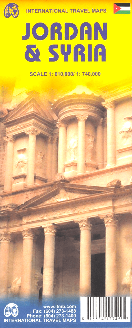
Jordan Syria ITMB Map
$24.95
Afterpay is only available for orders between $50.00 and $1000.00 More info
🗺️ Jordan & Syria Travel Map by ITMB
Double-Sided | Folded | Optional Lamination | Scale: 1:610,000 (Jordan) / 1:740,000 (Syria) | Size: 700 x 1000 mm
Explore two of the Middle East’s most historically and culturally rich nations with this expertly updated travel map by International Travel Maps (ITMB). Covering Jordan on one side and Syria on the reverse, this map is perfect for adventurous travellers, overlanders, aid workers, educators, and anyone seeking a deeper understanding of this fascinating region.
Printed in full colour with topographic relief, road networks, place names, and points of interest, this is one of the most up-to-date and comprehensive resources available for navigating Jordan and Syria.
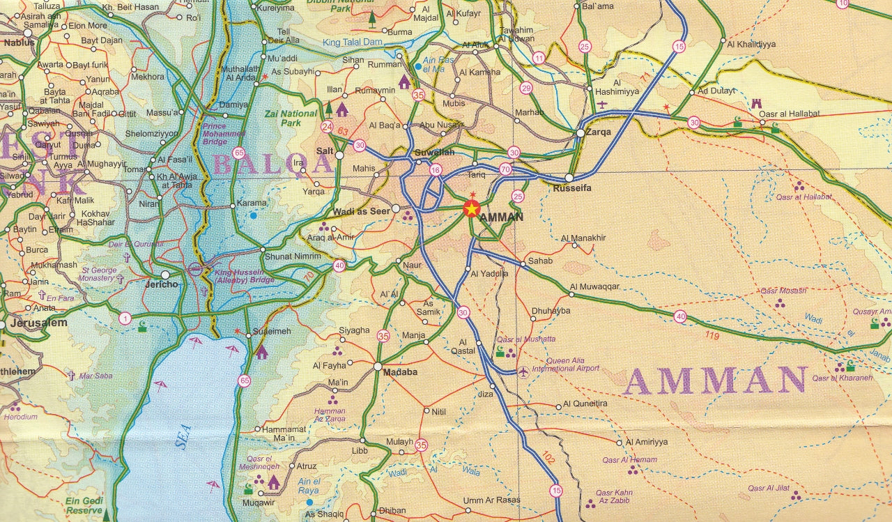
🇯🇴 Jordan Side (Scale 1:610,000)
Jordan is one of the most traveller-friendly countries in the Middle East. This side of the map features:
-
🕌 Historic & Cultural Sites – Petra, Jerash, Amman Citadel, Mount Nebo, and the Dead Sea
-
🏜️ Natural Wonders – Wadi Rum, Dana Biosphere Reserve, Mujib Canyon
-
🛣️ Transport Infrastructure – Clear road classifications, highways, secondary routes, and desert tracks
-
🧭 Tourist Essentials – Airports, border crossings, gas stations, and accommodation zones
Ideal for planning road trips, group tours, or archaeological adventures.
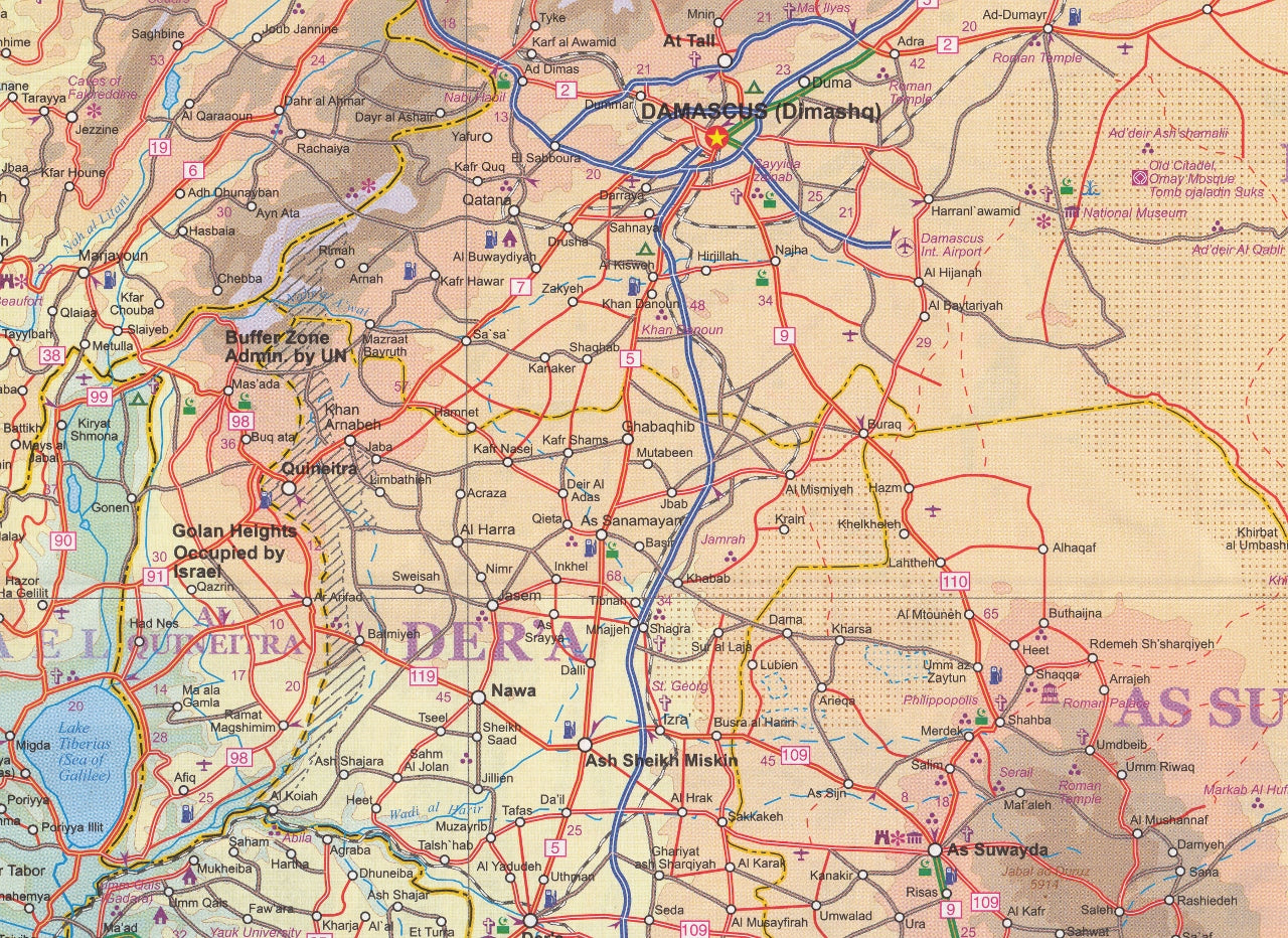
🇸🇾 Syria Side (Scale 1:740,000)
While less commonly travelled, Syria is a country of immense cultural depth and historical significance. This side includes:
-
🏰 Iconic Cities & Sites – Damascus, Aleppo, Palmyra, Krak des Chevaliers, Hama, Homs, and Latakia
-
🗺️ Heritage Routes – Biblical sites, Crusader castles, ancient Roman roads
-
🛤️ Railways & Roads – Including main road links to Lebanon, Turkey, and Iraq
-
⛩️ Cultural Detail – Mosques, churches, souks, and archaeological ruins
A valuable reference for historians, academics, and humanitarian missions operating in the region.
📌 Map Features & Highlights
-
✅ Double-sided full country coverage (Jordan/Syria)
-
✅ Topographic relief shading shows elevation and terrain
-
✅ All major roads and highways with route numbers and travel distances
-
✅ Cities, towns, and villages clearly marked
-
✅ National parks, reserves, and protected areas
-
✅ Detailed place name index
-
✅ Printed on durable paper stock for everyday travel use
💧 Laminated Version (Optional)
Upgrade to the laminated version for added durability and utility:
-
✏️ Write on/wipe off surface – Use whiteboard markers to plan routes or mark locations
-
💧 Waterproof – Ideal for use in harsh weather conditions or outdoor travel
-
💪 Tear-resistant – Reinforced with 80-micron gloss laminate to withstand frequent folding/unfolding
🔔 Note: The laminated version is created by flattening and encapsulating the folded map in high-quality gloss laminate. Fold lines will still be faintly visible.
📐 Specifications
| Feature | Details |
|---|---|
| Map Title | Jordan & Syria Travel Map by ITMB |
| Map Coverage | Jordan (Side A), Syria (Side B) |
| Scales | 1:610,000 (Jordan), 1:740,000 (Syria) |
| Map Size | 700 mm x 1000 mm |
| Format | Folded paper (optional laminated) |
| Publisher | ITMB – International Travel Maps |
| Print Type | Double-sided, full colour |
| Laminated Option | Yes – Encapsulated 80-micron gloss |
🎯 Who’s It For?
-
🌍 Adventurous travellers exploring the Middle East
-
🎒 Backpackers and overlanders seeking off-the-beaten-path adventures
-
🕍 Pilgrims and religious tourists visiting Biblical sites
-
🛠️ Aid workers & NGOs operating in Jordan and Syria
-
🧠 Educators & researchers studying geography, history, or conflict regions
-
📸 Photographers and cultural explorers documenting heritage and landscapes
This Jordan & Syria ITMB map is more than just a navigation tool — it’s a travel companion for meaningful exploration, combining practical route information with insights into ancient lands and modern dynamics. Whether you're trekking in Petra, tracing Biblical paths, or navigating the Syrian heartland, this map is an essential guide in your pocket.
Frequently Asked Questions
Where can I buy the Jordan Syria ITMB Map?
The Jordan Syria ITMB Map is available to buy online from Mapworld, Australia's largest map and geographic product retailer, with fast shipping Australia-wide.
Is the Jordan Syria ITMB Map in stock at Mapworld?
Mapworld maintains extensive stock across its map range and aims for fast dispatch. Orders placed before 2pm AEST on business days are typically dispatched the same day, with standard and express Australia-wide delivery options available.
What is Mapworld's returns policy?
Mapworld accepts returns on undamaged items in original condition. Contact Mapworld within 90 days of purchase to arrange a return or exchange.
Does Mapworld ship the Jordan Syria ITMB Map across Australia?
Yes, Mapworld ships Australia-wide. Standard shipping is a flat $7 rate, with free standard shipping on orders over $75. Express options are available at checkout. Most orders placed before 2pm AEST on weekdays are dispatched same day.
Related Items


© 2026 Mapworld. Website designed by Genie Media
X