- Australia ▾
- Topographic
▾
- Australia AUSTopo 250k (2025)
- Australia 50k Geoscience maps
- Australia 100k Geoscience maps
- Australia 250k Geoscience maps
- Australia 1:1m Geoscience maps
- New Zealand 50k maps
- New Zealand 250k maps
- New South Wales 25k maps
- New South Wales 50k maps
- New South Wales 100k maps
- Queensland 10k maps
- Queensland 25k maps
- Queensland 50k maps
- Queensland 100k maps
- Western Australia 25k maps
- Western Australia 50k maps
- Western Australia 100k maps
- Compasses
- Software
- GPS Systems
- International ▾
- Wall Maps
▾
- World
- Australia & New Zealand
- Countries, Continents & Regions
- Historical
- Vintage National Geographic
- Australian Capital Territory
- New South Wales
- Northern Territory
- Queensland
- South Australia
- Tasmania
- Victoria
- Western Australia
- Celestial
- Children's
- Mining & Resources
- Wine Maps
- Healthcare
- Postcode Maps
- Electoral Maps
- Nautical ▾
- Flags
▾
- Australian Flag Sets & Banners
- Flag Bunting
- Handwavers
- Australian National Flags
- Aboriginal Flags
- Torres Strait Islander Flags
- International Flags
- Flagpoles & Accessories
- Australian Capital Territory Flags
- New South Wales Flags
- Northern Territory Flags
- Queensland Flags
- South Australia Flags
- Tasmania Flags
- Victoria Flags
- Western Australia Flags
- Gifts ▾
- Globes ▾
Dear valued customer. Please note that our checkout is not supported by old browsers. Please use a recent browser to access all checkout capabilities


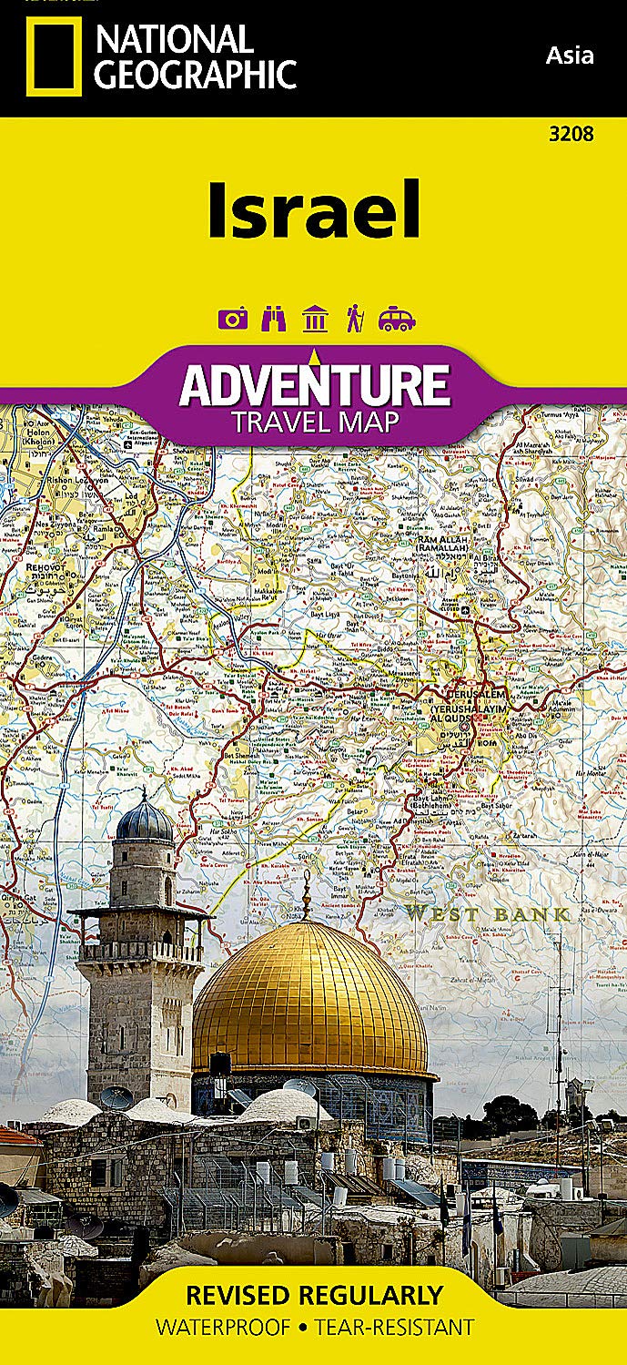
Israel National Geographic Folded Map
Sold Out
Afterpay is only available for orders between $50.00 and $1000.00 More info
Israel Adventure Travel Map – National Geographic
Waterproof | Tear-Resistant | Folded Map
Scale: 1:330,000 | Sheet Size: 965 x 660 mm | Two-Sided
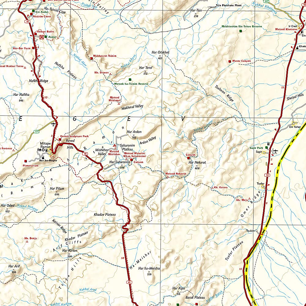
Explore the heart of the Holy Land with National Geographic’s Israel Adventure Map—a field-tested and richly detailed guide for travelers seeking to experience the historic, cultural, and natural wonders of Israel and the surrounding region. This map combines precise topographic mapping with expertly curated travel content, making it ideal for both spiritual pilgrims and adventurous explorers.
🔍 What This Map Covers
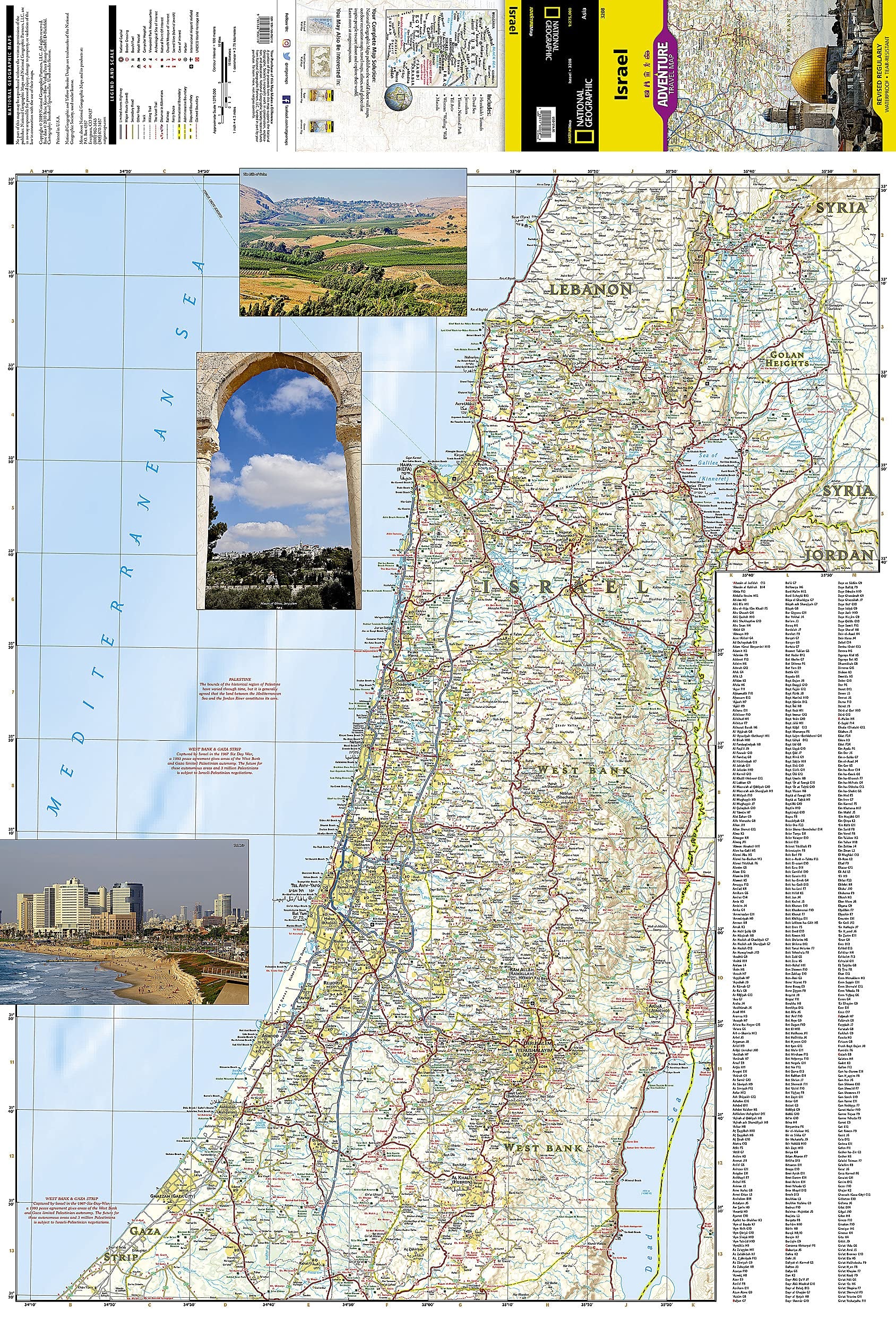
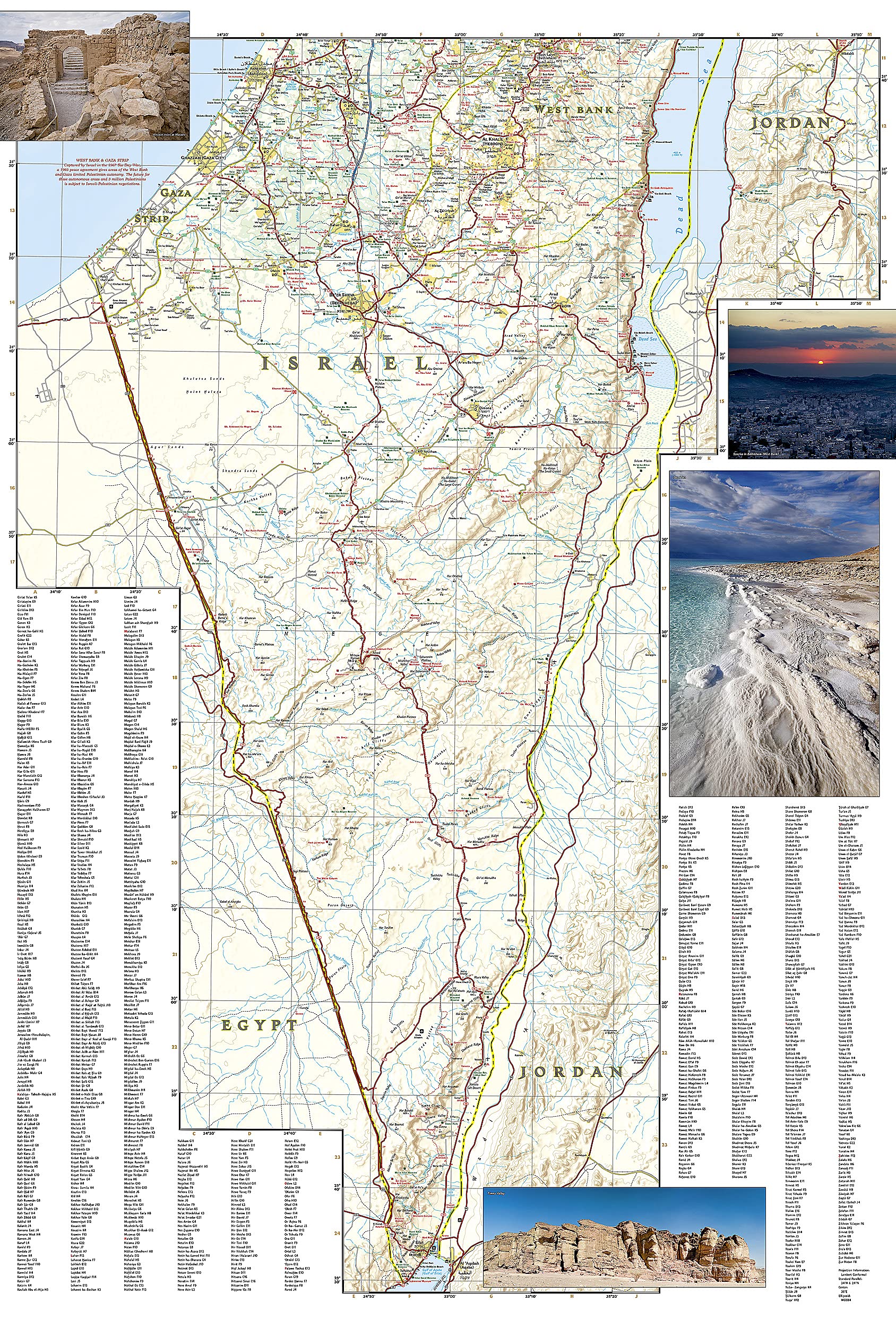
This double-sided map covers the entire modern state of Israel, including all major cities and towns, the West Bank and Gaza Strip, and adjacent areas of Jordan, Syria, Lebanon, and the Sinai Peninsula of Egypt.
🧭 Northern Israel & Surroundings
-
Cities & Regions: Jerusalem, Tel Aviv, Haifa, Acre, Nazareth
-
Natural Features: Sea of Galilee (Kinneret), Mount Carmel, Golan Heights
-
Cultural Sites: Church of the Holy Sepulchre, Western Wall, Dome of the Rock
-
Border Context: Includes West Bank, Jordan Valley, and surrounding borders
🧭 Southern Israel & the Negev Desert
-
Cities & Sites: Be’er Sheva, Hebron, Bethlehem, Eilat, Gaza City
-
Landmarks: Masada, Dead Sea, Ramon Crater, Red Sea coastline
-
Cross-Border Details: Shows Jordanian city of Aqaba and routes into Sinai
📌 Map Features & Highlights
-
✅ Clearly Marked Road Network
Primary & secondary roads with distances, ferry routes, railways, and trails -
✅ Comprehensive City Index
Find any city, town, or site with ease thanks to an intuitive legend and layout -
✅ Cultural & Religious Icons
Synagogues, mosques, churches, sacred sites, and archeological locations -
✅ Natural & Recreational Points of Interest
Hiking trails (including the full Israel National Trail), national parks, beaches, diving areas, hot springs, and birdwatching zones -
✅ Travel Infrastructure
Airports, seaports, border crossings, hostels, hotels, and campsites -
✅ Political Context
Displays boundaries of the West Bank, Gaza Strip, and key regional borders
💪 Built for Adventure
National Geographic’s Adventure Maps are made for the rigors of travel. Each one is:
-
Waterproof – withstands rain, coastal humidity, and spills
-
Tear-resistant – durable enough to be folded and unfolded repeatedly
-
Synthetic Paper – lightweight, recyclable, and environmentally friendly
-
Travel-Sized – folds to 235 x 108 mm for backpacks, gloveboxes, or handbags
📐 Specifications
| Feature | Detail |
|---|---|
| Title | Israel Adventure Map |
| Publisher | National Geographic Maps |
| Edition | Latest available |
| Format | Folded, double-sided map |
| Scale | 1:330,000 |
| Sheet Size | 965 mm x 660 mm |
| Folded Size | 235 mm x 108 mm |
| Material | Waterproof & tear-resistant paper |
| Language | English with key/legend included |
🎯 Ideal For:
-
🕍 Pilgrims & Religious Travelers visiting Israel’s sacred sites
-
🧭 Adventure Tourists trekking desert trails or swimming in the Dead Sea
-
🗺️ Independent Travelers & Overlanders exploring off-the-beaten-track destinations
-
📖 Students & Educators studying the geography, politics, or history of the region
-
🌍 Travel Planners mapping out detailed itineraries across Israel and the West Bank
💬 Why Choose National Geographic Maps?
With over a century of cartographic excellence, National Geographic blends accuracy with insight. These maps aren’t just navigational tools—they’re rich visual companions to help you understand, appreciate, and explore some of the most culturally significant landscapes on Earth.
Frequently Asked Questions
What area does the Israel National Geographic Folded Map cover?
The Israel National Geographic Folded Map provides road coverage of the region named in the product title. The map covers major cities, highways, towns, and regional roads, with inset city maps for key urban centres where applicable.
Is the Israel National Geographic Folded Map up to date?
Yes, this is the current edition. Mapworld stocks the most current editions from all major publishers, updated to reflect new roads and infrastructure.
What size is this map when unfolded?
Folded maps from Mapworld's range are compact and portable. Most standard folded road or travel maps open to between A1 (594 × 841mm) and A0 (841 × 1189mm) when fully unfolded, and fold down to approximately A4 or smaller for easy storage in a glove box, bag, or backpack.
Is the Israel National Geographic Folded Map in stock at Mapworld?
Mapworld maintains extensive stock across its map range and aims for fast dispatch. Orders placed before 2pm AEST on business days are typically dispatched the same day, with standard and express Australia-wide delivery options available.
Does Mapworld ship the Israel National Geographic Folded Map across Australia?
Yes, Mapworld ships Australia-wide. Standard shipping is a flat $7 rate, with free standard shipping on orders over $75. Express options are available at checkout. Most orders placed before 2pm AEST on weekdays are dispatched same day.
Related Items


© 2026 Mapworld. Website designed by Genie Media
X