- Australia ▾
- Topographic
▾
- Australia AUSTopo 250k (2025)
- Australia 50k Geoscience maps
- Australia 100k Geoscience maps
- Australia 250k Geoscience maps
- Australia 1:1m Geoscience maps
- New Zealand 50k maps
- New Zealand 250k maps
- New South Wales 25k maps
- New South Wales 50k maps
- New South Wales 100k maps
- Queensland 10k maps
- Queensland 25k maps
- Queensland 50k maps
- Queensland 100k maps
- Western Australia 25k maps
- Western Australia 50k maps
- Western Australia 100k maps
- Compasses
- Software
- GPS Systems
- International ▾
- Wall Maps
▾
- World
- Australia & New Zealand
- Countries, Continents & Regions
- Historical
- Vintage National Geographic
- Australian Capital Territory
- New South Wales
- Northern Territory
- Queensland
- South Australia
- Tasmania
- Victoria
- Western Australia
- Celestial
- Children's
- Mining & Resources
- Wine Maps
- Healthcare
- Postcode Maps
- Electoral Maps
- Nautical ▾
- Flags
▾
- Australian Flag Sets & Banners
- Flag Bunting
- Handwavers
- Australian National Flags
- Aboriginal Flags
- Torres Strait Islander Flags
- International Flags
- Flagpoles & Accessories
- Australian Capital Territory Flags
- New South Wales Flags
- Northern Territory Flags
- Queensland Flags
- South Australia Flags
- Tasmania Flags
- Victoria Flags
- Western Australia Flags
- Gifts ▾
- Globes ▾
Dear valued customer. Please note that our checkout is not supported by old browsers. Please use a recent browser to access all checkout capabilities


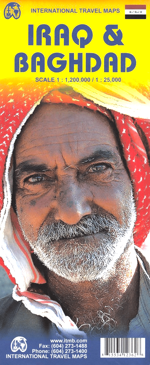
Iraq & Baghdad ITMB Map
$24.95
Afterpay is only available for orders between $50.00 and $1000.00 More info
Double-Sided | Country & City Detail | Updated Edition
Scale: 1:1,200,000 (Iraq) / 1:25,000 (Baghdad) / 1:850,000 (Baghdad Region)
📐 Unfolded Size: 690 mm x 990 mm
🇮🇶 Discover Iraq – Past, Present, and Emerging Future
Despite its complex history and modern challenges, Iraq remains one of the most historically rich regions on Earth — the cradle of Mesopotamia, home of ancient Babylon, Nineveh, and the Tigris-Euphrates heartland. This comprehensive, double-sided map by International Travel Maps (ITMB) is among the most up-to-date available and serves as a vital tool for anyone studying, visiting, or researching this pivotal region.
With a detailed country map on one side and city-focused mapping of Baghdad on the reverse, this edition offers exceptional clarity and information coverage not found in typical tourist maps. Whether you're navigating geography, planning humanitarian logistics, or studying Middle Eastern geopolitics, this is the reference you need.
🌐 Key Features
| 🌟 Feature | 📌 Description |
|---|---|
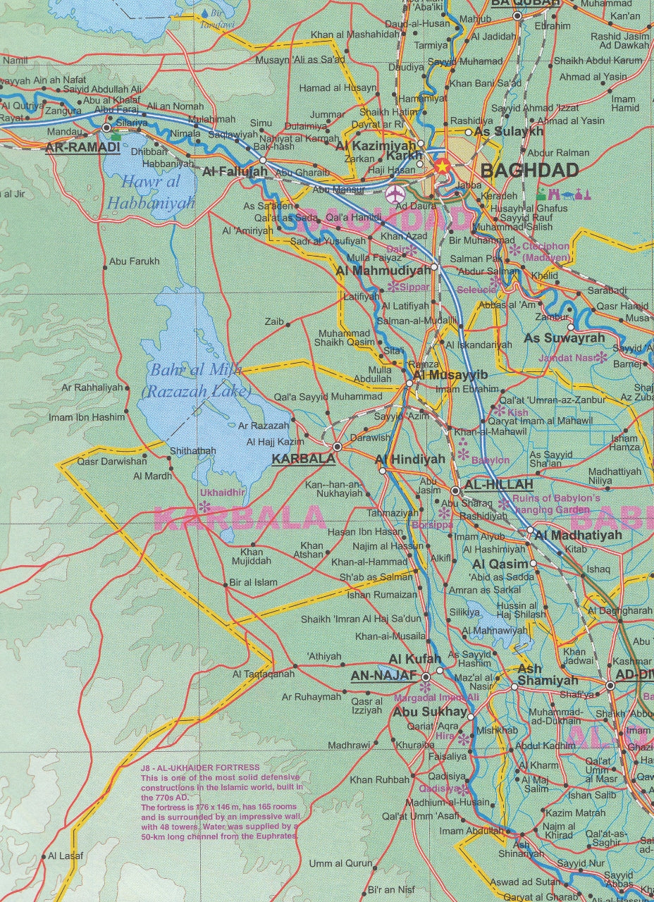
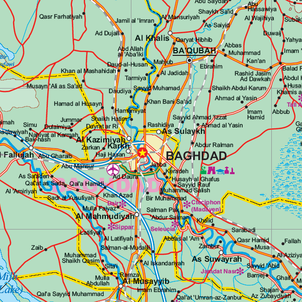
| Full Iraq Country Map | Scale 1:1,200,000 – covers the entire nation including major roads, towns, rivers, terrain features, and border crossings |
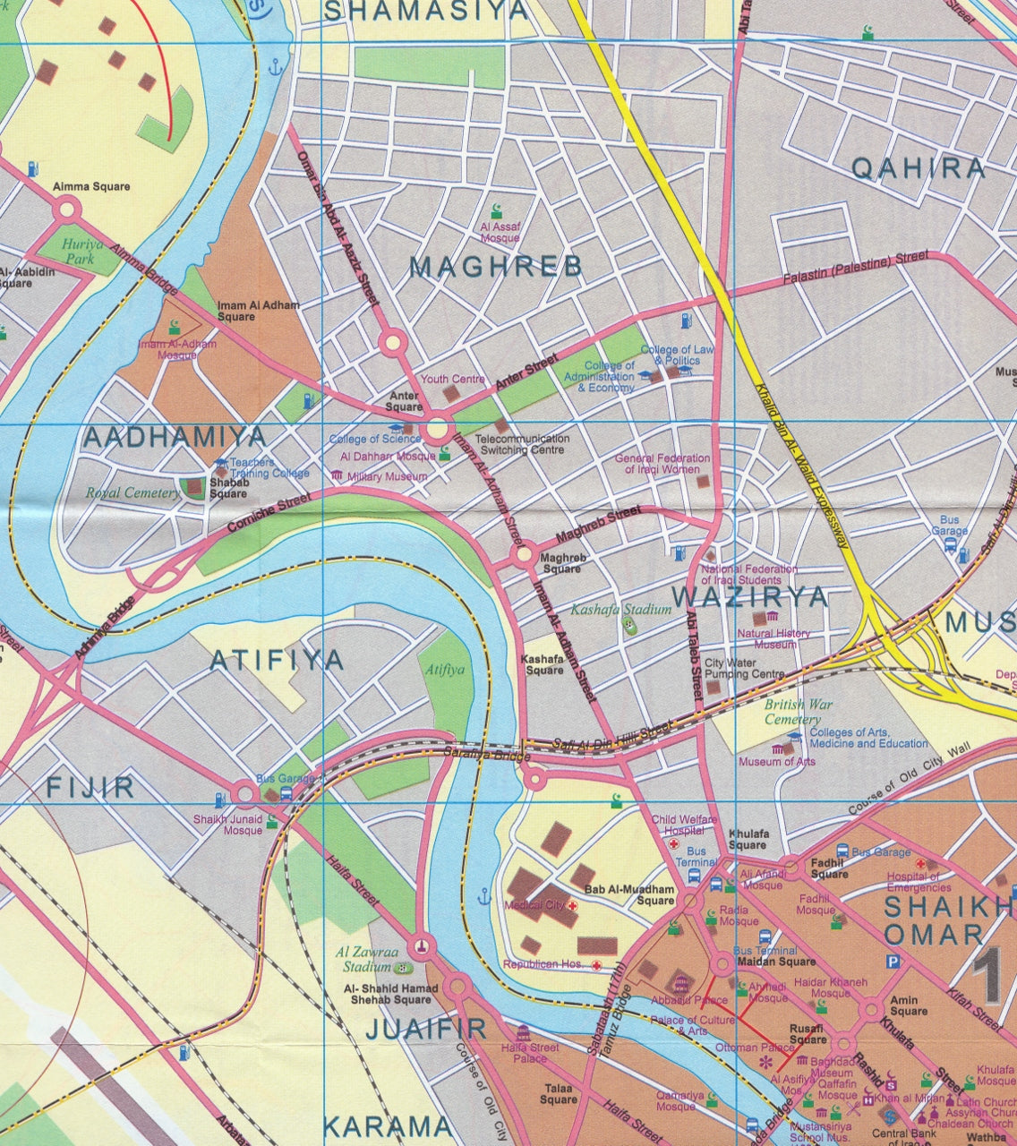
| Baghdad City Map | Scale 1:25,000 – street-level detail of Iraq’s capital with key government buildings, markets, transport hubs, and historic sites |
| Baghdad Regional Map | Scale 1:850,000 – shows greater Baghdad area, ideal for planning access or movement around the central zone |
| Place Name Index | Extensive gazetteer for both city and country maps to make navigation easy |
| Political & Physical Detail | Major roadways, rivers, airports, pipelines, and administrative boundaries clearly shown |
| Double-Sided Format | Efficient layout maximizes readability and geographic scope without bulk |
| Modern Cartography | Clean, legible design with shaded relief and Arabic-English place names where possible |
📐 Map Specifications
| Specification | Detail |
|---|---|
| Map Type | Folded, double-sided |
| Publisher | ITMB (International Travel Maps) |
| Country Scale | 1:1,200,000 |
| City Scale | 1:25,000 (Baghdad) |
| Regional Scale | 1:850,000 (Baghdad Surrounds) |
| Unfolded Size | 690 mm x 990 mm |
| Folded Size | Compact and portable |
🧭 Optional Lamination
Upgrade your map with professional lamination for:
-
✅ Durability – Waterproof, tear-resistant, and perfect for field use
-
✅ Interactivity – Use whiteboard markers to plot locations or routes
-
✅ Protection – Safeguards your map from wear, stains, and weather
🔧 Note: Laminated maps are carefully flattened and encapsulated in two layers of 80-micron gloss laminate. Minor fold lines may remain visible due to the original fold format.
👤 Who Is This Map For?
This highly functional map is ideal for:
-
🌍 Travelers, journalists, or researchers working in or studying Iraq
-
🎓 Educators, students, and academics seeking accurate cartographic resources
-
🏛️ Historians and archaeologists tracing ancient Mesopotamian routes
-
🧳 Aid workers, NGOs, and logistic planners operating in-country
-
📚 Map collectors and Middle East specialists
🏙️ Notable Locations Shown
-
Baghdad – The capital city with detailed street layout, government precincts, and historical landmarks
-
Basra, Mosul, Erbil, Kirkuk – Major urban and economic hubs across the country
-
Euphrates and Tigris Rivers – Lifelines of ancient civilization clearly marked
-
Ancient sites – Babylon, Ur, Nineveh, and other archaeological points of interest
-
Border zones – Clearly defined international borders with Iran, Turkey, Syria, Jordan, Saudi Arabia, and Kuwait
🛒 Why Choose This Map?
✔️ One of the most current and detailed Iraq maps available
✔️ Unique combination of country and capital coverage
✔️ Printed on paper with optional lamination for long-term use
✔️ A powerful reference for travel, research, education, or logistics
Explore Iraq with confidence and clarity. From Baghdad’s bustling streets to the timeless rivers of ancient Mesopotamia, the Iraq & Baghdad ITMB map is an essential guide to one of the world's most historically significant regions.
Frequently Asked Questions
Where can I buy the Iraq & Baghdad ITMB Map?
The Iraq & Baghdad ITMB Map is available to buy online from Mapworld, Australia's largest map and geographic product retailer, with fast shipping Australia-wide.
Is the Iraq & Baghdad ITMB Map in stock at Mapworld?
Mapworld maintains extensive stock across its map range and aims for fast dispatch. Orders placed before 2pm AEST on business days are typically dispatched the same day, with standard and express Australia-wide delivery options available.
What is Mapworld's returns policy?
Mapworld accepts returns on undamaged items in original condition. Contact Mapworld within 90 days of purchase to arrange a return or exchange.
Does Mapworld ship the Iraq & Baghdad ITMB Map across Australia?
Yes, Mapworld ships Australia-wide. Standard shipping is a flat $7 rate, with free standard shipping on orders over $75. Express options are available at checkout. Most orders placed before 2pm AEST on weekdays are dispatched same day.
Related Items


© 2026 Mapworld. Website designed by Genie Media
X