- Australia ▾
- Topographic
▾
- Australia AUSTopo 250k (2025)
- Australia 50k Geoscience maps
- Australia 100k Geoscience maps
- Australia 250k Geoscience maps
- Australia 1:1m Geoscience maps
- New Zealand 50k maps
- New Zealand 250k maps
- New South Wales 25k maps
- New South Wales 50k maps
- New South Wales 100k maps
- Queensland 10k maps
- Queensland 25k maps
- Queensland 50k maps
- Queensland 100k maps
- Western Australia 25k maps
- Western Australia 50k maps
- Western Australia 100k maps
- Compasses
- Software
- GPS Systems
- International ▾
- Wall Maps
▾
- World
- Australia & New Zealand
- Countries, Continents & Regions
- Historical
- Vintage National Geographic
- Australian Capital Territory
- New South Wales
- Northern Territory
- Queensland
- South Australia
- Tasmania
- Victoria
- Western Australia
- Celestial
- Children's
- Mining & Resources
- Wine Maps
- Healthcare
- Postcode Maps
- Electoral Maps
- Nautical ▾
- Flags
▾
- Australian Flag Sets & Banners
- Flag Bunting
- Handwavers
- Australian National Flags
- Aboriginal Flags
- Torres Strait Islander Flags
- International Flags
- Flagpoles & Accessories
- Australian Capital Territory Flags
- New South Wales Flags
- Northern Territory Flags
- Queensland Flags
- South Australia Flags
- Tasmania Flags
- Victoria Flags
- Western Australia Flags
- Gifts ▾
- Globes ▾
Dear valued customer. Please note that our checkout is not supported by old browsers. Please use a recent browser to access all checkout capabilities


Midlands & Central England AA Road Map 5
$19.95
Afterpay is only available for orders between $50.00 and $1000.00 More info
Scale: 1:200,000 (3 miles to 1 inch / 2km to 1cm)
Format: Folded paper map
Size (unfolded): 1200 mm x 980 mm
Publisher: AA (Automobile Association)
Edition: 2024 – Fully Updated
🗺️ Your Essential Road Companion Through England’s Heartland
Whether you're exploring the idyllic lanes of the Cotswolds, navigating business routes through the West Midlands, or road-tripping across central England, the AA Midlands & Central England Road Map is your indispensable guide.
Produced by the trusted Automobile Association, this clear and easy-to-read regional map combines road network precision with valuable travel information—ideal for holidaymakers, day-trippers, and professional drivers alike.
🧭 Key Features at a Glance
✔️ Fully updated 2024 edition with the latest road changes
✔️ Speed camera locations shown, including those with speed limits
✔️ 8 detailed city centre plans for urban navigation:
-
Birmingham
-
Derby
-
Leicester
-
Cheltenham
-
Coventry
-
Milton Keynes
-
Nottingham
-
Wolverhampton
✔️ National Parks & scenic highlights clearly marked
✔️ Toll roads, service areas, and road classifications for route planning
✔️ Caravan & camping sites pinpointed for touring convenience
✔️ National Trust, English Heritage, Welsh & Scottish Heritage sites displayed
✔️ Clear place name index to quickly locate towns, villages, and landmarks
✔️ Encased in a weather-resistant cover for travel durability
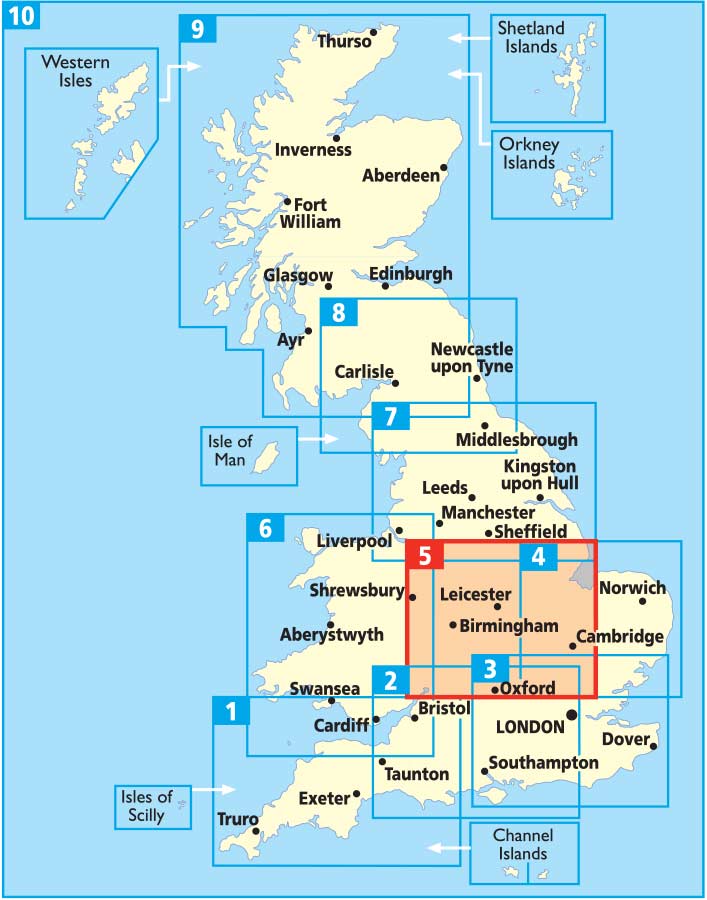
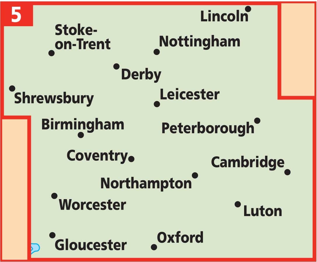
🗺️ Coverage Area
This map covers a wide central band of England, including:
-
The Cotswolds Area of Outstanding Natural Beauty
-
Key urban centres: Birmingham, Coventry, Nottingham, and Leicester
-
The Peak District’s southern edge
-
Stratford-upon-Avon, Warwick, and Oxfordshire fringe
-
Parts of Shropshire, Staffordshire, and Northamptonshire
Whether you’re chasing heritage sites, country pubs, stately homes, or rural walking routes—this map keeps you confidently on course.
📐 Product Specifications
| Feature | Details |
|---|---|
| Scale | 1:200,000 (3 miles to 1 inch) |
| Unfolded Size | 1200 mm x 980 mm |
| Format | Folded paper map |
| Map Type | Road & Touring Map |
| City Plans Included | 8 major urban centres |
| Speed Cameras | Yes, with speed limits |
| Campgrounds Shown | Yes |
| Heritage Sites | NT, EH, WHS, SHS indicated |
| Publisher | AA (UK) |
| Publication Year | 2024 |
🎯 Who Is This Map For?
🧳 Leisure travellers & holidaymakers looking to explore Central England by car
🚐 Touring caravan & camping enthusiasts
🚗 Professional drivers, couriers, and logistics planners
📚 Students, educators & researchers needing regional detail
🎁 Gift buyers seeking a practical and informative present for UK road trippers
🚚 Delivery Note
This is a stocked product. Ships within 1–3 business days.
Discover the road less travelled—or the quickest route to your next meeting—with the Midlands & Central England AA Road Map 5. Packed with detail, built to last, and designed for real journeys across the heart of England.
Frequently Asked Questions
What area does the Midlands & Central England AA Road Map 5 cover?
The Midlands & Central England AA Road Map 5 provides road coverage of the region named in the product title. The map covers major cities, highways, towns, and regional roads, with inset city maps for key urban centres where applicable.
Is the Midlands & Central England AA Road Map 5 up to date?
Yes, this is the current edition. Mapworld stocks the most current editions from all major publishers, updated to reflect new roads and infrastructure.
What size is this map when unfolded?
Folded maps from Mapworld's range are compact and portable. Most standard folded road or travel maps open to between A1 (594 × 841mm) and A0 (841 × 1189mm) when fully unfolded, and fold down to approximately A4 or smaller for easy storage in a glove box, bag, or backpack.
Is the Midlands & Central England AA Road Map 5 in stock at Mapworld?
Mapworld maintains extensive stock across its map range and aims for fast dispatch. Orders placed before 2pm AEST on business days are typically dispatched the same day, with standard and express Australia-wide delivery options available.
Does Mapworld ship the Midlands & Central England AA Road Map 5 across Australia?
Yes, Mapworld ships Australia-wide. Standard shipping is a flat $7 rate, with free standard shipping on orders over $75. Express options are available at checkout. Most orders placed before 2pm AEST on weekdays are dispatched same day.
Related Items


© 2026 Mapworld. Website designed by Genie Media
X