- Australia ▾
- Topographic
▾
- Australia AUSTopo 250k (2025)
- Australia 50k Geoscience maps
- Australia 100k Geoscience maps
- Australia 250k Geoscience maps
- Australia 1:1m Geoscience maps
- New Zealand 50k maps
- New Zealand 250k maps
- New South Wales 25k maps
- New South Wales 50k maps
- New South Wales 100k maps
- Queensland 10k maps
- Queensland 25k maps
- Queensland 50k maps
- Queensland 100k maps
- Western Australia 25k maps
- Western Australia 50k maps
- Western Australia 100k maps
- Compasses
- Software
- GPS Systems
- International ▾
- Wall Maps
▾
- World
- Australia & New Zealand
- Countries, Continents & Regions
- Historical
- Vintage National Geographic
- Australian Capital Territory
- New South Wales
- Northern Territory
- Queensland
- South Australia
- Tasmania
- Victoria
- Western Australia
- Celestial
- Children's
- Mining & Resources
- Wine Maps
- Healthcare
- Postcode Maps
- Electoral Maps
- Nautical ▾
- Flags
▾
- Australian Flag Sets & Banners
- Flag Bunting
- Handwavers
- Australian National Flags
- Aboriginal Flags
- Torres Strait Islander Flags
- International Flags
- Flagpoles & Accessories
- Australian Capital Territory Flags
- New South Wales Flags
- Northern Territory Flags
- Queensland Flags
- South Australia Flags
- Tasmania Flags
- Victoria Flags
- Western Australia Flags
- Gifts ▾
- Globes ▾
Dear valued customer. Please note that our checkout is not supported by old browsers. Please use a recent browser to access all checkout capabilities


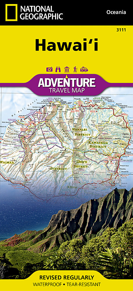
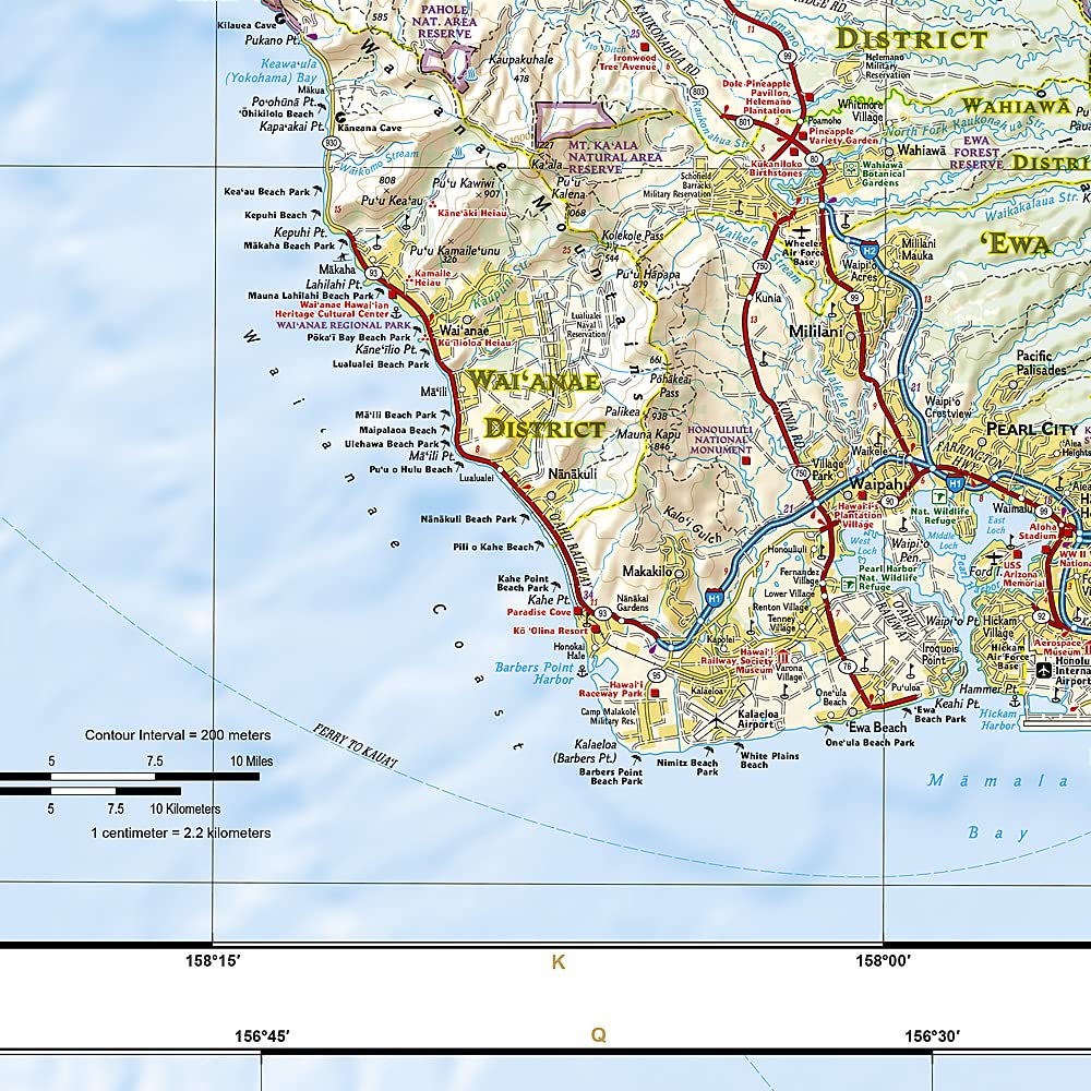
Hawaii National Geographic Folded Map
$27.95
Afterpay is only available for orders between $50.00 and $1000.00 More info
🏝️ Hawaii Adventure Travel Map – National Geographic
Folded Waterproof Map • All 8 Main Islands • Durable • Adventure-Ready
Discover the magic of the Hawaiian Islands with National Geographic’s Hawaii Adventure Map — a beautifully rendered and highly functional travel companion designed for explorers who want to go beyond the resorts and into the heart of nature, culture, and history.
This map covers all eight main Hawaiian Islands in their entirety and provides accurate, up-to-date cartographic detail, whether you're planning a road trip, a volcano hike, or an off-the-grid island escape.
🗺️ Features & Coverage
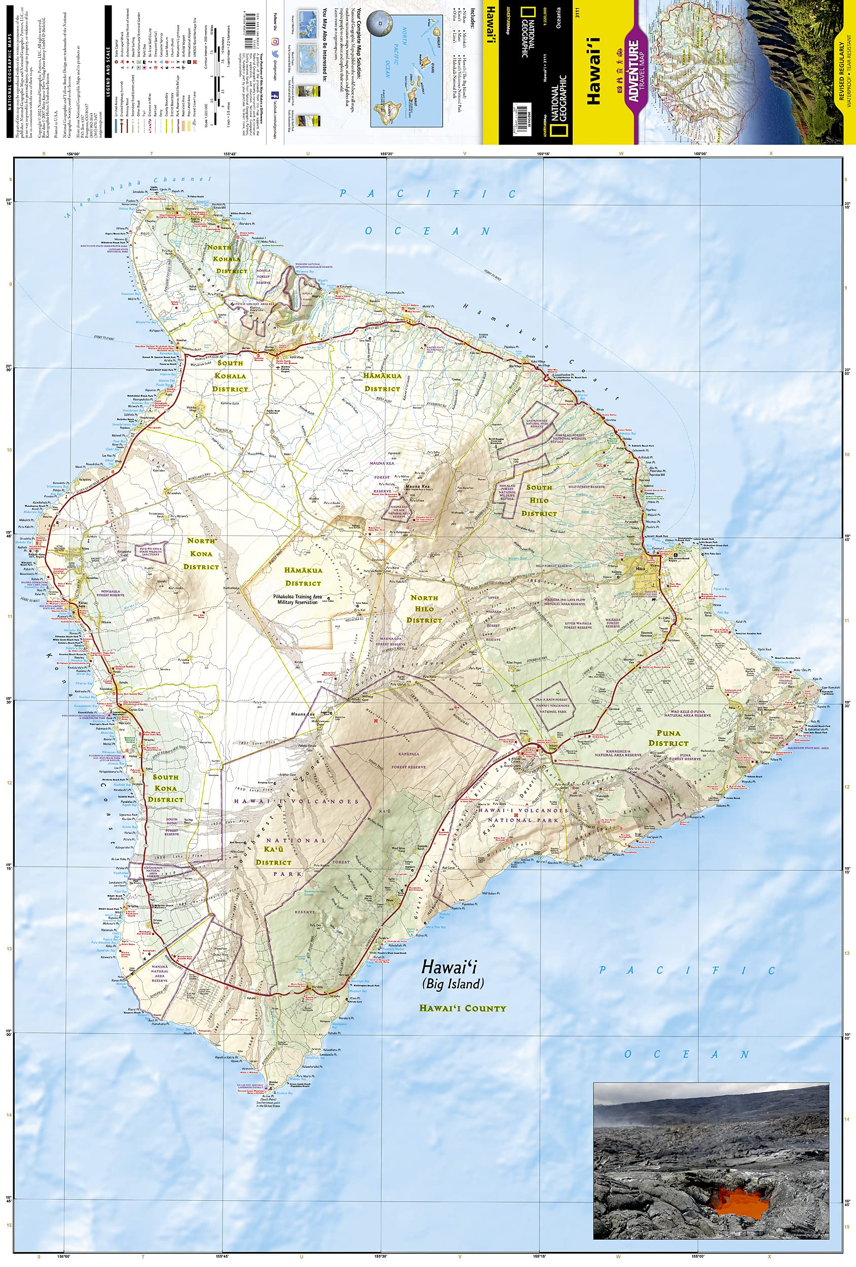
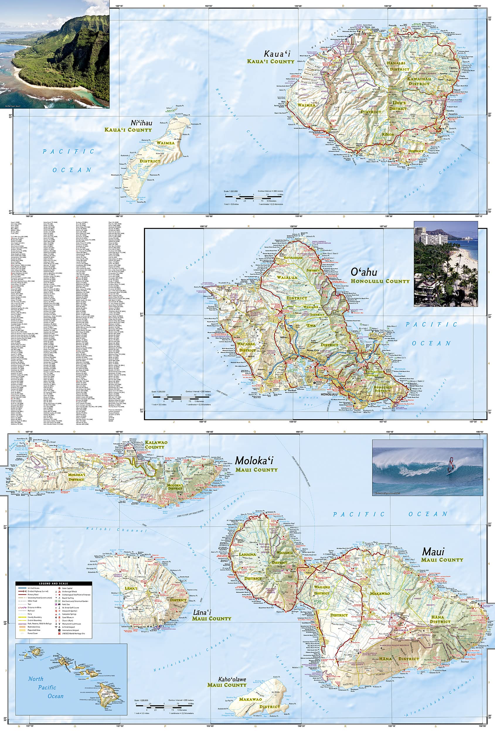
Covering the entire archipelago, this folded, double-sided map includes:
-
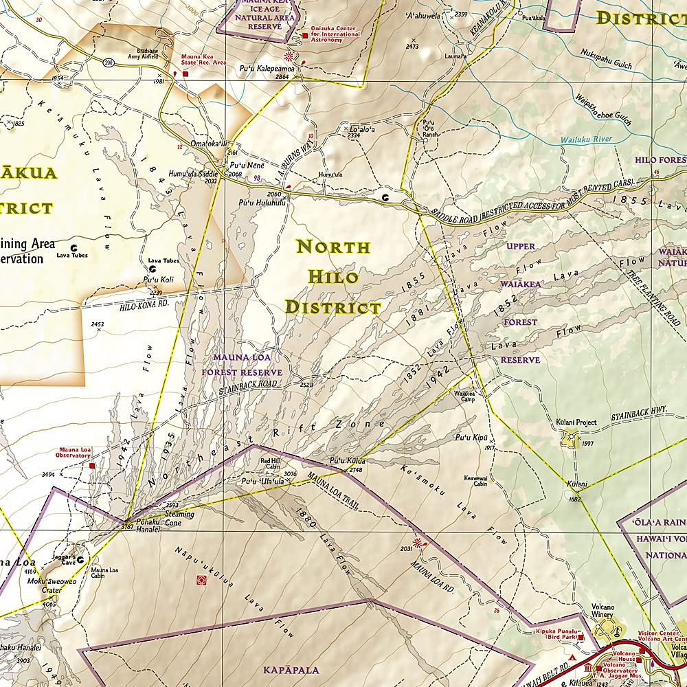
The Big Island (Hawai‘i) – with detailed highlights of Hawai‘i Volcanoes National Park, Mauna Kea, and Pu‘uhonua o Hōnaunau
-
Maui – including Haleakalā National Park and the Road to Hāna
-
O‘ahu – showing Honolulu, Waikīkī, Pearl Harbor, Hanauma Bay, and more
-
Kaua‘i – with Waimea Canyon and the Nā Pali Coast
-
Moloka‘i, Lāna‘i, Kaho‘olawe, and Ni‘ihau – lesser-visited islands with unique heritage and scenery
🌋 Adventure Highlights & Points of Interest
This isn’t just a road map—it’s your gateway to adventure:
-
🧭 National Parks & Monuments: Haleakalā, Hawai‘i Volcanoes, USS Arizona Memorial, Kalaupapa
-
🥾 Recreational Sites: Hiking trails, campsites, scenic viewpoints
-
🏄🏽 Outdoor Activities: Surf spots, snorkeling areas, diving zones, golf courses
-
🐢 Natural Attractions: Waterfalls, springs, caves, beaches, and protected nature reserves
-
🏛️ Cultural & Historic Sites: Archaeological zones, temples, sacred sites
-
🦜 Wildlife Refuges & Conservation Areas: Clearly marked boundaries of protected regions
📌 Practical Travel Tools
| Feature | Description |
|---|---|
| Scale | 1:220,000 |
| Map Type | Double-sided folded map |
| Sheet Size | 959 x 648 mm |
| Index Included | Yes – full city/town index |
| Road Details | Highways, secondary roads, inter-island ferry routes, mile markers |
| Waterproof & Tear-resistant | Yes – printed on durable synthetic paper |
✅ Why Choose This Map?
-
🌺 Comprehensive island coverage from Kaua‘i to Hawai‘i (Big Island)
-
📍 Detailed and adventure-ready – includes both famous sites and hidden gems
-
💧 Waterproof and tear-resistant – perfect for tropical climates and rugged conditions
-
🧭 Perfect planning tool to pair with a Hawaii travel guide
-
🎒 Lightweight and packable – folds down to fit in your backpack or glovebox
🌴 Ideal For:
-
✈️ International visitors planning a multi-island trip
-
🧭 Independent travelers, hikers, and adventurers
-
🚙 Road trippers, van lifers, and camping enthusiasts
-
📚 Teachers and students of geography and natural sciences
-
🎁 A unique and practical gift for anyone dreaming of Hawaii
National Geographic’s Hawaii Adventure Map is more than just a map — it’s an invitation to explore one of the world’s most enchanting island chains in vivid detail.
Frequently Asked Questions
What area does the Hawaii National Geographic Folded Map cover?
The Hawaii National Geographic Folded Map provides road coverage of the region named in the product title. The map covers major cities, highways, towns, and regional roads, with inset city maps for key urban centres where applicable.
Is the Hawaii National Geographic Folded Map up to date?
Yes, this is the current edition. Mapworld stocks the most current editions from all major publishers, updated to reflect new roads and infrastructure.
What size is this map when unfolded?
Folded maps from Mapworld's range are compact and portable. Most standard folded road or travel maps open to between A1 (594 × 841mm) and A0 (841 × 1189mm) when fully unfolded, and fold down to approximately A4 or smaller for easy storage in a glove box, bag, or backpack.
Is the Hawaii National Geographic Folded Map in stock at Mapworld?
Mapworld maintains extensive stock across its map range and aims for fast dispatch. Orders placed before 2pm AEST on business days are typically dispatched the same day, with standard and express Australia-wide delivery options available.
Does Mapworld ship the Hawaii National Geographic Folded Map across Australia?
Yes, Mapworld ships Australia-wide. Standard shipping is a flat $7 rate, with free standard shipping on orders over $75. Express options are available at checkout. Most orders placed before 2pm AEST on weekdays are dispatched same day.
Related Items


© 2026 Mapworld. Website designed by Genie Media
X