- Australia ▾
- Topographic
▾
- Australia AUSTopo 250k (2025)
- Australia 50k Geoscience maps
- Australia 100k Geoscience maps
- Australia 250k Geoscience maps
- Australia 1:1m Geoscience maps
- New Zealand 50k maps
- New Zealand 250k maps
- New South Wales 25k maps
- New South Wales 50k maps
- New South Wales 100k maps
- Queensland 10k maps
- Queensland 25k maps
- Queensland 50k maps
- Queensland 100k maps
- Western Australia 25k maps
- Western Australia 50k maps
- Western Australia 100k maps
- Compasses
- Software
- GPS Systems
- International ▾
- Wall Maps
▾
- World
- Australia & New Zealand
- Countries, Continents & Regions
- Historical
- Vintage National Geographic
- Australian Capital Territory
- New South Wales
- Northern Territory
- Queensland
- South Australia
- Tasmania
- Victoria
- Western Australia
- Celestial
- Children's
- Mining & Resources
- Wine Maps
- Healthcare
- Postcode Maps
- Electoral Maps
- Nautical ▾
- Flags
▾
- Australian Flag Sets & Banners
- Flag Bunting
- Handwavers
- Australian National Flags
- Aboriginal Flags
- Torres Strait Islander Flags
- International Flags
- Flagpoles & Accessories
- Australian Capital Territory Flags
- New South Wales Flags
- Northern Territory Flags
- Queensland Flags
- South Australia Flags
- Tasmania Flags
- Victoria Flags
- Western Australia Flags
- Gifts ▾
- Globes ▾
Dear valued customer. Please note that our checkout is not supported by old browsers. Please use a recent browser to access all checkout capabilities


Ethiopia & Eritrea ITMB Map
$24.95
Afterpay is only available for orders between $50.00 and $1000.00 More info
🌍 Ethiopia & Eritrea Travel Map – ITMB
Double-Sided | Topographic Relief | Optional Lamination
Scale: 1:1,900,000 (Ethiopia) / 1:900,000 (Eritrea)
Flat Size: 680 mm x 990 mm (26.8" x 39")
Format: Folded map (laminated option available)
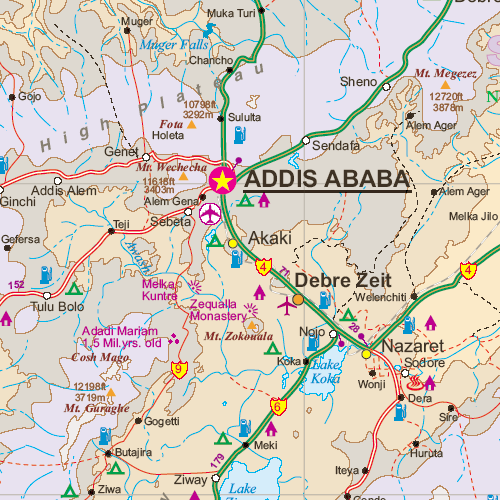
Explore the rugged highlands and historical heartlands of Northeast Africa with this double-sided map of Ethiopia and Eritrea by International Travel Maps (ITMB). Carefully researched and clearly rendered, this map provides a valuable combination of topographical context, modern road networks, and key cultural highlights across two countries steeped in history and natural beauty.
Whether you're planning an overland journey, tracing ancient trade routes, or teaching about the region's complex geography, this map delivers a detailed and practical view of two interconnected yet distinct nations.
🗺️ Map Coverage
🇪🇹 Side 1: Ethiopia (Scale 1:1,900,000)
-
Covers the entire country, from the Danakil Depression in the east to the western borderlands near Sudan
-
Key features:
-
🏙️ Capital city Addis Ababa with detailed inset map
-
🛣️ Main road connections to Dire Dawa, Harar, Gondar, Axum, and Bahir Dar
-
🏞️ Topographic shading showing mountainous central highlands and lowland deserts
-
🚧 Border crossings marked (note: some may be politically restricted)
-
📍 List of Top Attractions to assist visitors
-
🇪🇷 Side 2: Eritrea (Scale 1:900,000)
-
Shows Eritrea in full, from the Red Sea coast to the western plateaus
-
Features include:
-
🏙️ Capital city Asmara, with a detailed city inset map
-
🌍 Coastal cities such as Massawa and Assab
-
📍 Historical and cultural landmarks
-
🗺️ Inset map of Djibouti, including the capital and key infrastructure
-
🧭 Terrain shading to highlight mountains and valleys
-
🧾 Top Attractions list tailored for travellers
-
🌟 Key Features
-
📄 Double-sided sheet with individual country coverage
-
🗺️ Topographical relief shading gives a sense of terrain
-
🛣️ Roads, highways, and regional connectors marked with distances
-
🧭 Latitude/longitude grid for GPS reference
-
🧾 Major towns, cities, and points of interest clearly labelled
-
🏛️ Inset maps for:
-
Addis Ababa (Ethiopia)
-
Asmara (Eritrea)
-
Djibouti (country and city)
-
💧 Lamination Option Available
Make your map adventure-ready with our optional lamination service:
-
✔️ Write on it with whiteboard markers or add map dots
-
✔️ Enhanced durability and stain resistance
-
✔️ Ideal for fieldwork, travel planning, or classroom use
📌 Note: Laminated versions are produced by flattening and encapsulating the folded map. Some faint fold lines may still be visible.
🧾 Map Specifications
| Feature | Details |
|---|---|
| Publisher | ITMB (International Travel Maps) |
| Edition | Latest available |
| Map Type | Folded, double-sided |
| Material | Paper (laminated version optional) |
| Flat Size | 680 mm x 990 mm (26.8" x 39") |
| Language | English |
🧳 Who Is This Map For?
Perfect for:
-
✈️ Adventurous travellers exploring the Horn of Africa
-
🗺️ Educators and students studying East African geography and geopolitics
-
🧭 Expedition planners and NGOs operating in the region
-
📚 Historians and archaeologists interested in Axumite and Red Sea heritage
-
🧑💼 Tour operators offering cultural or nature-based itineraries
🌍 Why Choose This Map?
This is one of the few detailed, travel-ready maps available for the region, combining historical richness, challenging terrain, and modern infrastructure in one comprehensive sheet. Whether you're planning a journey through the Simien Mountains, exploring Asmara’s Italian colonial architecture, or seeking context for the Horn of Africa’s complex borders, this map offers essential guidance.
Frequently Asked Questions
Where can I buy the Ethiopia & Eritrea ITMB Map?
The Ethiopia & Eritrea ITMB Map is available to buy online from Mapworld, Australia's largest map and geographic product retailer, with fast shipping Australia-wide.
Is the Ethiopia & Eritrea ITMB Map in stock at Mapworld?
Mapworld maintains extensive stock across its map range and aims for fast dispatch. Orders placed before 2pm AEST on business days are typically dispatched the same day, with standard and express Australia-wide delivery options available.
What is Mapworld's returns policy?
Mapworld accepts returns on undamaged items in original condition. Contact Mapworld within 90 days of purchase to arrange a return or exchange.
Does Mapworld ship the Ethiopia & Eritrea ITMB Map across Australia?
Yes, Mapworld ships Australia-wide. Standard shipping is a flat $7 rate, with free standard shipping on orders over $75. Express options are available at checkout. Most orders placed before 2pm AEST on weekdays are dispatched same day.
Related Items


© 2026 Mapworld. Website designed by Genie Media
X