- Australia ▾
- Topographic
▾
- Australia AUSTopo 250k (2025)
- Australia 50k Geoscience maps
- Australia 100k Geoscience maps
- Australia 250k Geoscience maps
- Australia 1:1m Geoscience maps
- New Zealand 50k maps
- New Zealand 250k maps
- New South Wales 25k maps
- New South Wales 50k maps
- New South Wales 100k maps
- Queensland 10k maps
- Queensland 25k maps
- Queensland 50k maps
- Queensland 100k maps
- Western Australia 25k maps
- Western Australia 50k maps
- Western Australia 100k maps
- Compasses
- Software
- GPS Systems
- International ▾
- Wall Maps
▾
- World
- Australia & New Zealand
- Countries, Continents & Regions
- Historical
- Vintage National Geographic
- Australian Capital Territory
- New South Wales
- Northern Territory
- Queensland
- South Australia
- Tasmania
- Victoria
- Western Australia
- Celestial
- Children's
- Mining & Resources
- Wine Maps
- Healthcare
- Postcode Maps
- Electoral Maps
- Nautical ▾
- Flags
▾
- Australian Flag Sets & Banners
- Flag Bunting
- Handwavers
- Australian National Flags
- Aboriginal Flags
- Torres Strait Islander Flags
- International Flags
- Flagpoles & Accessories
- Australian Capital Territory Flags
- New South Wales Flags
- Northern Territory Flags
- Queensland Flags
- South Australia Flags
- Tasmania Flags
- Victoria Flags
- Western Australia Flags
- Gifts ▾
- Globes ▾
Dear valued customer. Please note that our checkout is not supported by old browsers. Please use a recent browser to access all checkout capabilities


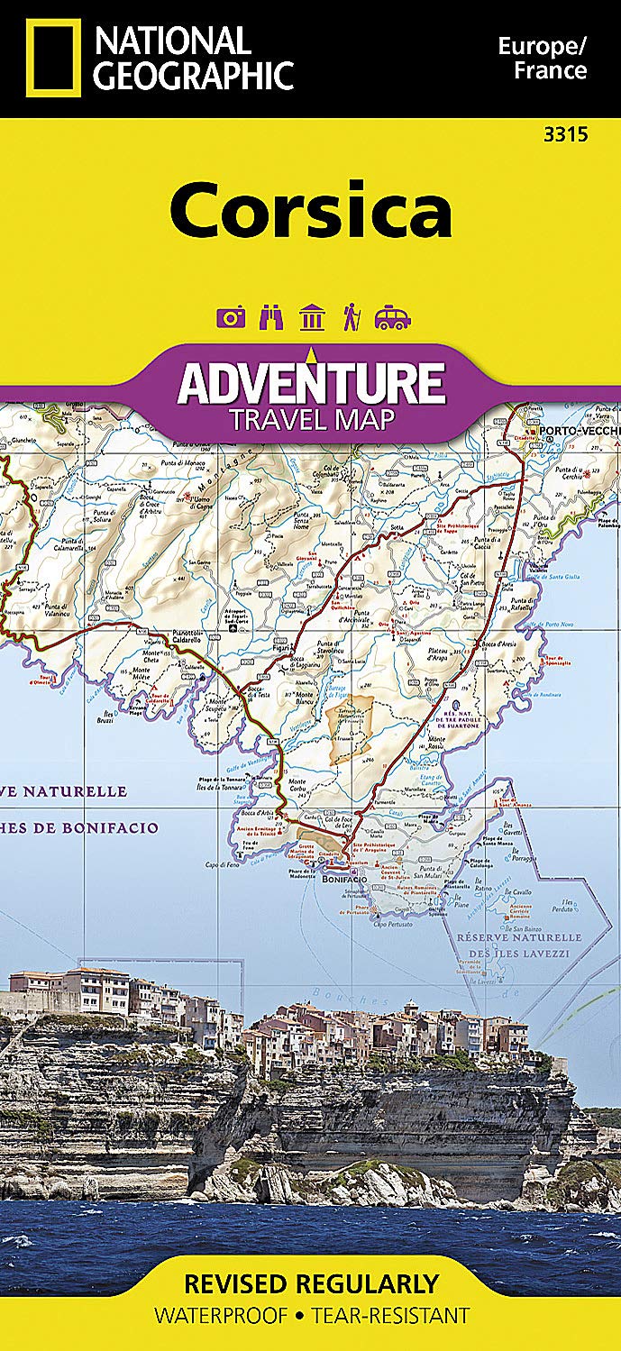
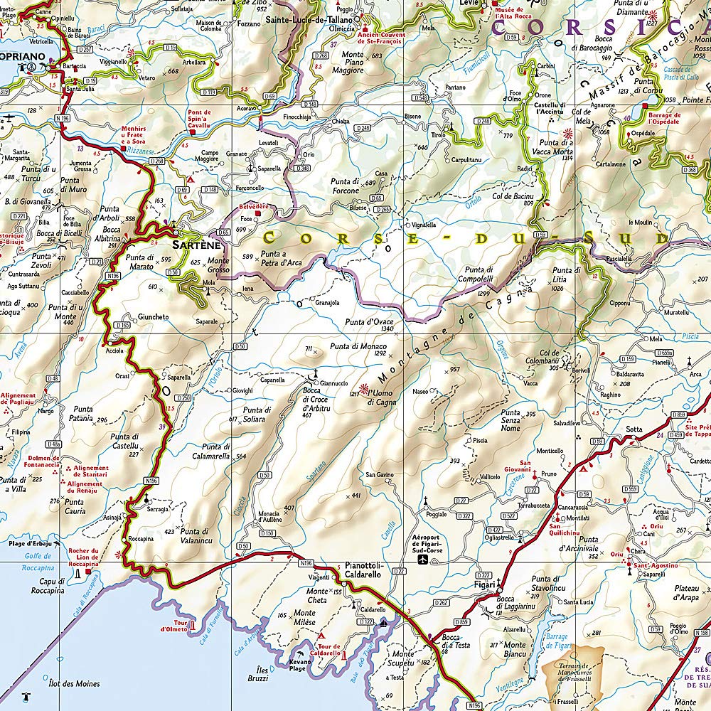
Corsica National Geographic Folded Map
$27.95
Afterpay is only available for orders between $50.00 and $1000.00 More info
Waterproof • Tear-Resistant • Folded Map
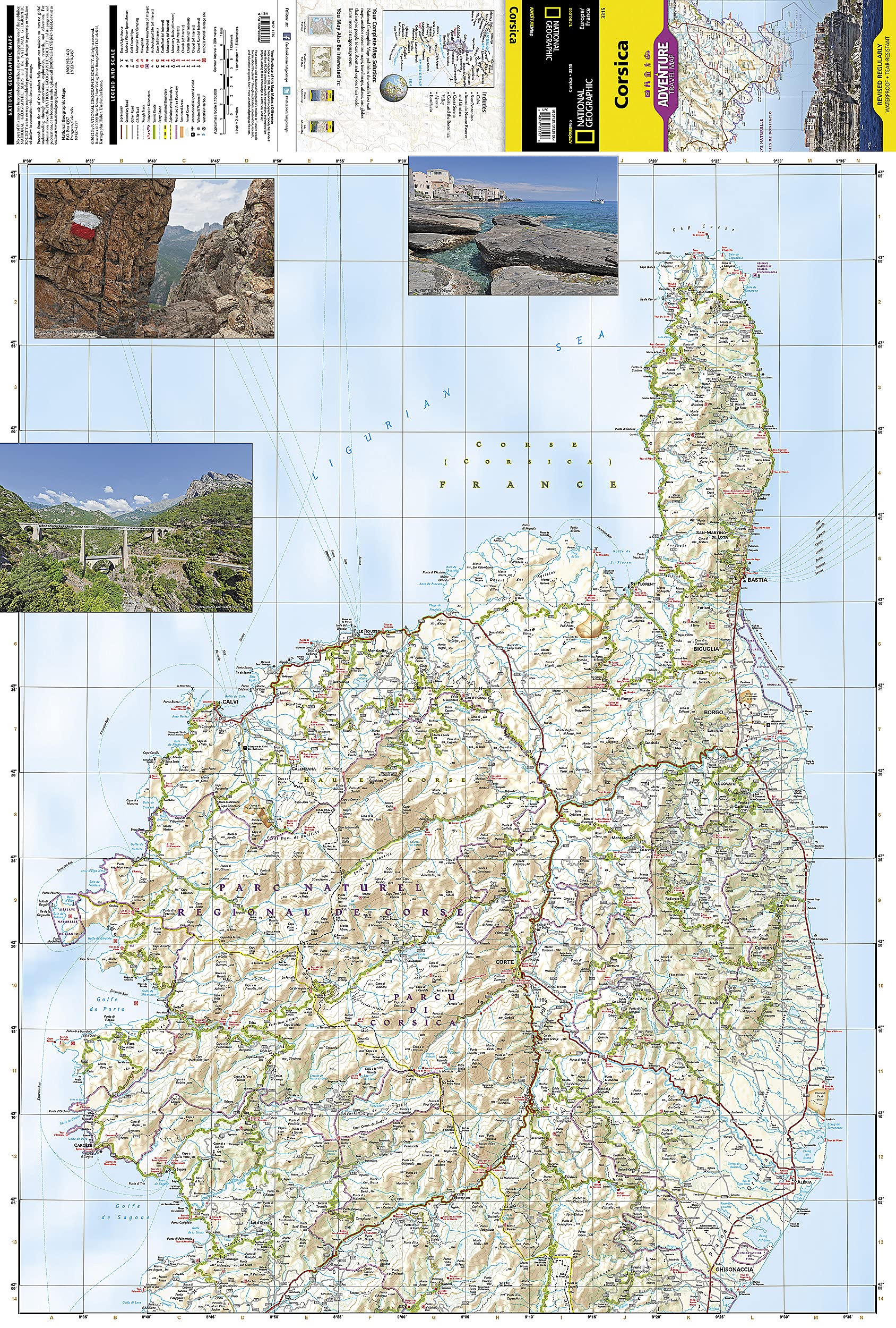
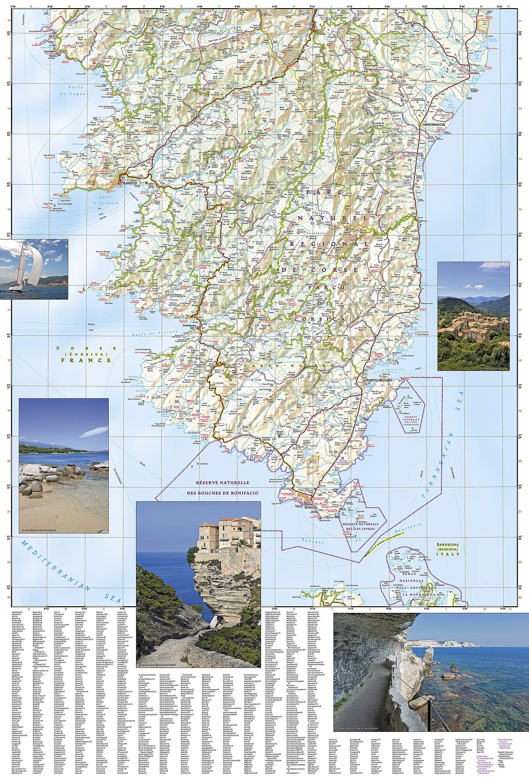
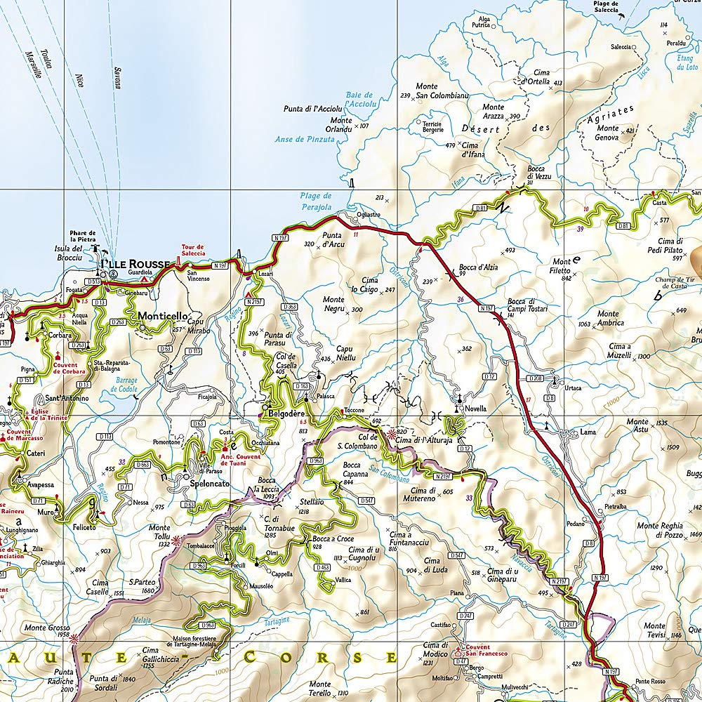
Scale: 1:150,000 | Unfolded Size: 965 mm × 660 mm | Folded: 235 mm × 108 mm
🇫🇷 Discover the Untamed Beauty of Corsica
Explore the dramatic coastline, mountainous interior, and timeless villages of Corsica with National Geographic’s Adventure Map, expertly crafted for travellers who demand both durability and detailed accuracy. Whether you’re hiking the GR20 trail, driving along rugged coastal roads, or uncovering historic towns like Calvi, Ajaccio, and Bonifacio, this waterproof map is your essential travel companion.
🧭 Key Features:
-
Waterproof & Tear-Resistant
-
Printed on tough synthetic paper designed to endure outdoor use, folding and unfolding, and rough travel conditions.
-
-
Clear & Accurate Cartography
-
Major highways, secondary roads, and scenic routes
-
Tracks and trails for walkers and cyclists
-
Distances clearly marked between points
-
-
Topographic & Natural Detail
-
Elevation contours and shaded relief for a clear sense of terrain
-
Coastal features, rivers, gorges, and peaks marked
-
Locations of national parks, reserves, and protected areas
-
-
Tourist & Cultural Highlights
-
Towns, villages, archaeological sites, castles, and heritage points
-
Beaches, ports, ferry routes, and viewpoints
-
Detailed index of place names for easy navigation
-
-
Two-Sided Coverage
-
Side One: Northern Corsica — including the Cap Corse Peninsula, St.-Florent, Calvi, and Bastia
-
Side Two: Southern Corsica — including Ajaccio, Bonifacio, Porto-Vecchio, and the southern mountain ranges
-
Clearly labeled gulfs, seas, and maritime boundaries including the Tyrrhenian, Ligurian, and Mediterranean Seas
-
📐 Specifications
| Feature | Detail |
|---|---|
| Publisher | National Geographic Maps (USA) |
| Map Title | Corsica Adventure Map |
| Scale | 1:150,000 |
| Folded Size | 235 mm × 108 mm |
| Unfolded Size | 965 mm × 660 mm |
| Material | Synthetic, waterproof paper |
| Printing | Double-sided |
| Language | English (with French place names) |
🎯 Why Buy This Map?
-
✔️ Ideal for hikers, cyclists, and outdoor explorers
-
✔️ Trusted cartographic detail from National Geographic
-
✔️ Far more durable than a standard paper map — won’t tear or wear in wind or rain
-
✔️ Includes top tourist sights, hidden gems, and off-the-beaten-path routes
-
✔️ Folds down to a compact, easy-to-pack size — perfect for backpacks or glove compartments
🏝️ About Corsica
Located in the Mediterranean Sea west of Italy and southeast of mainland France, Corsica is a rugged island of soaring mountains, ancient hill towns, and turquoise coves. It’s famous for its blend of French and Italian influences, untamed nature, and coastal beauty. Whether you're exploring the remote Désert des Agriates, paddling the Golfe de Valinco, or wandering the alleys of Corte, this map ensures you won’t miss a thing.
Plan. Explore. Discover Corsica with confidence.
A must-have for anyone navigating this breathtaking French island.
Frequently Asked Questions
What area does the Corsica National Geographic Folded Map cover?
The Corsica National Geographic Folded Map provides road coverage of the region named in the product title. The map covers major cities, highways, towns, and regional roads, with inset city maps for key urban centres where applicable.
Is the Corsica National Geographic Folded Map up to date?
Yes, this is the current edition. Mapworld stocks the most current editions from all major publishers, updated to reflect new roads and infrastructure.
What size is this map when unfolded?
Folded maps from Mapworld's range are compact and portable. Most standard folded road or travel maps open to between A1 (594 × 841mm) and A0 (841 × 1189mm) when fully unfolded, and fold down to approximately A4 or smaller for easy storage in a glove box, bag, or backpack.
Is the Corsica National Geographic Folded Map in stock at Mapworld?
Mapworld maintains extensive stock across its map range and aims for fast dispatch. Orders placed before 2pm AEST on business days are typically dispatched the same day, with standard and express Australia-wide delivery options available.
Does Mapworld ship the Corsica National Geographic Folded Map across Australia?
Yes, Mapworld ships Australia-wide. Standard shipping is a flat $7 rate, with free standard shipping on orders over $75. Express options are available at checkout. Most orders placed before 2pm AEST on weekdays are dispatched same day.
Related Items


© 2026 Mapworld. Website designed by Genie Media
X