- Australia ▾
- Topographic
▾
- Australia AUSTopo 250k (2025)
- Australia 50k Geoscience maps
- Australia 100k Geoscience maps
- Australia 250k Geoscience maps
- Australia 1:1m Geoscience maps
- New Zealand 50k maps
- New Zealand 250k maps
- New South Wales 25k maps
- New South Wales 50k maps
- New South Wales 100k maps
- Queensland 10k maps
- Queensland 25k maps
- Queensland 50k maps
- Queensland 100k maps
- Western Australia 25k maps
- Western Australia 50k maps
- Western Australia 100k maps
- Compasses
- Software
- GPS Systems
- International ▾
- Wall Maps
▾
- World
- Australia & New Zealand
- Countries, Continents & Regions
- Historical
- Vintage National Geographic
- Australian Capital Territory
- New South Wales
- Northern Territory
- Queensland
- South Australia
- Tasmania
- Victoria
- Western Australia
- Celestial
- Children's
- Mining & Resources
- Wine Maps
- Healthcare
- Postcode Maps
- Electoral Maps
- Nautical ▾
- Flags
▾
- Australian Flag Sets & Banners
- Flag Bunting
- Handwavers
- Australian National Flags
- Aboriginal Flags
- Torres Strait Islander Flags
- International Flags
- Flagpoles & Accessories
- Australian Capital Territory Flags
- New South Wales Flags
- Northern Territory Flags
- Queensland Flags
- South Australia Flags
- Tasmania Flags
- Victoria Flags
- Western Australia Flags
- Gifts ▾
- Globes ▾
Dear valued customer. Please note that our checkout is not supported by old browsers. Please use a recent browser to access all checkout capabilities


British Columbia ITMB Map
$24.95
Afterpay is only available for orders between $50.00 and $1000.00 More info
Scale: 1:1,250,000 | Size: 690mm x 1000mm
Updated with Trans-Canada Highway Upgrades | Optional Lamination Available
🏔️ Explore the Wild Beauty of British Columbia with Unmatched Clarity
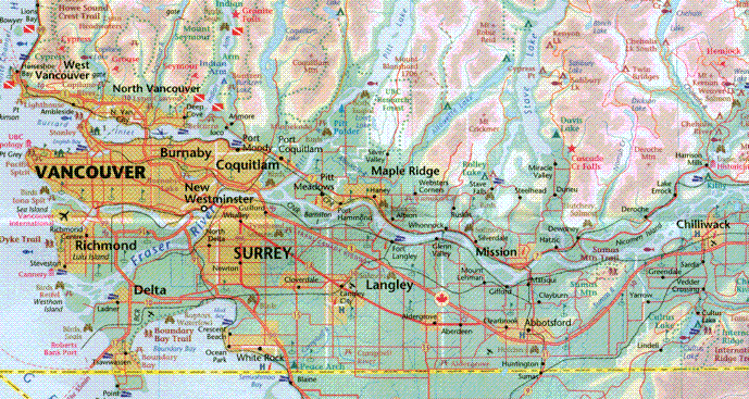
British Columbia is a province of superlatives—towering mountains, vast forests, rugged coastlines, and winding wilderness highways. The British Columbia Map by ITMB (International Travel Maps) offers a comprehensive and easy-to-read overview of the entire province, making it one of our best-selling regional maps for adventure seekers, road trippers, and logistics planners alike.
This most recent edition includes a major update that travellers will appreciate: the newly completed Trans-Canada Highway (TC-1) upgrade between the Alberta border and Golden. Now a full motorway-standard route, this stretch—one of the most challenging highway projects in Canadian history—is shown in its updated form on this map.
Whether you're heading for the Rockies, exploring Vancouver Island, or venturing into the Cariboo or Skeena regions, this high-detail map is the ultimate companion for understanding the landscape, planning routes, and navigating British Columbia’s vast distances.
🗺️ Key Features
🛣️ Updated Road Network
-
Full provincial coverage at 1:1,250,000 scale
-
Newly completed Trans-Canada Highway upgrade from Alberta to Golden now shown
-
Major and minor roads, highways, forestry routes, and ferry connections included
-
Ideal for self-drive holidays, truckers, RV users, and regional planning
🚆 Rail and Infrastructure
-
Rail lines and key freight corridors marked
-
Locations of border crossings, ferry ports, and mountain passes
-
Index of place names for quick referencing of towns, regions, and junctions
🌲 Topographic & Regional Highlights
-
Shaded relief to show mountainous terrain and elevation changes
-
Lakes, rivers, parks, and ecological reserves clearly labelled
-
National Parks such as Yoho, Glacier, Kootenay, Jasper (partial), and Pacific Rim featured
🏞️ Points of Interest
-
Indigenous communities, heritage sites, and natural landmarks
-
Ideal for outdoor adventurers: hiking, camping, fishing, or wildlife tours
-
Shows distances, remote towns, and coastal settlements from Prince Rupert to Fernie
📏 Product Specifications
| Feature | Details |
|---|---|
| Map Title | British Columbia Provincial Map – ITMB |
| Publisher | International Travel Maps (Canada) |
| Scale | 1:1,250,000 |
| Size (Unfolded) | 690mm (W) x 1000mm (H) |
| Format | Folded map (laminated version optional) |
| Edition | Most recent with Trans-Canada update (2024) |
| Language | English |
| Printed In | Canada 🇨🇦 |
🧳 Who Should Use This Map?
-
🚙 Road Trippers & Overlanders – Drive with confidence across BC’s dramatic terrains
-
🚚 Truck Drivers & Caravanners – Stay updated on highway upgrades and mountain routes
-
🧭 Outdoor Enthusiasts – Navigate remote regions with accuracy for hiking, camping & kayaking
-
🏞️ National Park Explorers – Use for route planning into wilderness areas and eco-reserves
-
📚 Students & Map Collectors – A fantastic addition to Canadian cartographic collections
✨ Lamination Option Available
Upgrade to a laminated version for added durability and interactivity:
-
✅ Write-on/wipe-off surface – Use whiteboard markers for route planning
-
✅ Perfect for map dots – Highlight destinations and track progress
-
✅ Tear-resistant and stain-proof – Designed for life on the road or wall display
-
🛠️ Note: Laminated maps are flattened folded maps, so light crease lines may still be visible.
🛒 Add to Cart – Chart Your BC Adventure Today
From the glass towers of Vancouver to the glacial passes of the Rockies, British Columbia is a land meant to be explored — and this ITMB map ensures you do it with clarity, detail, and confidence.
Whether you’re mapping your next wilderness escape or hanging it in your planning room, this is the definitive provincial map of BC.
Add to cart now, and let the mountains, lakes, and roads of Canada's Pacific jewel unfold before you.
Frequently Asked Questions
Where can I buy the British Columbia ITMB Map?
The British Columbia ITMB Map is available to buy online from Mapworld, Australia's largest map and geographic product retailer, with fast shipping Australia-wide.
Is the British Columbia ITMB Map in stock at Mapworld?
Mapworld maintains extensive stock across its map range and aims for fast dispatch. Orders placed before 2pm AEST on business days are typically dispatched the same day, with standard and express Australia-wide delivery options available.
What is Mapworld's returns policy?
Mapworld accepts returns on undamaged items in original condition. Contact Mapworld within 90 days of purchase to arrange a return or exchange.
Does Mapworld ship the British Columbia ITMB Map across Australia?
Yes, Mapworld ships Australia-wide. Standard shipping is a flat $7 rate, with free standard shipping on orders over $75. Express options are available at checkout. Most orders placed before 2pm AEST on weekdays are dispatched same day.
Related Items


© 2026 Mapworld. Website designed by Genie Media
X