- Australia ▾
- Topographic
▾
- Australia AUSTopo 250k (2025)
- Australia 50k Geoscience maps
- Australia 100k Geoscience maps
- Australia 250k Geoscience maps
- Australia 1:1m Geoscience maps
- New Zealand 50k maps
- New Zealand 250k maps
- New South Wales 25k maps
- New South Wales 50k maps
- New South Wales 100k maps
- Queensland 10k maps
- Queensland 25k maps
- Queensland 50k maps
- Queensland 100k maps
- Western Australia 25k maps
- Western Australia 50k maps
- Western Australia 100k maps
- Compasses
- Software
- GPS Systems
- International ▾
- Wall Maps
▾
- World
- Australia & New Zealand
- Countries, Continents & Regions
- Historical
- Vintage National Geographic
- Australian Capital Territory
- New South Wales
- Northern Territory
- Queensland
- South Australia
- Tasmania
- Victoria
- Western Australia
- Celestial
- Children's
- Mining & Resources
- Wine Maps
- Healthcare
- Postcode Maps
- Electoral Maps
- Nautical ▾
- Flags
▾
- Australian Flag Sets & Banners
- Flag Bunting
- Handwavers
- Australian National Flags
- Aboriginal Flags
- Torres Strait Islander Flags
- International Flags
- Flagpoles & Accessories
- Australian Capital Territory Flags
- New South Wales Flags
- Northern Territory Flags
- Queensland Flags
- South Australia Flags
- Tasmania Flags
- Victoria Flags
- Western Australia Flags
- Gifts ▾
- Globes ▾
Dear valued customer. Please note that our checkout is not supported by old browsers. Please use a recent browser to access all checkout capabilities


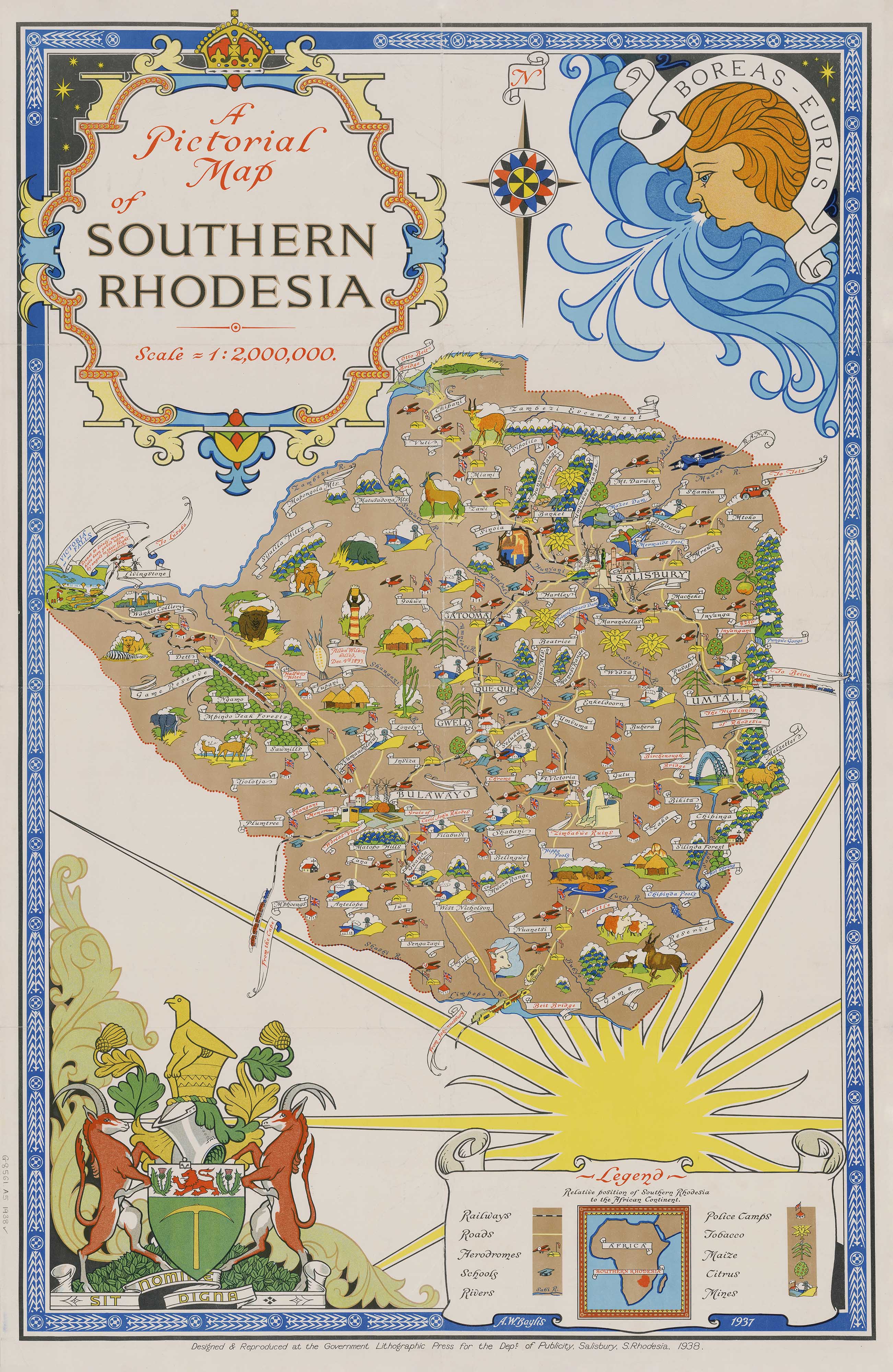
Southern Rhodesia Wall Map 1937
$59.95
or make 4 interest-free payments of
$14.99 AUD
fortnightly with
![]() More info
More info
Southern Rhodesia — Pictorial Wall Map (1937/1938)
A country rendered in emblem and line—this richly illustrated pictorial map of Southern Rhodesia was designed by A. W. Baylis (1937) and reproduced at the Government Lithographic Press for the Department of Publicity in Salisbury (1938). Vignettes, clear lettering and measured cartography come together to show a landscape of towns, routes and regions as they were seen in the late 1930s. It’s a vivid snapshot of Southern Africa’s past, ready to anchor a room with history and character.
More Than a Map – A Testament to History
This is not just wall art—it’s a period document. Every pictorial motif, title panel and place name reflects the visual language and geography of its time. Ideal for historians, educators, collectors, designers and families with ties to the region, it invites reflection, study and conversation about how places were portrayed and understood.
Display it in classrooms, offices, museums, libraries or your home to spark learning and remembrance.
Premium Materials & Finishes
We treat history with the respect it deserves. Choose from formats produced with archival methods for beauty that lasts.
Archival Paper Print
Printed on heavyweight 160gsm archival-grade paper.
A smooth matte finish reduces glare and preserves fine linework—ideal for framing under glass.
Laminated Edition
Encapsulated in two 80-micron gloss laminate sheets using true thermal bonding (not surface film).
Moisture-resistant, wipe-clean durability for schools, offices and high-traffic spaces.
Optional Natural Timber Hang Rails: lacquered rails with a fitted cord deliver a polished, ready-to-hang presentation. (Please allow up to 10 working days for delivery with hang rails.)
Museum-Quality Canvas
Printed on 395gsm HP Professional Matte Canvas for rich texture and strength.
Pigment-based, fade-resistant inks ensure vibrant colour and crisp labels for generations.
Optional Natural Timber Hang Rails: lacquered to enhance the grain, with a top cord for effortless hanging—timeless and elegant. (Please allow up to 10 working days for delivery with hang rails.)
Specifications
| Feature | Details |
|---|---|
| Original Publication | Designed 1937 (A. W. Baylis); reproduced 1938 |
| Publisher/Printer | Government Lithographic Press for the Department of Publicity, Salisbury |
| Title | Southern Rhodesia — Pictorial Map |
| Style | Pictorial/illustrated cartography |
| Map Size | 950 mm (W) × 620 mm (H) |
| Available Formats | Paper, Laminated, Canvas |
| Paper Weight | 160gsm archival-quality |
| Laminate | 2 × 80-micron gloss sheets (encapsulated) |
| Canvas Weight | 395gsm HP Professional Matte Canvas |
| Inks | Pigment-based, fade-resistant |
| Optional Hang Rails | Available on Laminated & Canvas versions |
| Origin | Made in Australia |
Why Choose This Map
✔ Pictorial Charm & Clarity: Illustrated motifs and clean lettering balance display appeal with legibility.
✔ A Historical Window: Presents pre-independence geography and period place names in authentic style.
✔ Crafted to Last: Premium substrates and archival inks preserve colour and linework for decades.
✔ Ready to Display: Optional hang-railed laminated or canvas editions offer a museum-quality look—no framing required.
✔ A Thoughtful Gift: Perfect for historians, collectors and anyone connected to Southern African heritage.
Our Commitment
We believe preserving history is as important as telling it. Every map is printed locally in Australia using state-of-the-art technology, carefully checked by hand, and packed with care. From our workshop to your wall, we ensure quality you can trust and a legacy you’ll be proud to share.
Bring this evocative Southern African portrait into your space. Order the Southern Rhodesia — Pictorial Wall Map (1937/1938) today—a faithful, beautifully produced record of place and time.
Frequently Asked Questions
What are the dimensions of the Southern Rhodesia Wall Map 1937?
Mapworld wall maps range from standard 700×1000mm to large-format 1000×1430mm Supermaps. The exact dimensions for this map are shown in the product title. Where multiple sizes are available, select your preferred size when adding to cart.
Is this wall map available laminated?
Many Mapworld wall maps are available in paper, laminated, or framed finishes. Check the product options when adding to cart. Laminated maps are wipe-clean and more durable.
Is this the latest edition?
Mapworld stocks the most current editions available from all publishers. Edition year is shown in the product title where applicable. Mapworld updates its catalogue as new editions are released.
Can I write on or pin this wall map?
Laminated wall maps can be written on with whiteboard markers and wiped clean. Paper maps can be pinned on a corkboard. Choose a laminated option for a writeable surface.
Does Mapworld ship the Southern Rhodesia Wall Map 1937 across Australia?
Yes, Mapworld ships Australia-wide. Standard shipping is a flat $7 rate, with free standard shipping on orders over $75. Express options are available at checkout. Most orders placed before 2pm AEST on weekdays are dispatched same day.
Related Items


© 2026 Mapworld. Website designed by Genie Media
X