- Australia ▾
- Topographic
▾
- Australia AUSTopo 250k (2025)
- Australia 50k Geoscience maps
- Australia 100k Geoscience maps
- Australia 250k Geoscience maps
- Australia 1:1m Geoscience maps
- New Zealand 50k maps
- New Zealand 250k maps
- New South Wales 25k maps
- New South Wales 50k maps
- New South Wales 100k maps
- Queensland 10k maps
- Queensland 25k maps
- Queensland 50k maps
- Queensland 100k maps
- Compasses
- Software
- GPS Systems
- Orienteering
- International ▾
- Wall Maps
▾
- World
- Australia & New Zealand
- Countries, Continents & Regions
- Historical
- Vintage National Geographic
- Australian Capital Territory
- New South Wales
- Northern Territory
- Queensland
- South Australia
- Tasmania
- Victoria
- Western Australia
- Celestial
- Children's
- Mining & Resources
- Wine Maps
- Healthcare
- Postcode Maps
- Electoral Maps
- Nautical ▾
- Flags
▾
- Australian Flag Sets & Banners
- Flag Bunting
- Handwavers
- Australian National Flags
- Aboriginal Flags
- Torres Strait Islander Flags
- International Flags
- Flagpoles & Accessories
- Australian Capital Territory Flags
- New South Wales Flags
- Northern Territory Flags
- Queensland Flags
- South Australia Flags
- Tasmania Flags
- Victoria Flags
- Western Australia Flags
- Gifts ▾
- Globes ▾
Dear valued customer. Please note that our checkout is not supported by old browsers. Please use a recent browser to access all checkout capabilities


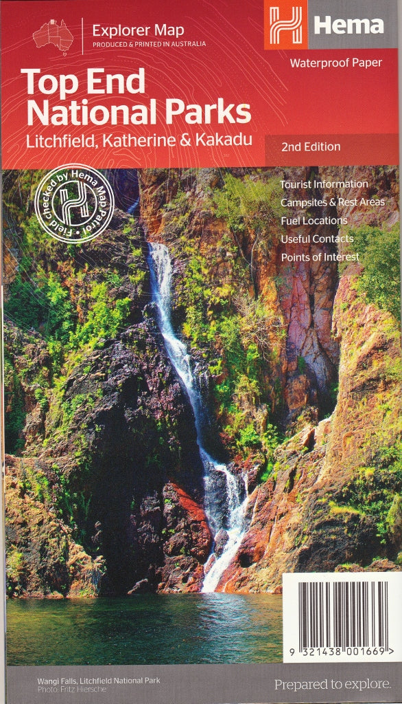
Top End National Parks Map by Hema Maps – 2nd Edition
$14.95 $15.95
Afterpay is only available for orders between $50.00 and $1000.00 More info
Your Ultimate Companion to Australia’s Tropical North
Explore the wild, ancient beauty of the Northern Territory’s Top End with this detailed, double-sided map from Hema—Australia’s most trusted adventure cartographers. From cascading waterfalls and sacred rock art sites to lush monsoon forests and remote 4WD tracks, the Top End National Parks Map is designed for travellers who crave more than just the open road.
Whether you’re navigating the croc-infested billabongs of Kakadu, plunging into crystal-clear pools at Litchfield, or paddling through the awe-inspiring gorges of Nitmiluk (Katherine Gorge), this map offers the clarity, durability, and detail to make your journey safe, informed, and unforgettable.
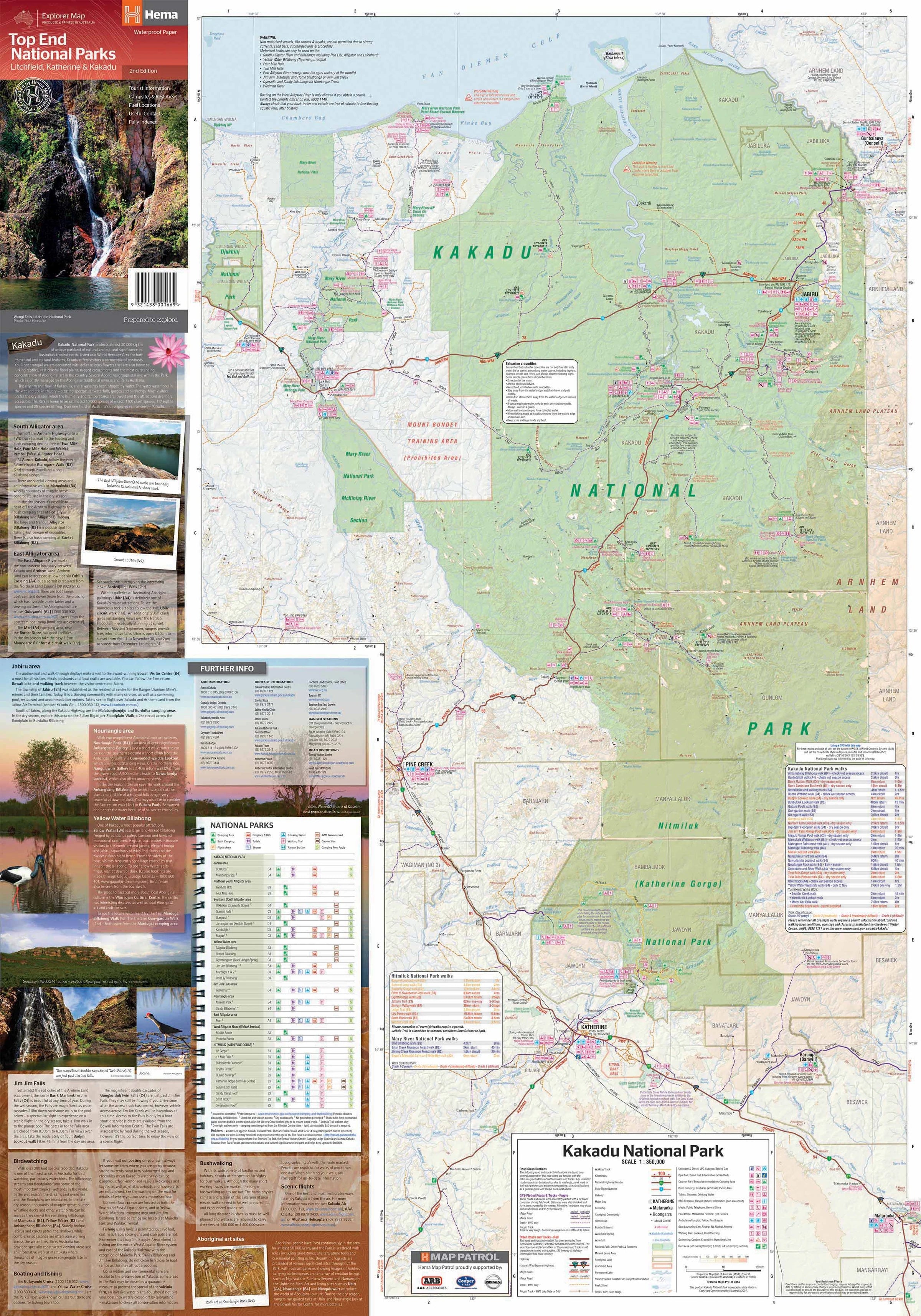
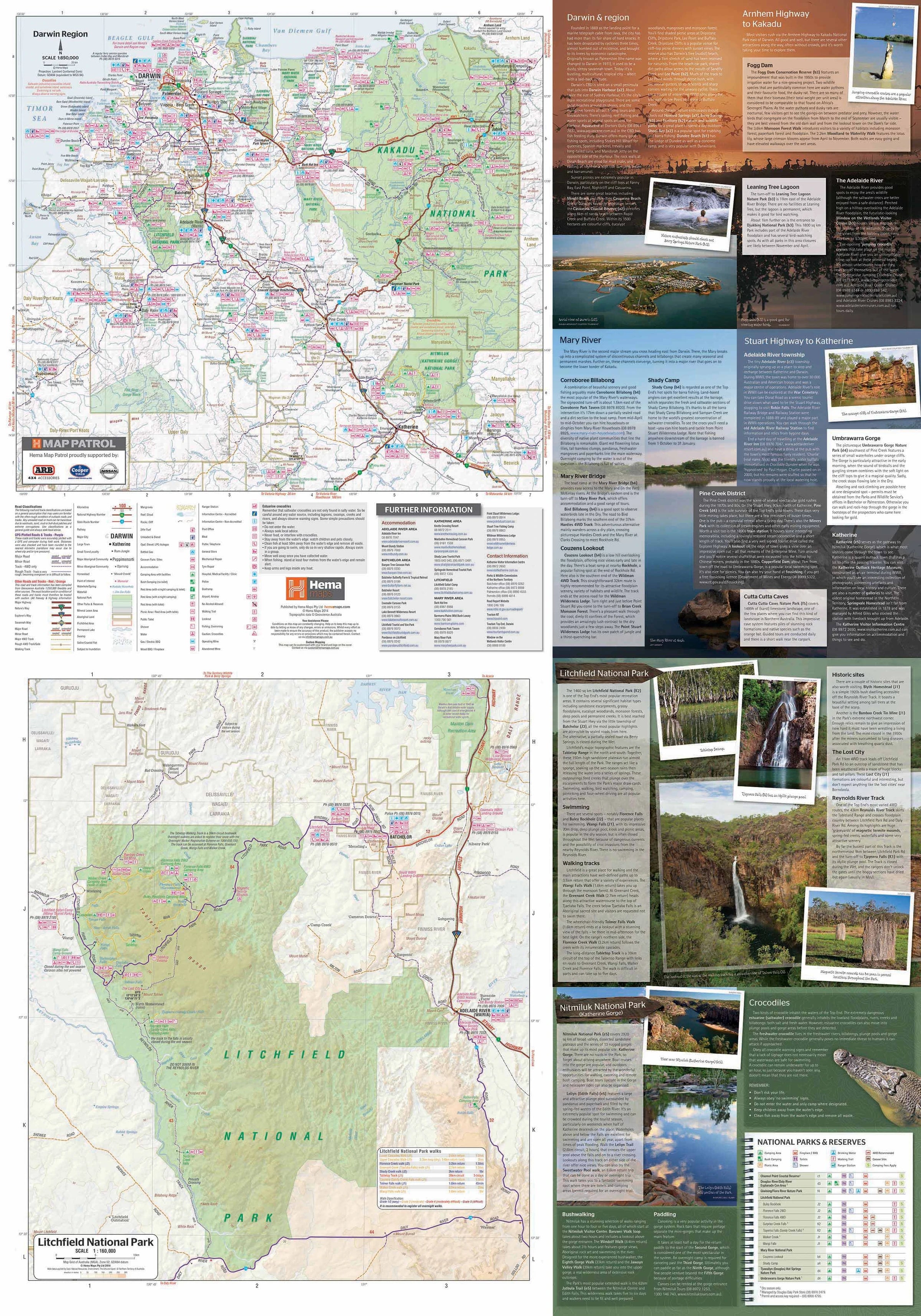
🗺️ Regional Coverage & Mapping Scales
Each featured park is rendered at a scale that balances fine detail with navigational clarity:
| Region | Scale |
|---|---|
| Litchfield National Park | 1:160,000 |
| Kakadu & Nitmiluk National Parks | 1:350,000 |
| Darwin & Surrounds Overview | 1:850,000 |
These maps cover not just the parks but also connecting routes from Darwin, the Stuart and Arnhem Highways, and all surrounding access tracks—ensuring you’re never lost, even in the wildest corners of the Top End.
🧭 Key Map Features
-
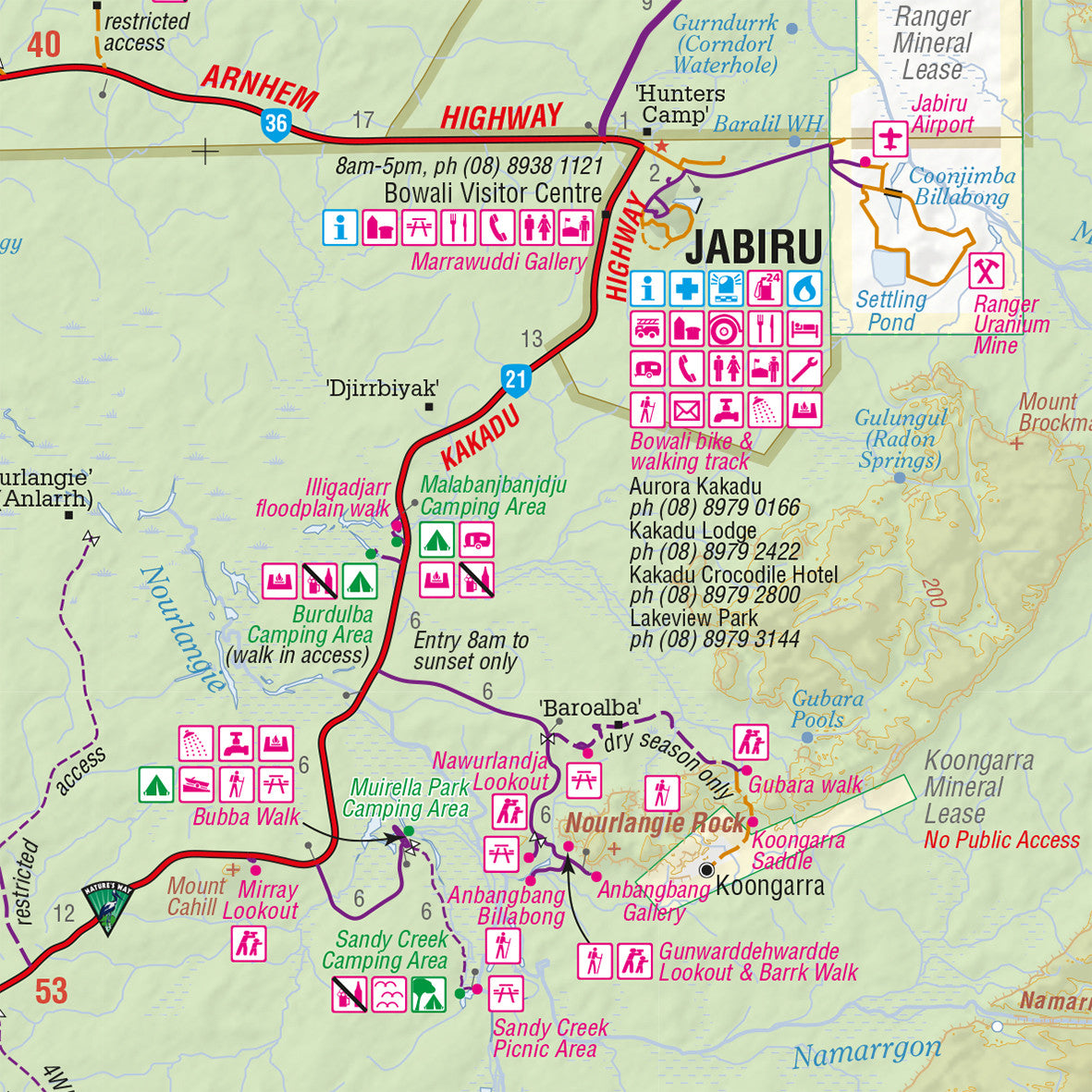
🚗 All Roads and 4WD Tracks clearly marked and classified by condition
-
🗺️ Tourist Drives & Scenic Loops for leisurely road tripping
-
🚦 Park Entry Points & Boundaries for easy planning
-
🛖 Aboriginal Lands & Permits indicated where required
-
⛺ Campsites, Rest Areas & Visitor Facilities including toilets, fuel, and info centres
-
🥾 Walking Trails, Waterfalls & Plunge Pools like Florence Falls, Gunlom, and Twin Falls
-
🔍 Lookouts, Rock Art Sites & Points of Interest such as Ubirr, Nourlangie, and Edith Falls
-
🌄 Topographic Relief Shading helps visualise elevation and terrain—essential for hikers and 4WD route planning
With GPS-verified accuracy and thoughtful presentation, the map is tailored for self-guided touring, off-grid camping, and bush exploration.
📚 Reverse Side Tourist Guide
This map is more than just a cartographic tool—it’s a mini travel guide that includes:
-
📌 Park Rules, Fees & Contacts for each destination
-
☀️ Seasonal Travel Advice for both dry and wet seasons
-
🐊 Wildlife Spotting Tips including birdlife and crocodile safety notes
-
🧭 Cultural Background of the Jawoyn, Wagait, Limilngan, and Bininj/Mungguy peoples
-
🚗 Travel Routes from Darwin, Katherine, and regional towns
-
📖 Cultural Sites & Sacred Areas respectfully noted to enhance understanding
Perfect for first-time visitors and seasoned explorers alike, this guide brings the stories of the land to life while helping you travel safely and respectfully.
📐 Map Specifications
| Specification | Details |
|---|---|
| Edition | 2nd |
| Publisher | Hema Maps |
| Publication Date | 2014 |
| Material | Waterproof, tear-resistant synthetic paper |
| Map Style | Double-sided, full-colour print |
| Folded Size | 140 mm x 250 mm |
| Unfolded Size | 1000 mm x 700 mm |
| Weight | Approx. 90 g |
🧳 Perfect For
-
🛻 4WD Adventurers navigating Kakadu’s seasonal roads and remote camps
-
🏕️ Campers & Caravanners seeking hidden spots with amenities
-
🥾 Hikers & Backpackers exploring bush trails and escarpments
-
📸 Photographers & Nature Lovers chasing waterfalls and wildlife
-
🎓 Educators & Cultural Tourists engaging with Indigenous heritage
-
🌴 Road Trippers taking in the beauty of the Top End’s tropical landscapes
💬 Why Choose the Hema Top End National Parks Map?
✔️ Field-tested & GPS-verified by the Hema Map Patrol
✔️ Waterproof and tear-resistant—ideal for Top End humidity and sudden downpours
✔️ Rich with practical info: fuel, permits, camps, walking trails, and more
✔️ Showcases both natural beauty and cultural significance
✔️ Combines navigation, safety, education, and storytelling in one lightweight foldout
🔒 Optional Laminated Upgrade
We also offer this map as a laminated version, encapsulated in high-quality 80-micron gloss laminate. This option is:
-
💧 Waterproof & Smudge-Proof
-
🖊️ Writable with whiteboard markers for route planning
-
🧳 Durable & Reusable — ideal for long trips, groups, and tour operators
-
🌀 Easy to Roll Up or Display in your 4WD, caravan, or classroom
Please note: Fold lines may be faintly visible under the lamination, but the durability is unmatched.
🌿 Explore Australia’s Living Heart
Stand in the spray of Jim Jim Falls. Glide silently through Katherine Gorge. Watch the red rock glow at sunset over Ubirr. With this map in hand, you don’t just visit the Top End—you understand it, you honour it, and you experience it deeply.
Travel smart. Respect Country. Go prepared. Go with Hema.
Frequently Asked Questions
What does the Top End National Parks Map by Hema Maps – 2nd Edition cover?
The Top End National Parks Map by Hema Maps – 2nd Edition covers 4WD tracks, camping areas, and travel routes for the region described in the product title. Most 4WD and camping guides in Mapworld's range include GPS coordinates, distance information, difficulty ratings, and notes on fuel stops and emergency contact points.
Is the Top End National Parks Map by Hema Maps – 2nd Edition up to date?
Yes, this is the current edition. Mapworld stocks current editions from publishers including Hema Maps, Westprint, and others.
Is this product suitable for remote area travel?
Yes, 4WD maps and guides are designed for remote area navigation and trip planning. They include track conditions, fuel availability, camping spots, and safety information.
Does Mapworld ship the Top End National Parks Map by Hema Maps – 2nd Edition across Australia?
Yes, Mapworld ships Australia-wide. Standard shipping is a flat $7 rate, with free standard shipping on orders over $75. Express options are available at checkout. Most orders placed before 2pm AEST on weekdays are dispatched same day.
Related Items


© 2026 Mapworld. Website designed by Genie Media
X