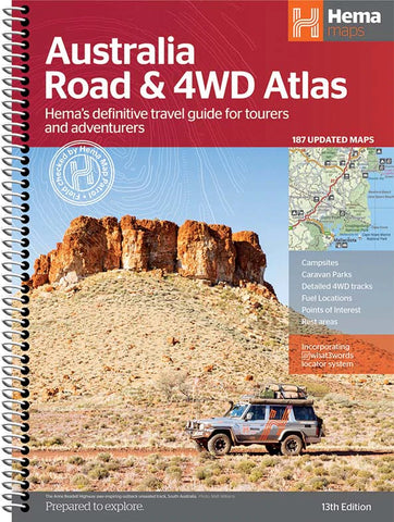
- Australia ▾
- Topographic
▾
- Australia AUSTopo 250k (2025)
- Australia 50k Geoscience maps
- Australia 100k Geoscience maps
- Australia 250k Geoscience maps
- Australia 1:1m Geoscience maps
- New Zealand 50k maps
- New Zealand 250k maps
- New South Wales 25k maps
- New South Wales 50k maps
- New South Wales 100k maps
- Queensland 10k maps
- Queensland 25k maps
- Queensland 50k maps
- Queensland 100k maps
- Compasses
- Software
- GPS Systems
- Orienteering
- International ▾
- Wall Maps
▾
- World
- Australia & New Zealand
- Countries, Continents & Regions
- Historical
- Vintage National Geographic
- Australian Capital Territory
- New South Wales
- Northern Territory
- Queensland
- South Australia
- Tasmania
- Victoria
- Western Australia
- Celestial
- Children's
- Mining & Resources
- Wine Maps
- Healthcare
- Postcode Maps
- Electoral Maps
- Nautical ▾
- Flags
▾
- Australian Flag Sets & Banners
- Flag Bunting
- Handwavers
- Australian National Flags
- Aboriginal Flags
- Torres Strait Islander Flags
- International Flags
- Flagpoles & Accessories
- Australian Capital Territory Flags
- New South Wales Flags
- Northern Territory Flags
- Queensland Flags
- South Australia Flags
- Tasmania Flags
- Victoria Flags
- Western Australia Flags
- Gifts ▾
- Globes ▾
Dear valued customer. Please note that our checkout is not supported by old browsers. Please use a recent browser to access all checkout capabilities


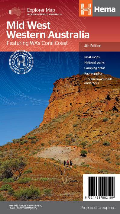
Hema Mid West Western Australia Map – 4th Edition
$14.95
Afterpay is only available for orders between $50.00 and $1000.00 More info
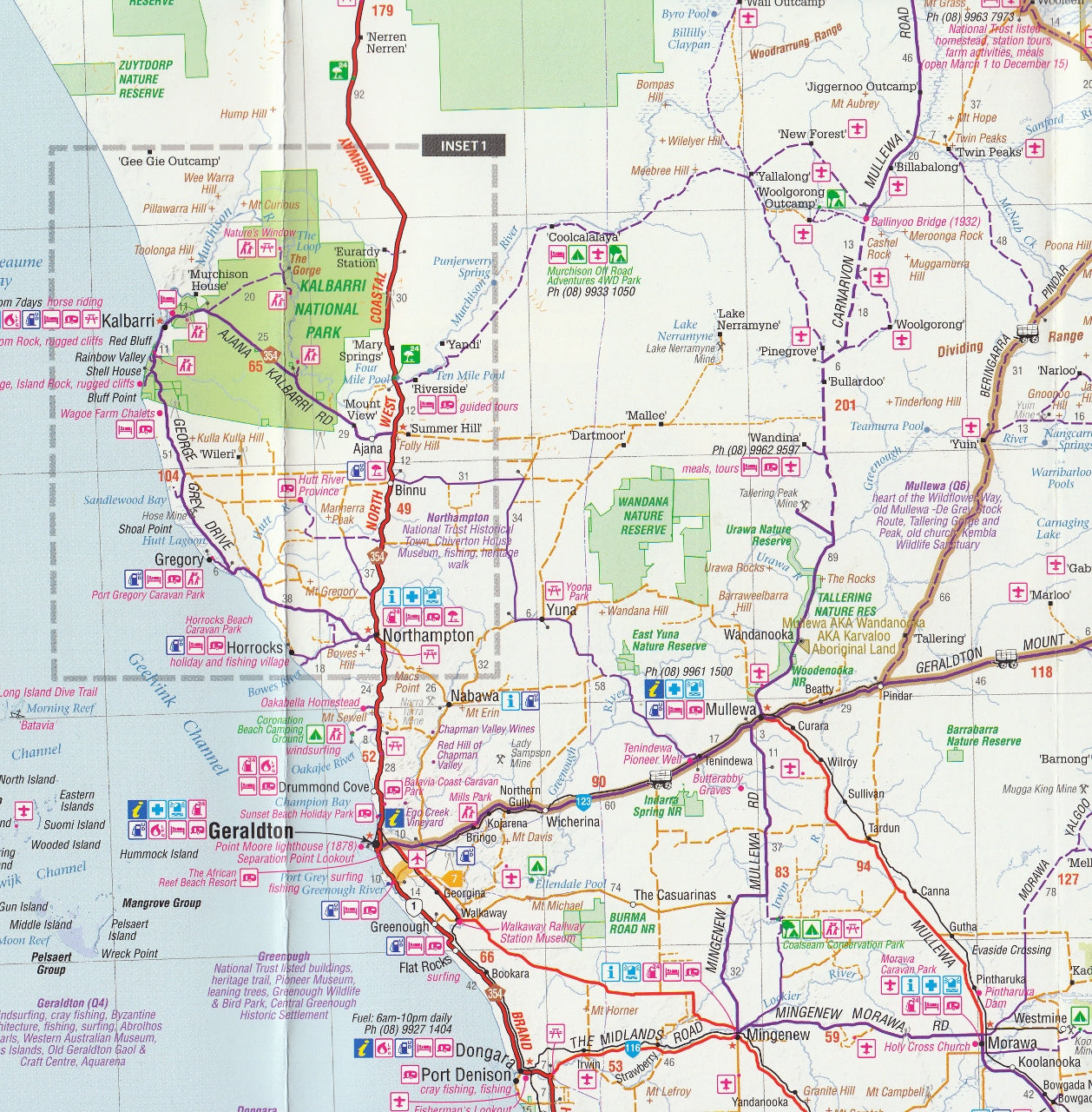
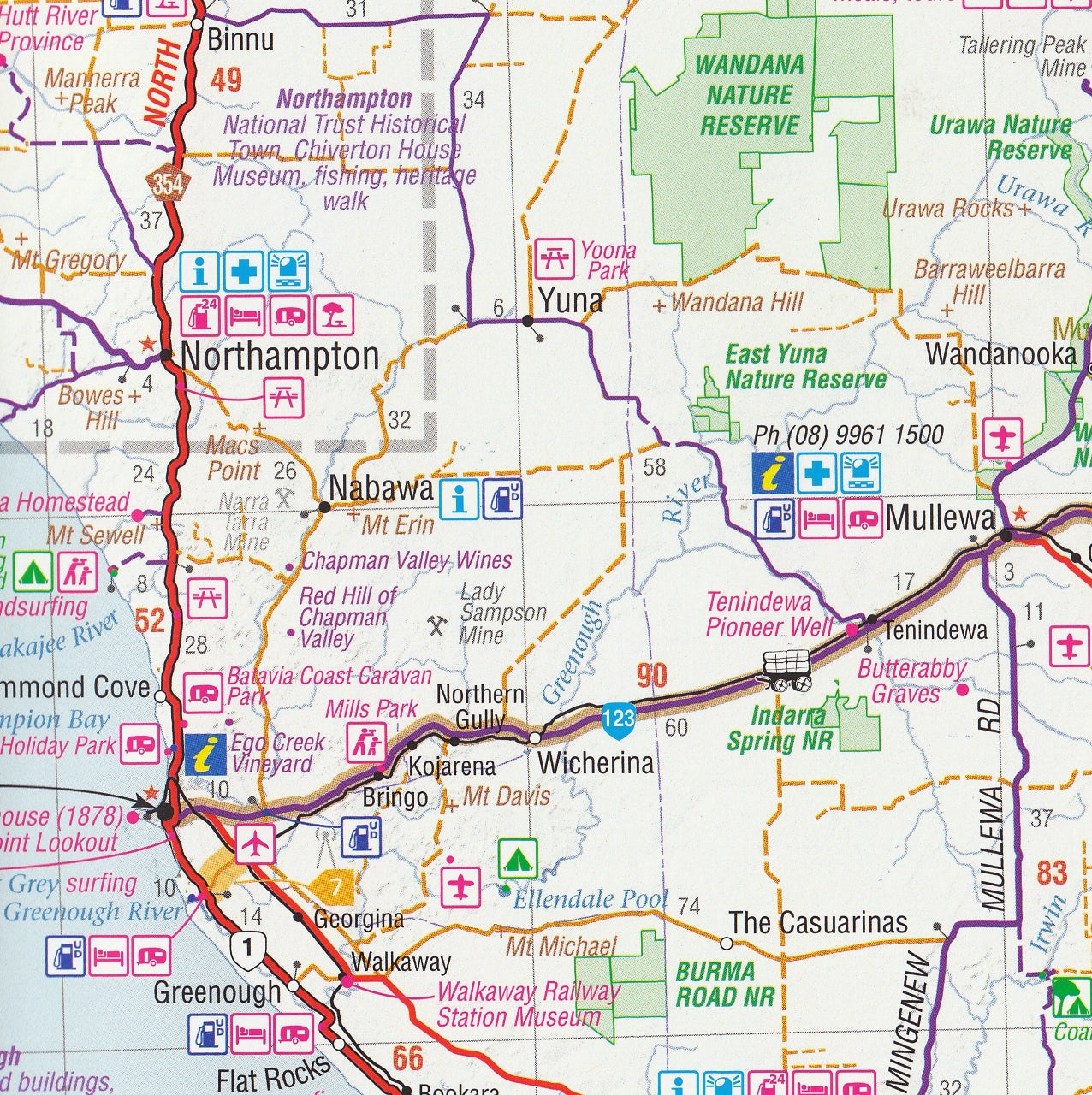
Your essential guide to the rugged beauty, remote roads, and natural wonders of WA’s vast Mid West region.
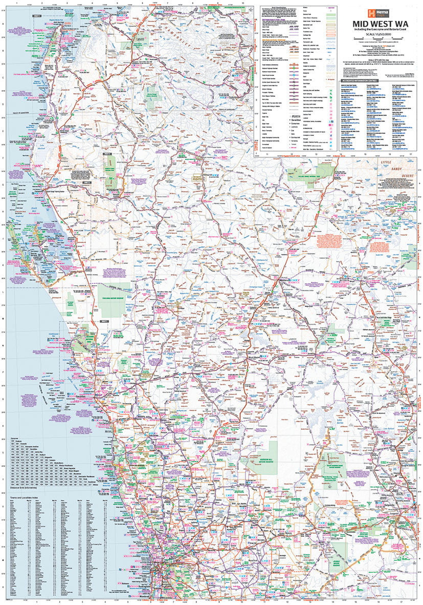
The Mid West Western Australia Map by Hema Maps is a detailed, double-sided touring map that offers comprehensive coverage of Western Australia’s expansive and diverse Mid West region. Whether you're planning a 4WD adventure, a coastal road trip, a wildflower trail, or a deep dive into WA’s national parks, this map is an indispensable tool that combines practical navigation with region-specific travel information.
Spanning from Cape Range National Park in the north to Mandurah in the south and as far east as Kalgoorlie, this map includes the spectacular Coral Coast, remote desert interiors, and outback icons like Mount Augustus and the Kennedy Range.
🗺️ Area Coverage
This wide-ranging map offers excellent regional context, with key towns and destinations including:
-
Geraldton
-
Kalbarri
-
Carnarvon
-
Exmouth & Cape Range National Park
-
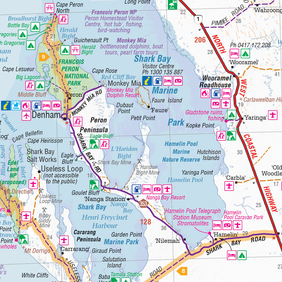
Francois Peron National Park
-
Meekatharra
-
Mount Augustus
-
Kennedy Range
-
Murchison
-
Kalgoorlie & the Goldfields
-
Greenough, Dongara, Northampton
-
Coastal hubs and inland stations across the Gascoyne and Pilbara regions
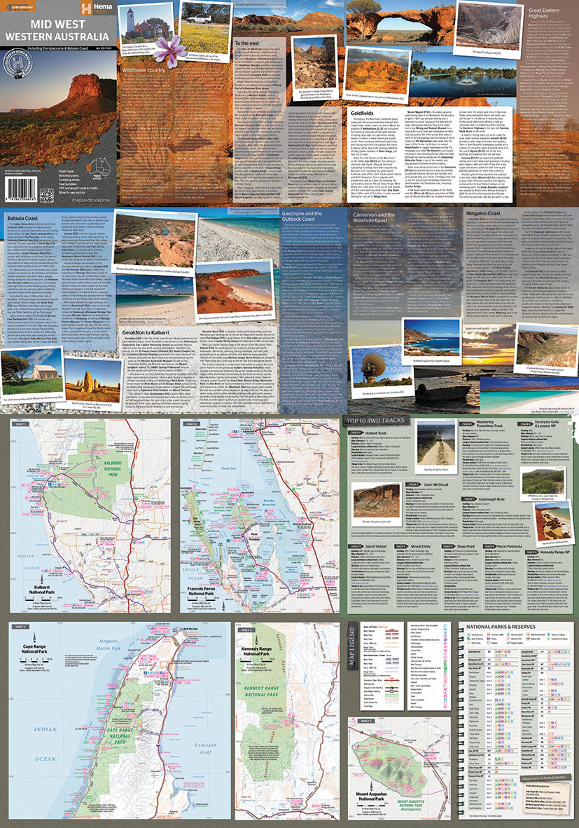
🌿 Inset National Park Maps
To help you navigate WA’s most iconic wilderness areas, the map includes detailed inset mapping of:
-
Cape Range National Park
-
Kalbarri National Park
-
Francois Peron National Park
-
Kennedy Range National Park
-
Mount Augustus National Park
These insets highlight walking trails, campsites, lookouts, access roads, and natural attractions—making the map an excellent tool for self-guided exploration.
🚙 Top 10 4WD Tracks
The map features a handpicked selection of the best 4WD experiences in the region, with detailed notes and route markers for:
-
Holland Track
-
Cave Hill Circuit
-
Jaurdi Station Loop
-
Mount Elvire Track
-
Mundaring Powerlines Track
-
Stockyard Gully & Lesueur National Park
-
Greenough River Drive
-
Steep Point Track
-
Peron Peninsula Adventure Loop
-
Kennedy Range Exploration Route
Each of these routes is marked on the map with surface types, key stops, and access points, giving both novice and experienced drivers the confidence to plan safe and scenic off-road journeys.
🛠️ Practical Features
-
Scale: 1:1,250,000
-
GPS-Surveyed Roads and Tracks: Trusted accuracy from Hema’s field mapping teams
-
Road Types: Sealed, unsealed, and 4WD-only routes clearly marked
-
Fuel Stops, Campsites & Rest Areas: All major stops plotted, with practical symbols for facilities
-
National Parks, Reserves & Indigenous Lands: Outlined with entry and permit information
-
Topographic Relief Shading: To highlight terrain and elevation changes
-
Touring Regions Highlighted: Includes info panels on:
-
Wildflower Country
-
Batavia Coast
-
Goldfields
-
Outback Gascoyne
-
Great Eastern Highway
-
The Blowhole Coast
-
Geraldton to Kalbarri
-
📐 Map Specifications
-
Edition: 4th
-
Published: July 1, 2014
-
Format: Double-sided full-colour map
-
Material: Durable, high-quality paper (laminated option often available)
-
Folded Size: 140 mm x 250 mm x 3 mm
-
Flat Size: 700 mm x 1000 mm
-
Weight: ~90 grams
-
Publisher: Hema Maps
-
Made in: Australia
🎯 Who Is This Map For?
-
4WD Tourers: Looking to tackle challenging yet rewarding inland and coastal tracks
-
Campers & Caravanners: Seeking campgrounds, bush camps, and road trip routes
-
Grey Nomads & Long-Haul Road Trippers: Planning extended journeys with reliable route information
-
Wildflower Hunters: Following seasonal blooms through WA’s famed Wildflower Country
-
Nature & History Buffs: Visiting national parks, Aboriginal cultural sites, gorges, and colonial heritage towns
-
Photographers, Travel Writers, and Guides: Looking for off-grid landscapes, outback roads, and local detail
🌏 Why Choose This Map?
-
Field-checked by Hema’s Map Patrol – offering the most trusted off-road cartography in Australia
-
Combines broad regional context with inset precision mapping
-
Highlights the diverse landscapes of Mid West WA—from coral reefs and coastal cliffs to inland deserts and mountain ranges
-
User-friendly symbols, readable fonts, and clear colour-coded topography
-
Compact, durable, and tailored for real-world adventure—not just digital browsing
🧭 Travel With Confidence
Whether you’re watching the sunrise at Mount Augustus, camping beside a billabong in Kennedy Range, or driving to the Blowholes near Carnarvon, the Hema Mid West Western Australia Map will guide you there and back with clarity, reliability, and insight.
From the Coral Coast to the Goldfields—this is the map you want in your glovebox.
Frequently Asked Questions
Where can I buy the Hema Mid West Western Australia Map – 4th Edition?
The Hema Mid West Western Australia Map – 4th Edition is available to buy online from Mapworld, Australia's largest map and geographic product retailer, with fast shipping Australia-wide.
Is the Hema Mid West Western Australia Map – 4th Edition in stock at Mapworld?
Mapworld maintains extensive stock across its map range and aims for fast dispatch. Orders placed before 2pm AEST on business days are typically dispatched the same day, with standard and express Australia-wide delivery options available.
What is Mapworld's returns policy?
Mapworld accepts returns on undamaged items in original condition. Contact Mapworld within 90 days of purchase to arrange a return or exchange.
Does Mapworld ship the Hema Mid West Western Australia Map – 4th Edition across Australia?
Yes, Mapworld ships Australia-wide. Standard shipping is a flat $7 rate, with free standard shipping on orders over $75. Express options are available at checkout. Most orders placed before 2pm AEST on weekdays are dispatched same day.
Related Items


© 2026 Mapworld. Website designed by Genie Media
X