- Australia ▾
- Topographic
▾
- Australia AUSTopo 250k (2025)
- Australia 50k Geoscience maps
- Australia 100k Geoscience maps
- Australia 250k Geoscience maps
- Australia 1:1m Geoscience maps
- New Zealand 50k maps
- New Zealand 250k maps
- New South Wales 25k maps
- New South Wales 50k maps
- New South Wales 100k maps
- Queensland 10k maps
- Queensland 25k maps
- Queensland 50k maps
- Queensland 100k maps
- Compasses
- Software
- GPS Systems
- Orienteering
- International ▾
- Wall Maps
▾
- World
- Australia & New Zealand
- Countries, Continents & Regions
- Historical
- Vintage National Geographic
- Australian Capital Territory
- New South Wales
- Northern Territory
- Queensland
- South Australia
- Tasmania
- Victoria
- Western Australia
- Celestial
- Children's
- Mining & Resources
- Wine Maps
- Healthcare
- Postcode Maps
- Electoral Maps
- Nautical ▾
- Flags
▾
- Australian Flag Sets & Banners
- Flag Bunting
- Handwavers
- Australian National Flags
- Aboriginal Flags
- Torres Strait Islander Flags
- International Flags
- Flagpoles & Accessories
- Australian Capital Territory Flags
- New South Wales Flags
- Northern Territory Flags
- Queensland Flags
- South Australia Flags
- Tasmania Flags
- Victoria Flags
- Western Australia Flags
- Gifts ▾
- Globes ▾
Dear valued customer. Please note that our checkout is not supported by old browsers. Please use a recent browser to access all checkout capabilities


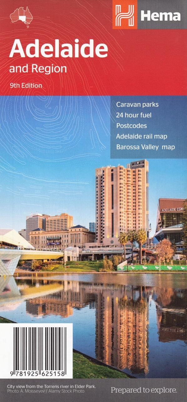
Adelaide & Region Hema Map
$11.95
Afterpay is only available for orders between $50.00 and $1000.00 More info
Double-Sided Travel Map | Greater Adelaide, CBD, Barossa Valley & Fleurieu Peninsula
Scales: 1:80,000 (City) & 1:800,000 (Region) | Size: 700 x 1000 mm | Folded
Whether you’re planning your next road trip through wine country, navigating suburban Adelaide, or coordinating delivery routes across South Australia, the Adelaide & Region Map by Hema Maps is the ultimate compact travel resource.
Combining a detailed metropolitan map with regional coverage of some of South Australia's most iconic destinations, this map is perfect for tourists, educators, local businesses, and logistics professionals alike.
🧭 Key Features
| ✔️ Feature | 💬 Description |
|---|---|
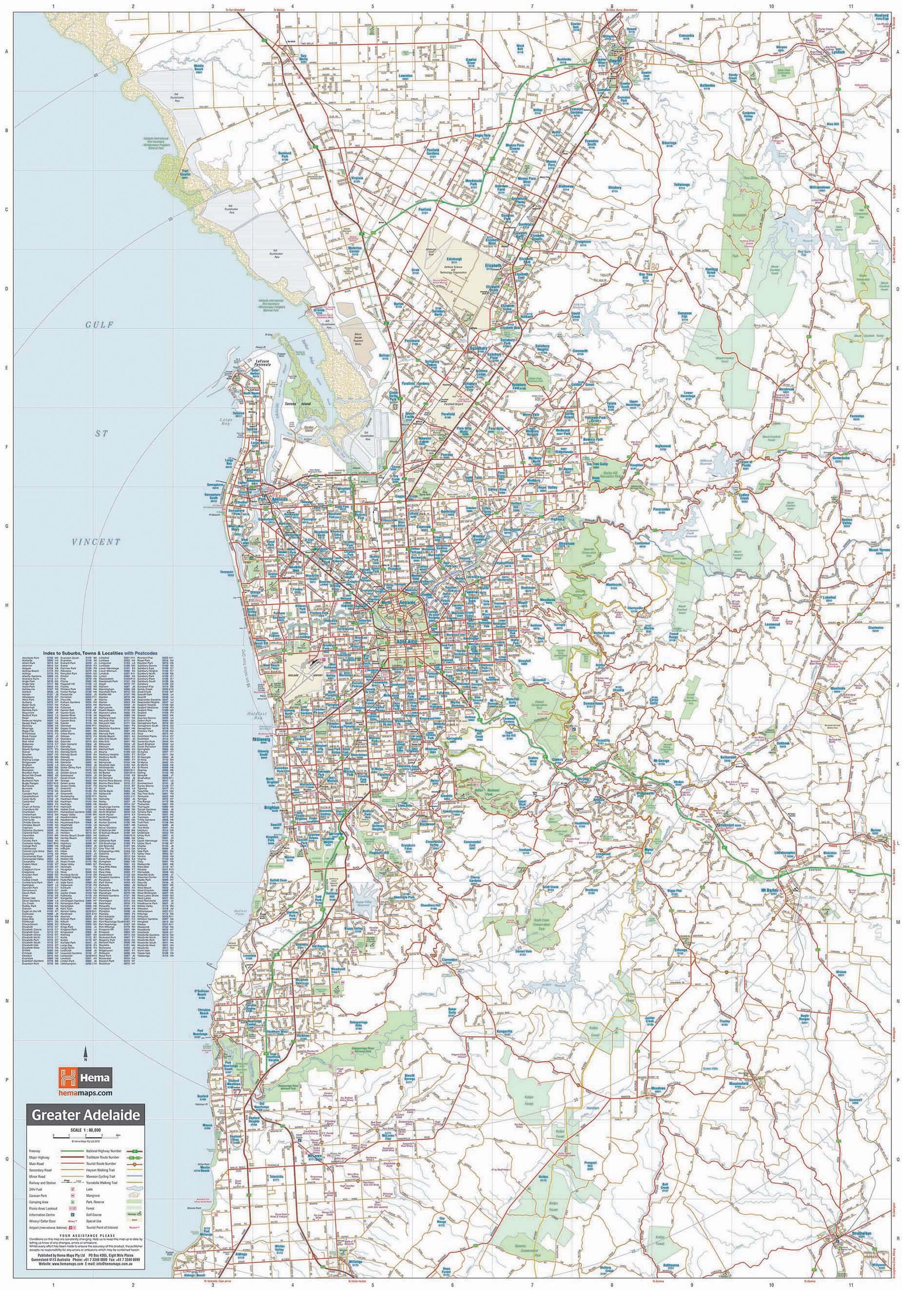
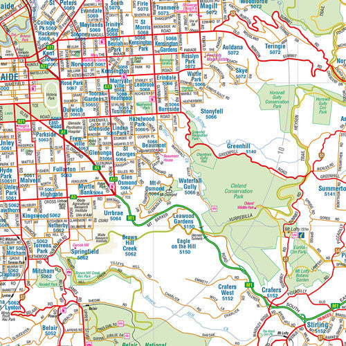
| 🏙️ Greater Adelaide Map | Covers metropolitan Adelaide, the Hills, and surrounding suburbs at a scale of 1:80,000 |
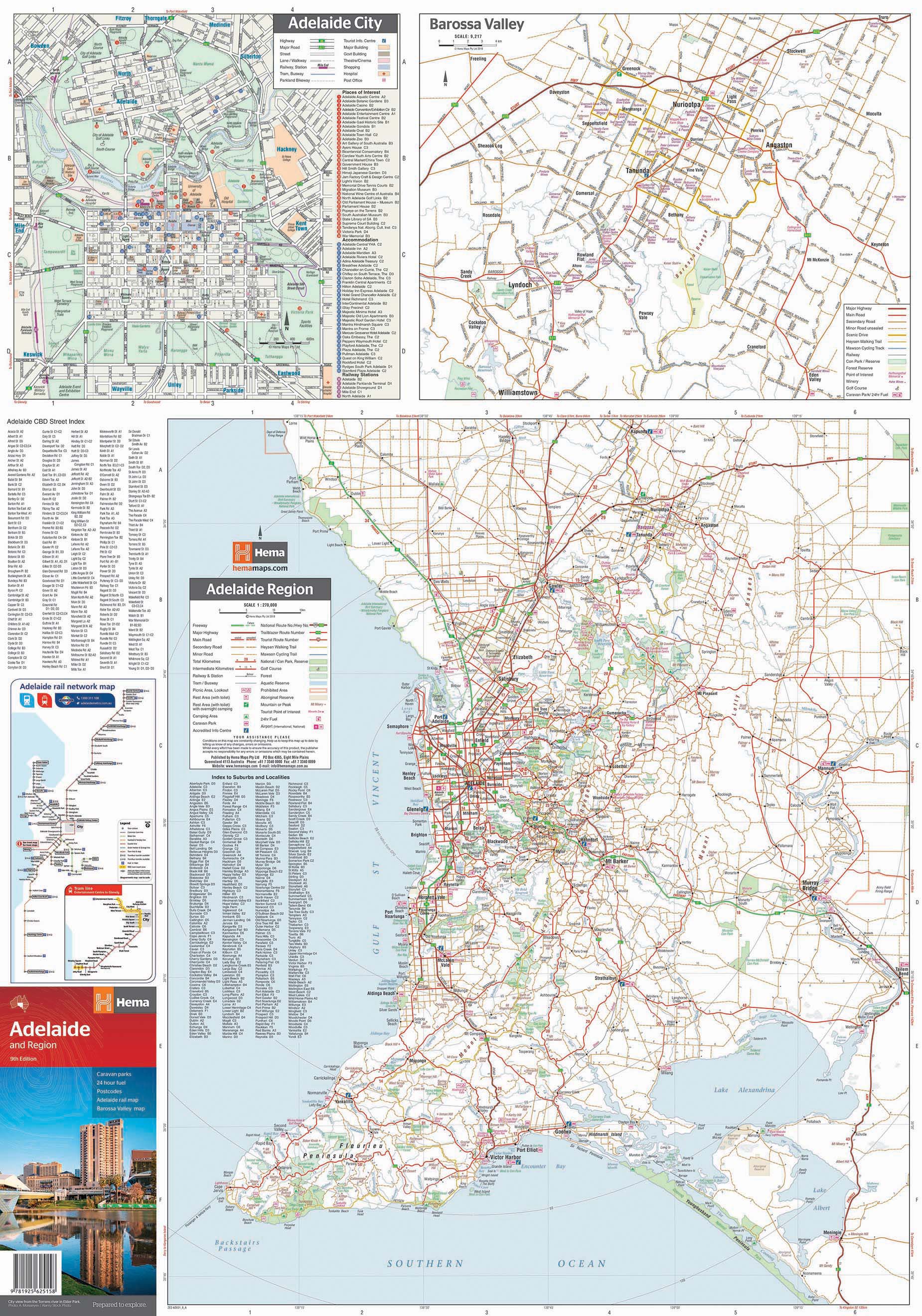
| 🏞️ Regional Touring Map | Broader regional coverage including the Barossa Valley and Fleurieu Peninsula at 1:800,000 |
| 🏘️ Adelaide CBD Inset | A zoomed-in, highly detailed city centre map showing streets, buildings, and landmarks |
| 🍇 Barossa Valley Map | Touring-focused map of South Australia’s famous wine region, highlighting roads, cellar doors, and attractions |
| 🚉 Rail Map | Clear marking of Adelaide’s suburban rail network for commuters and visitors |
| ⛽ 24-Hour Fuel Locations | Convenient markers to assist with route planning and long-haul drives |
| 🛣️ Major Road Networks | Includes highways, arterial roads, secondary and minor roads for complete travel planning |
| 📍 Tourist Attractions | Iconic locations, parks, reserves, towns, lookouts, wineries, and more |
| 📊 Distance Grid | Use the included grid to estimate distances between towns and key landmarks |
| 📇 Indexed Towns & Localities | Fully indexed with suburb and town names for quick reference |
📍 Coverage Areas Include:
-
Metropolitan Adelaide (central suburbs and major arterial routes)
-
Adelaide Hills (Mount Barker, Hahndorf, Stirling, and surrounds)
-
Barossa Valley (Tanunda, Nuriootpa, Angaston, Lyndoch)
-
Fleurieu Peninsula (Victor Harbor, McLaren Vale, Goolwa, Yankalilla, Cape Jervis)
-
Adelaide CBD (dedicated city map with fine street detail)
-
Suburban Rail Network (ideal for route mapping and public transport planning)
📐 Product Specifications
| Specification | Detail |
|---|---|
| Publisher | Hema Maps |
| Edition | Latest available |
| Format | Folded, double-sided paper map |
| Map Scales | 1:80,000 (Greater Adelaide), 1:800,000 (Regional overview) |
| Unfolded Size | 700 mm (W) × 1000 mm (H) |
| Folded Size | 125 mm (W) × 250 mm (H) |
| Material | Durable full-colour paper |
| Weight | Approx. 70 g |
| ISBN | 9781865007779 |
| Made in | Australia |
🧳 Who Is This Map For?
-
🚗 Self-drive travellers and weekenders exploring South Australia's wine, coast, and city
-
🛻 Delivery drivers and field services needing efficient suburb-to-suburb routing
-
🏡 Real estate professionals and tradies planning service zones and coverage
-
🧭 Grey nomads and caravaners heading into the Barossa or along the coast
-
🏫 Educators and students studying urban geography and regional topography
-
🧳 Tourists and festivalgoers navigating Adelaide’s busy event calendar (Fringe, WOMADelaide, Tour Down Under, etc.)
💬 Why Customers Love It
⭐ "The perfect combination of city detail and regional scope—everything you need in one map."
⭐ "Easy to read and super helpful for planning our wine tour across Barossa and McLaren Vale."
⭐ "Essential for our business deliveries—couldn’t live without it!"
📦 Delivery & Packaging
-
Ships folded in protective packaging
-
Lightweight, portable, and ready for the road
-
No need for framing or mounting—designed for convenience and usability
🛒 Add to Cart – Explore South Australia with Confidence
From navigating city streets and suburban rail to sipping Shiraz in the Barossa or driving the Southern Ocean coast, the Adelaide & Region Map by Hema will be your trusted guide every step of the way.
📁 Choose the folded paper version for glovebox convenience and everyday planning
🧭 Essential for anyone navigating Adelaide and surrounding regions
Frequently Asked Questions
Where can I buy the Adelaide & Region Hema Map?
The Adelaide & Region Hema Map is available to buy online from Mapworld, Australia's largest map and geographic product retailer, with fast shipping Australia-wide.
Is the Adelaide & Region Hema Map in stock at Mapworld?
Mapworld maintains extensive stock across its map range and aims for fast dispatch. Orders placed before 2pm AEST on business days are typically dispatched the same day, with standard and express Australia-wide delivery options available.
What is Mapworld's returns policy?
Mapworld accepts returns on undamaged items in original condition. Contact Mapworld within 90 days of purchase to arrange a return or exchange.
Does Mapworld ship the Adelaide & Region Hema Map across Australia?
Yes, Mapworld ships Australia-wide. Standard shipping is a flat $7 rate, with free standard shipping on orders over $75. Express options are available at checkout. Most orders placed before 2pm AEST on weekdays are dispatched same day.
Related Items


© 2026 Mapworld. Website designed by Genie Media
X