- Australia ▾
- Topographic
▾
- Australia AUSTopo 250k (2025)
- Australia 50k Geoscience maps
- Australia 100k Geoscience maps
- Australia 250k Geoscience maps
- Australia 1:1m Geoscience maps
- New Zealand 50k maps
- New Zealand 250k maps
- New South Wales 25k maps
- New South Wales 50k maps
- New South Wales 100k maps
- Queensland 10k maps
- Queensland 25k maps
- Queensland 50k maps
- Queensland 100k maps
- Compasses
- Software
- GPS Systems
- Orienteering
- International ▾
- Wall Maps
▾
- World
- Australia & New Zealand
- Countries, Continents & Regions
- Historical
- Vintage National Geographic
- Australian Capital Territory
- New South Wales
- Northern Territory
- Queensland
- South Australia
- Tasmania
- Victoria
- Western Australia
- Celestial
- Children's
- Mining & Resources
- Wine Maps
- Healthcare
- Postcode Maps
- Electoral Maps
- Nautical ▾
- Flags
▾
- Australian Flag Sets & Banners
- Flag Bunting
- Handwavers
- Australian National Flags
- Aboriginal Flags
- Torres Strait Islander Flags
- International Flags
- Flagpoles & Accessories
- Australian Capital Territory Flags
- New South Wales Flags
- Northern Territory Flags
- Queensland Flags
- South Australia Flags
- Tasmania Flags
- Victoria Flags
- Western Australia Flags
- Gifts ▾
- Globes ▾
Dear valued customer. Please note that our checkout is not supported by old browsers. Please use a recent browser to access all checkout capabilities


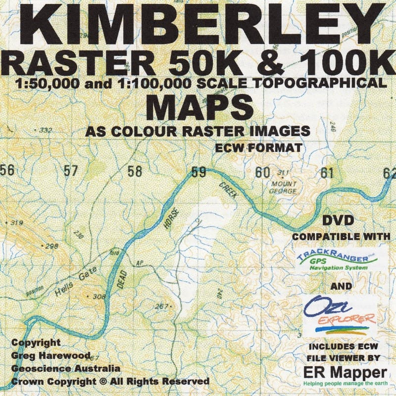
Kimberley 50K Topo USB - Greg Harewood
$99.00
or make 4 interest-free payments of
$24.75 AUD
fortnightly with
![]() More info
More info
High-Resolution Digital Mapping for 4WD, Exploration, and GIS Applications
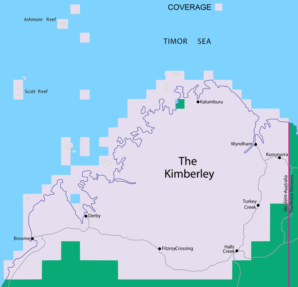
Explore one of Australia's last true wilderness frontiers with precision and confidence using this meticulously curated Kimberley 50K Topo Map USB by Greg Harewood—a must-have for off-road adventurers, remote-area travellers, cartographers, and GIS users.
This USB compilation includes a full suite of high-resolution topographic maps of the Kimberley region at 1:50,000 scale, backed by a selection of larger-scale mosaic maps that span the entire continent.
🧭 What’s Included on the USB
| Map Type | Format | Coverage |
|---|---|---|
| 438 x Topographic Sheets | OZF & ECW | Kimberley Region at 1:50,000 scale |
| 1 x Regional Mosaic | ECW | 1:100,000 Mosaic of the Kimberley |
| 1 x National Mosaic | ECW | 1:250,000 Mosaic – Covers all of Australia |
| Elevation Data | DEM (3-sec / 90m) | 3D terrain model for advanced applications |
| Calibration Files | Included | Ready for immediate use in GPS and GIS apps |
🛰️ Software Compatibility
The digital maps are pre-calibrated and fully compatible with:
-
Hema Navigator
-
VMS
-
Android Devices
-
OziExplorer
-
TrackRanger
-
GIS Mapping Software (ECW Support Required)
The inclusion of OZF and ECW formats ensures rapid loading, efficient storage, and compatibility across multiple devices and systems.
🌄 Technical Highlights
-
✅ Detailed 50K mapping of the Kimberley’s rugged terrain, remote tracks, watercourses, and elevation contours
-
✅ 3D Elevation Data (3-second DEM / 90-metre resolution) for route planning and terrain analysis
-
✅ High-fidelity ECW mosaics allow seamless viewing of entire regions
-
✅ Preloaded calibration files for instant georeferencing
-
✅ USB format – plug-and-play convenience for field use or desktop analysis
🏕️ Who It’s For
-
4WD enthusiasts heading into the Kimberley
-
Remote-area contractors and surveyors
-
Emergency services and logistical planners
-
Geologists, ecologists & environmental researchers
-
Anyone using OziExplorer, Hema Navigator, or professional GIS systems
Take your Kimberley expedition to the next level with unparalleled topographic accuracy.
Whether you’re planning a remote overland journey, researching country tracks, or integrating into professional GIS workflows, the Greg Harewood 50K Topo USB is your ultimate mapping companion.
Frequently Asked Questions
Where can I buy the Kimberley 50K Topo USB - Greg Harewood?
The Kimberley 50K Topo USB - Greg Harewood is available to buy online from Mapworld, Australia's largest map and geographic product retailer, with fast shipping Australia-wide.
Is the Kimberley 50K Topo USB - Greg Harewood in stock at Mapworld?
Mapworld maintains extensive stock across its map range and aims for fast dispatch. Orders placed before 2pm AEST on business days are typically dispatched the same day, with standard and express Australia-wide delivery options available.
What is Mapworld's returns policy?
Mapworld accepts returns on undamaged items in original condition. Contact Mapworld within 90 days of purchase to arrange a return or exchange.
Does Mapworld ship the Kimberley 50K Topo USB - Greg Harewood across Australia?
Yes, Mapworld ships Australia-wide. Standard shipping is a flat $7 rate, with free standard shipping on orders over $75. Express options are available at checkout. Most orders placed before 2pm AEST on weekdays are dispatched same day.
Related Items


© 2026 Mapworld. Website designed by Genie Media
X