- Australia ▾
- Topographic
▾
- Australia AUSTopo 250k (2025)
- Australia 50k Geoscience maps
- Australia 100k Geoscience maps
- Australia 250k Geoscience maps
- Australia 1:1m Geoscience maps
- New Zealand 50k maps
- New Zealand 250k maps
- New South Wales 25k maps
- New South Wales 50k maps
- New South Wales 100k maps
- Queensland 10k maps
- Queensland 25k maps
- Queensland 50k maps
- Queensland 100k maps
- Compasses
- Software
- GPS Systems
- Orienteering
- International ▾
- Wall Maps
▾
- World
- Australia & New Zealand
- Countries, Continents & Regions
- Historical
- Vintage National Geographic
- Australian Capital Territory
- New South Wales
- Northern Territory
- Queensland
- South Australia
- Tasmania
- Victoria
- Western Australia
- Celestial
- Children's
- Mining & Resources
- Wine Maps
- Healthcare
- Postcode Maps
- Electoral Maps
- Nautical ▾
- Flags
▾
- Australian Flag Sets & Banners
- Flag Bunting
- Handwavers
- Australian National Flags
- Aboriginal Flags
- Torres Strait Islander Flags
- International Flags
- Flagpoles & Accessories
- Australian Capital Territory Flags
- New South Wales Flags
- Northern Territory Flags
- Queensland Flags
- South Australia Flags
- Tasmania Flags
- Victoria Flags
- Western Australia Flags
- Gifts ▾
- Globes ▾
Dear valued customer. Please note that our checkout is not supported by old browsers. Please use a recent browser to access all checkout capabilities


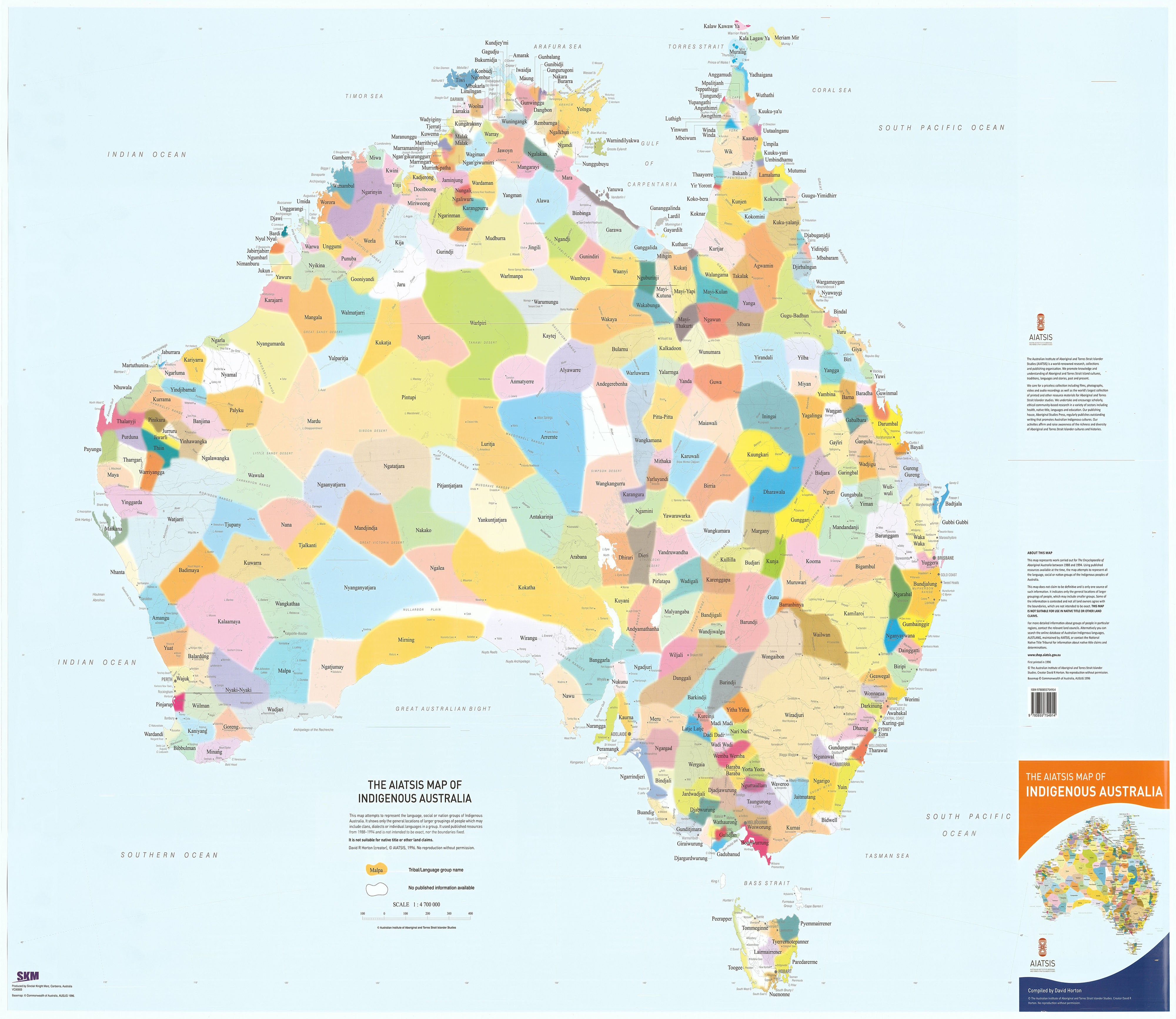

Indigenous Australia 1200 x 850mm Flat Laminated Wall Map AO Size
$64.95 $79.95
or make 4 interest-free payments of
$16.24 AUD
fortnightly with
![]() More info
More info
A powerful visual representation of Aboriginal and Torres Strait Islander languages, cultures, and connections to Country — designed to inform, educate, and inspire meaningful engagement with First Nations history and identity
The Indigenous Wall Map of Australia is a striking, large-format map that offers a compelling overview of the many diverse language and tribal groups that make up the cultural fabric of Aboriginal and Torres Strait Islander Australia. Developed using research from the groundbreaking Encyclopedia of Aboriginal Australia, this map is more than a geographical reference — it is a cultural map, a teaching tool, and a visual affirmation of the rich and complex histories that have shaped this continent for over 65,000 years.
At its core, the map seeks to provide an accessible and respectful entry point into understanding the breadth of Indigenous cultural landscapes. It acknowledges that Aboriginal and Torres Strait Islander peoples have maintained deep, spiritual, and practical relationships with the land for millennia, defined by distinct languages, customs, and kinship systems that vary widely from region to region.
🗺️ Map Overview and Cultural Context
-
The map divides Australia into 18 broadly defined cultural regions, each shaped by factors such as:
-
Shared language families
-
Spiritual and ceremonial practices
-
Trade networks and resource management
-
Seasonal mobility and land use
-
-
Within these regions, hundreds of language groups and tribal identities are mapped, giving a sense of the cultural richness and diversity that pre-dated colonisation — and continues today.
-
The map also includes the location of key historical and cultural sites, offering context to the regions shown. These include sacred places, important trade routes, missions, and early contact sites, providing both a geographical orientation and an invitation to deeper research.
-
Unlike political maps with fixed borders, this map acknowledges that boundaries are often fluid, and represent traditional understandings of Country, which may overlap or shift over time.
🎓 Educational and Interpretive Use
This map is especially valuable in educational settings and organisations seeking to promote cultural awareness and reconciliation. It is ideal for:
-
Schools and universities — as a visual teaching aid in subjects such as history, geography, Indigenous studies, and civics
-
Libraries and museums — for public education and community engagement
-
Government offices and workplaces — to support cultural safety and inclusion initiatives
-
Community centres and advocacy groups — to foster pride, understanding, and recognition of local Traditional Owners
-
Personal use — for those who want to explore or reconnect with the Indigenous heritage of the land they live on
Accompanying the map with classroom discussion or community-led workshops can further enhance its impact by grounding the content in local perspectives and lived experience.
🧾 Map Specifications
-
Size: 1200 mm wide x 850 mm high — a bold, full-colour wall map suitable for framing or direct wall mounting
-
Material: High-quality map stock, printed with vibrant, fade-resistant inks
-
Finish: Fully laminated with two sheets of 80-micron gloss laminate
-
Protects against tears, moisture, and UV damage
-
Allows the use of whiteboard markers and map dots for customisation
-
Perfect for interactive use in workshops or classrooms
-
🪃 Respectful Representation
The map reflects Indigenous ways of understanding land, community, and story. It avoids the imposition of rigid political borders and instead emphasises cultural connection and diversity. Importantly, it should be used with respect for the knowledge it represents and in consultation with local Traditional Owners wherever possible.
Please note: This map is not intended as an authoritative statement on legal or cultural boundaries. It is a representation, based on the best available research at the time of publication, and may differ from contemporary community-defined Country.
🌍 A Map With Purpose
This map is more than a visual display — it is a conversation starter, a reconciliation tool, and a testament to the resilience and continuity of the world’s oldest living cultures.
Hang it in your classroom, your office, your council chamber, your home — wherever you want to remind people that every part of this country has always been, and always will be, Aboriginal land.
Understand the land. Honour the knowledge. Share the story.
Frequently Asked Questions
What are the dimensions of the Indigenous Australia 1200 x 850mm Flat Laminated Wall Map AO Size?
Mapworld wall maps range from standard 700×1000mm to large-format 1000×1430mm Supermaps. The exact dimensions for this map are shown in the product title. Where multiple sizes are available, select your preferred size when adding to cart.
Is this wall map available laminated?
Many Mapworld wall maps are available in paper, laminated, or framed finishes. Check the product options when adding to cart. Laminated maps are wipe-clean and more durable.
Is this the latest edition?
Mapworld stocks the most current editions available from all publishers. Edition year is shown in the product title where applicable. Mapworld updates its catalogue as new editions are released.
Can I write on or pin this wall map?
Laminated wall maps can be written on with whiteboard markers and wiped clean. Paper maps can be pinned on a corkboard. Choose a laminated option for a writeable surface.
Does Mapworld ship the Indigenous Australia 1200 x 850mm Flat Laminated Wall Map AO Size across Australia?
Yes, Mapworld ships Australia-wide. Standard shipping is a flat $7 rate, with free standard shipping on orders over $75. Express options are available at checkout. Most orders placed before 2pm AEST on weekdays are dispatched same day.
Related Items


© 2026 Mapworld. Website designed by Genie Media
X