Your Essential Guide to Paris and Its Enchanting Surroundings
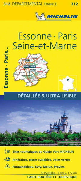
Experience the heart of France with Michelin Map 312, covering the vibrant capital and its scenic satellite regions—Essonne and Seine-et-Marne. Whether you're planning a cultural city break in Paris, a countryside escape to Fontainebleau, or a meandering road trip through the Île-de-France, this is the most detailed map of the region available. It's more than just a map—it's your passport to discovery.
Navigate with Confidence and Clarity
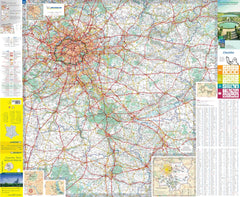
Crafted with Michelin’s trademark precision, this large-format local map offers unparalleled accuracy at a detailed scale of 1:150,000 (1 cm = 1.5 km). It’s designed to help you navigate both the grand boulevards of Paris and the narrowest lanes of rural Seine-et-Marne.
✅ Every Road, Every Village: Minor roads, backroads, and local tracks are clearly marked, making this the perfect tool for those looking to go beyond the typical tourist trail.
✅ Comprehensive Index: Quickly locate towns, suburbs, forests, landmarks, and regional attractions with ease.
✅ Distance Chart Included: Plan your itinerary with confidence, knowing how far each destination is from the next.
Ideal For:
✔ Urban Explorers & First-Time Visitors: Easily locate major Parisian landmarks, neighbourhoods, and access roads—ideal for anyone navigating the city and its surroundings by car.
✔ History Buffs & Architecture Enthusiasts: Use the map to trace routes to Château de Fontainebleau, medieval towns like Provins, and countless other historical gems nestled outside the capital.
✔ Families & Theme Park Goers: Heading to Disneyland Paris or Parc Astérix? This map ensures a smooth trip, with every route clearly marked from central Paris to regional attractions.
✔ Cyclists & Countryside Seekers: Escape the city into the regional parks, riversides, and forest trails of Seine-et-Marne and Essonne, with local routes and terrain relief helping you plan memorable outdoor adventures.
Product Specifications
| Feature | Details |
|---|---|
| Map Scale | 1:150,000 (1 cm = 1.5 km) |
| Sheet Size | 1200 mm x 1000 mm |
| Index | Full alphabetical list of towns and villages |
| Distance Chart | Included |
| Tourist Information | Michelin star-rated attractions and scenic routes |
| Edition | Latest available |
| Delivery Time | Ordered on demand – please allow 7–10 working days |
Michelin Quality You Can Trust
Michelin maps are a timeless favourite among travellers for their legibility, accuracy, and intuitive design. With over a century of cartographic excellence behind them, Michelin’s Local Map series continues to set the standard for travel maps in France and beyond.
Whether you’re exploring the City of Light or discovering a sleepy hamlet on the outskirts of Île-de-France, this map helps you see more, plan better, and explore deeper.
Crafted for Practical Travel
Printed on durable, high-quality paper and designed for repeated folding and reference, this map is built for real-world use—from the car dashboard to the hotel breakfast table. Whether you’re navigating urban expressways or plotting quiet countryside routes, Michelin Map 312 is your go-to travel companion.
Order your Michelin France Essonne / Paris / Seine-et-Marne Map 312 today and unlock the full potential of your journey through the historic, cultural, and natural wonders of central France. From world-famous landmarks to hidden villages, this map helps you find your way and find yourself.


