- Australia ▾
- Topographic
▾
- Australia AUSTopo 250k (2025)
- Australia 50k Geoscience maps
- Australia 100k Geoscience maps
- Australia 250k Geoscience maps
- Australia 1:1m Geoscience maps
- New Zealand 50k maps
- New Zealand 250k maps
- New South Wales 25k maps
- New South Wales 50k maps
- New South Wales 100k maps
- Queensland 10k maps
- Queensland 25k maps
- Queensland 50k maps
- Queensland 100k maps
- Western Australia 25k maps
- Western Australia 50k maps
- Western Australia 100k maps
- Compasses
- Software
- GPS Systems
- International ▾
- Wall Maps
▾
- World
- Australia & New Zealand
- Countries, Continents & Regions
- Historical
- Vintage National Geographic
- Australian Capital Territory
- New South Wales
- Northern Territory
- Queensland
- South Australia
- Tasmania
- Victoria
- Western Australia
- Celestial
- Children's
- Mining & Resources
- Wine Maps
- Healthcare
- Postcode Maps
- Electoral Maps
- Nautical ▾
- Flags
▾
- Australian Flag Sets & Banners
- Flag Bunting
- Handwavers
- Australian National Flags
- Aboriginal Flags
- Torres Strait Islander Flags
- International Flags
- Flagpoles & Accessories
- Australian Capital Territory Flags
- New South Wales Flags
- Northern Territory Flags
- Queensland Flags
- South Australia Flags
- Tasmania Flags
- Victoria Flags
- Western Australia Flags
- Gifts ▾
- Globes ▾
Dear valued customer. Please note that our checkout is not supported by old browsers. Please use a recent browser to access all checkout capabilities


Austria Hallwag Map
$25.95
Afterpay is only available for orders between $50.00 and $1000.00 More info
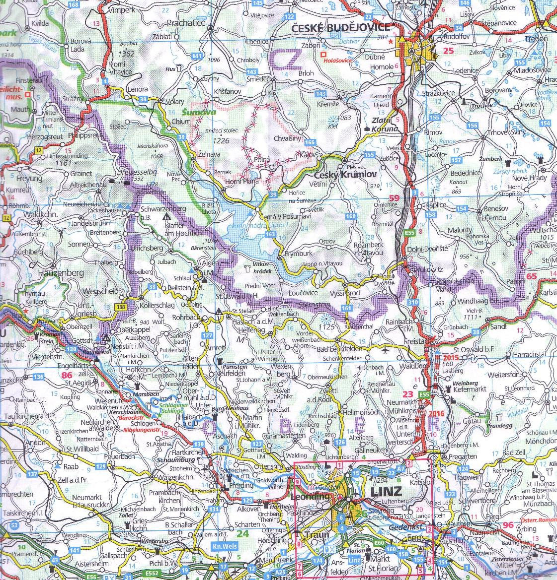
🇦🇹 Austria Road & Rail Map – Hallwag | 1:500,000
Explore Austria by Road or Rail with Precision and Clarity
🧭 The Ultimate Map for Travelling Through Austria
Whether you're driving the scenic Grossglockner High Alpine Road, boarding a train through the Tyrolean Alps, or planning a cultural getaway in Vienna, the Hallwag Austria Road & Rail Map is an indispensable companion for discovering Austria's rich landscapes and historic cities.
Beautifully designed and highly detailed, this map covers the entire country at a scale of 1:500,000, offering an excellent balance between detail and usability for both motorists and railway travellers.
🗺️ Key Features
-
Detailed Road & Rail Network – Includes motorways, federal roads, scenic routes, and complete rail coverage, making it perfect for multi-modal travel planning
-
Extensive Map Symbols & Legend – Features icons for:
-
Cable cars & mountain lifts
-
Ferry routes & ports
-
Airports
-
Castles (Schlösser)
-
Monuments, scenic lookouts & UNESCO sites
-
Rest areas, national parks, and more
-
-
Tourist-Friendly – Clearly marked points of interest, natural features, and regional highlights
🏙️ Bonus Booklet – Urban Detail Where You Need It
Included with the map is a fold-out booklet featuring enlarged city plans of:
-
Vienna
-
Salzburg
-
Innsbruck
-
Linz
-
Graz
These detailed insets are perfect for urban navigation, highlighting city streets, public transport routes, and cultural landmarks.
📐 Specifications
| Feature | Details |
|---|---|
| Title | Austria Road & Rail Map – Hallwag |
| Scale | 1:500,000 |
| Dimensions | 1000 mm (W) x 1250 mm (H) unfolded |
| Map Type | Folded map with booklet |
| Language | Multi-lingual legend (includes English) |
| Publisher | Hallwag Kümmerly+Frey |
🚗 Ideal For:
-
Self-driving holidays through Austria’s mountain passes and valleys
-
Railway enthusiasts seeking the best Alpine routes
-
Backpackers and tourers travelling between cities
-
Educational use for classrooms and geography students
-
Trip planners and travel agencies needing a single-sheet overview of Austria
🎒 Durable, detailed, and practical—this Hallwag Austria map makes route planning and on-the-go navigation a breeze. Whether you're crossing borders or venturing deep into alpine valleys, this is the map to take with you.
Frequently Asked Questions
Where can I buy the Austria Hallwag Map?
The Austria Hallwag Map is available to buy online from Mapworld, Australia's largest map and geographic product retailer, with fast shipping Australia-wide.
Is the Austria Hallwag Map in stock at Mapworld?
Mapworld maintains extensive stock across its map range and aims for fast dispatch. Orders placed before 2pm AEST on business days are typically dispatched the same day, with standard and express Australia-wide delivery options available.
What is Mapworld's returns policy?
Mapworld accepts returns on undamaged items in original condition. Contact Mapworld within 90 days of purchase to arrange a return or exchange.
Does Mapworld ship the Austria Hallwag Map across Australia?
Yes, Mapworld ships Australia-wide. Standard shipping is a flat $7 rate, with free standard shipping on orders over $75. Express options are available at checkout. Most orders placed before 2pm AEST on weekdays are dispatched same day.
Related Items


© 2026 Mapworld. Website designed by Genie Media
X