- Australia ▾
- Topographic
▾
- Australia AUSTopo 250k (2025)
- Australia 50k Geoscience maps
- Australia 100k Geoscience maps
- Australia 250k Geoscience maps
- Australia 1:1m Geoscience maps
- New Zealand 50k maps
- New Zealand 250k maps
- New South Wales 25k maps
- New South Wales 50k maps
- New South Wales 100k maps
- Queensland 10k maps
- Queensland 25k maps
- Queensland 50k maps
- Queensland 100k maps
- Western Australia 25k maps
- Western Australia 50k maps
- Western Australia 100k maps
- Compasses
- Software
- GPS Systems
- International ▾
- Wall Maps
▾
- World
- Australia & New Zealand
- Countries, Continents & Regions
- Historical
- Vintage National Geographic
- Australian Capital Territory
- New South Wales
- Northern Territory
- Queensland
- South Australia
- Tasmania
- Victoria
- Western Australia
- Celestial
- Children's
- Mining & Resources
- Wine Maps
- Healthcare
- Postcode Maps
- Electoral Maps
- Nautical ▾
- Flags
▾
- Australian Flag Sets & Banners
- Flag Bunting
- Handwavers
- Australian National Flags
- Aboriginal Flags
- Torres Strait Islander Flags
- International Flags
- Flagpoles & Accessories
- Australian Capital Territory Flags
- New South Wales Flags
- Northern Territory Flags
- Queensland Flags
- South Australia Flags
- Tasmania Flags
- Victoria Flags
- Western Australia Flags
- Gifts ▾
- Globes ▾
Dear valued customer. Please note that our checkout is not supported by old browsers. Please use a recent browser to access all checkout capabilities


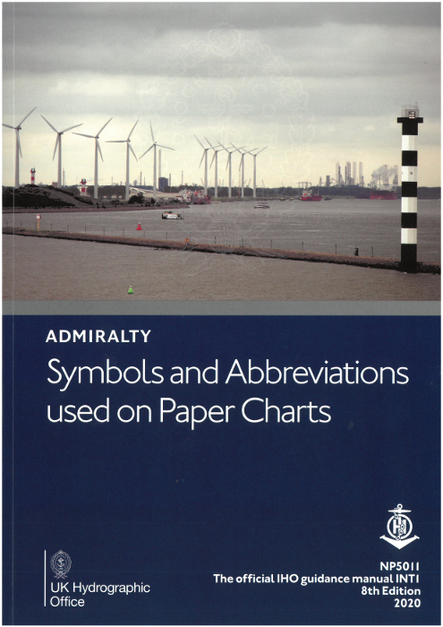
Admiralty Symbols & Abbreviations Chart Guide
$64.95
or make 4 interest-free payments of
$16.24 AUD
fortnightly with
![]() More info
More info
🧭 Admiralty Symbols & Abbreviations Chart Guide
Your Complete Companion to Navigating the World's Oceans
📘 A4 Full-Colour Booklet | Covers Admiralty & INT Chart Symbols | Ideal for Mariners, Instructors & Students
Set sail with confidence and clarity. The Admiralty Symbols & Abbreviations Chart Guide is a beautifully produced, full-colour A4 reference that unlocks the language of paper nautical charts. Whether you're plotting a course across a familiar coastline or exploring unfamiliar waters, this indispensable guide will keep your navigation sharp and your decisions informed.
Crafted by the UK Hydrographic Office and trusted by professional mariners worldwide, this guide is a comprehensive and up-to-date reference for interpreting Admiralty and INT chart symbology. It presents the complete set of hydrographic, topographic, and navigational symbols in a vibrant, easy-to-read layout—essential knowledge for offshore sailors, yachtmasters, cruising skippers, students, and maritime instructors.
🌊 What You’ll Discover Inside:
-
Hydrography & Seabed Features
Identify wrecks, rocks, sandbanks, depth contours, drying areas, soundings, submarine cables, and more. -
Topography & Coastal Landmarks
Decode shoreline features, cliffs, elevation lines, vegetation, buildings, bridges, and ports. -
Navigational Aids & Maritime Infrastructure
Comprehensive symbols for buoys, beacons, lights, radio signals, radar reflectors, AIS, anchorage zones, and restricted areas. -
Abbreviations & Terminology
Includes both English and international abbreviations, allowing you to interpret terms found on foreign charts and international INT charts with ease. -
Chart Interpretation Guidance
Learn how to read the layout of Admiralty charts, apply symbols in context, and integrate with pilot books and electronic navigation systems.
📌 Key Benefits:
| Feature | Description |
|---|---|
| 🌍 International Chart Coverage | Full coverage of both Admiralty and INT chart symbology |
| 🎨 Full-Colour Format | All symbols rendered in high-contrast colour for quick reference |
| 📐 Clear Structure | Organised into intuitive sections: Hydrography, Topography, Nav Aids |
| 📖 A4 Size | Convenient, durable format—perfect for the chart table or classroom |
| 🧭 Professional Relevance | Aligned with global navigation standards, ideal for certification prep |
| 🛟 Critical Safety Resource | Helps reduce navigational risk by eliminating misinterpretation |
🎓 Ideal For:
-
Maritime students and RYA Yachtmaster candidates
-
Sailing schools and instructors
-
Skippers, cruising sailors, and delivery crews
-
Commercial maritime operators and bridge officers
-
Emergency services, coastguards, and chart library users
-
Boaters transitioning from digital to traditional navigation
📦 Product Specifications:
| Attribute | Detail |
|---|---|
| Format | Paperback, A4 size |
| Pages | 40+ pages, full colour |
| Publisher | UK Hydrographic Office |
| Dimensions | 210 x 297 mm |
| Language | English with foreign abbreviations |
🧭 Why This Guide Belongs On Every Navigator’s Shelf:
-
Combines visual clarity with trusted Admiralty data
-
Ensures you're never guessing at critical chart information
-
Perfect onboard reference for planning, pilotage, and situational awareness
-
Compact and durable—fits neatly in chart tables, nav bags, and study kits
-
An essential companion to Admiralty NP5011, cruising guides, or digital nav tools
Whether you’re learning to navigate or leading the way, the Admiralty Symbols & Abbreviations Chart Guide ensures your understanding of paper charts is crystal clear, reliable, and always at your fingertips.
Navigate with knowledge. Sail with certainty.
Frequently Asked Questions
What area does the Admiralty Symbols & Abbreviations Chart Guide cover?
The Admiralty Symbols & Abbreviations Chart Guide covers the waterway or coastal area described in the product title. Chart coverage area and scale are printed on the chart face. DPI charts are produced at standard nautical chart scales appropriate for safe navigation of Australian coastal and inland waterways.
Is this the most current edition of this chart?
Mapworld stocks the most current editions available. Marine charts are updated regularly — always supplement with current Notices to Mariners.
Is this chart suitable for coastal navigation?
Marine charts are essential tools for coastal passage planning. Always use alongside a GPS chartplotter, current Notices to Mariners, and appropriate navigation training.
Does Mapworld ship the Admiralty Symbols & Abbreviations Chart Guide across Australia?
Yes, Mapworld ships Australia-wide. Standard shipping is a flat $7 rate, with free standard shipping on orders over $75. Express options are available at checkout. Most orders placed before 2pm AEST on weekdays are dispatched same day.
Related Items


© 2026 Mapworld. Website designed by Genie Media
X