- Australia ▾
- Topographic
▾
- Australia AUSTopo 250k (2024)
- Australia 50k Geoscience maps
- Australia 100k Geoscience maps
- Australia 250k Geoscience maps
- Australia 1.1m Geoscience maps
- New Zealand 50k maps
- New Zealand 250k maps
- New South Wales 25k maps
- New South Wales 50k maps
- New South Wales 100k maps
- Queensland 10k maps
- Queensland 25k maps
- Queensland 50k maps
- Queensland 100k maps
- Compasses
- Software
- GPS Systems
- Orienteering
- International ▾
- Wall Maps
▾
- World
- Australia & New Zealand
- Countries, Continents & Regions
- Historical
- Vintage National Geographic
- Australian Capital Territory
- New South Wales
- Northern Territory
- Queensland
- South Australia
- Tasmania
- Victoria
- Western Australia
- Celestial
- Children's
- Mining & Resources
- Wine Maps
- Healthcare
- Postcode Maps
- Electoral Maps
- Nautical ▾
- Flags
▾
- Australian Flag Sets & Banners
- Flag Bunting
- Handwavers
- Australian National Flags
- Aboriginal Flags
- Torres Strait Islander Flags
- International Flags
- Flagpoles & Accessories
- Australian Capital Territory Flags
- New South Wales Flags
- Northern Territory Flags
- Queensland Flags
- South Australia Flags
- Tasmania Flags
- Victoria Flags
- Western Australia Flags
- Gifts ▾
- Globes ▾
Dear valued customer. Please note that our checkout is not supported by old browsers. Please use a recent browser to access all checkout capabilities
Bormeester Wall Map of the World (1685) Print
$59.95
or make 4 interest-free payments of
$14.99 AUD
fortnightly with
![]() More info
More info
Bormeester — World Wall Map (1685)
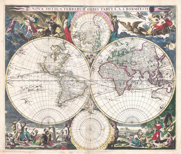
Two great circles hold the world; two polar eyes keep watch. This 1685 double-hemisphere by Dutch publisher Joachim (A. J.) Bormeester arranges oceans and continents with the clear confidence of the Low Countries’ golden age of mapmaking. East and West hemispheres span the page while North and South Pole diagrams complete the set—part science, part stagecraft—so you can watch the seventeenth-century world come into focus on your wall.
Why it captivates
-
Double-hemisphere elegance — East & West globes presented side by side for instant, room-length legibility.
-
Polar insight — dedicated North and South Pole projections above and below the main circles.
-
Dutch golden-age pedigree — a measured blend of accuracy, ornament and superb engraving from a leading Amsterdam tradition.
-
Scholarly & beautiful — fine graticules, calm lettering and a dignified cartouche read clearly from across the room.
What you’ll see
-
Two principal hemispheres with labelled meridians/parallels and disciplined coastline hatching.
-
Polar medallions (Arctic & Antarctic) completing the globe at a glance.
-
Continents, seas, major rivers and capes rendered in crisp seventeenth-century linework.
-
Title cartouche & neatline preserving the Latin original: Nova Totius Terrarum Orbis Tabula.
A richer historical frame
Printed in 1685, this sheet sits between Renaissance speculation and Enlightenment method. Bormeester’s workshop distilled travel accounts and state surveys into a world that feels ordered and legible—evidence arranged with care. The result is a map that balances navigational geometry with restrained theatricality, still compelling centuries on.
Choose your finish
Heavyweight Paper (160 gsm matte)
Best for: framing under glass in studies and living spaces
Look & feel: non-glare matte that preserves engraved linework and small labels
Laminated (true encapsulation)
Best for: classrooms, libraries, offices and shared spaces
Build: sealed edge-to-edge between two 80-micron gloss sheets
Benefit: wipe-clean, durable, moisture-resistant with UV-filtering gloss to help reduce fading
Laminated + Timber Hang Rails (Ready to hang)
What you get: encapsulated print plus natural lacquered timber rails top & bottom with a discreet hanging cord
Where it shines: foyers, lecture rooms, galleries—polished look with everyday toughness
Install: arrives ready to hang (just add a wall hook)
Lead time: please allow up to 10 working days for professional rail mounting
Archival Canvas (395 gsm HP Professional Matte)
Best for: premium interiors, boardrooms and curated displays
Print system: pigment-based, fade-resistant inks for long display life
Presence: textured surface adds warmth and museum-style depth
Canvas + Timber Hang Rails (Gallery-ready)
What you get: canvas fitted with natural timber rails top & bottom, matching cord
Where it shines: statement walls, heritage spaces, exhibition groupings
Install: ready to hang; single-hook friendly
Lead time: please allow up to 10 working days for rail mounting
Size (W × H)
-
841 × 714 mm — generous landscape format that honours the original proportions
At-a-glance materials
| Option | Best for | Key benefits |
|---|---|---|
| Paper (160 gsm) | Framing under glass | Matte clarity; crisp engraved detail |
| Laminated (encapsulated) | Busy/shared spaces | Wipeable; tough; UV-filtering gloss |
| Laminated + Rails | Ready-to-hang public display | Professional mount; easy install; durable |
| Canvas (395 gsm) | Premium display | Archival inks; textured depth; gallery appeal |
| Canvas + Rails | Gallery-ready feature | Period-true presentation; simple hanging |
Styling ideas
-
Salon wall: frame the paper edition; add a slim brass picture light for warm antique glow.
-
Exhibition trio: choose Laminated + Rails and flank with regional seventeenth-century plates.
-
Library or study: canvas with rails above timber cabinetry for quiet authority.
-
Travel nook: pair with a small caption card noting family ports or voyages.
Specifications
| Detail | Description |
|---|---|
| Title | Bormeester — World Map (Nova Totius Terrarum Orbis Tabula) |
| Edition | 1685 (decorative reproduction) |
| Cartographer/Publisher | Joachim (A. J.) Bormeester, Dutch |
| Projection | Double-hemisphere with polar insets |
| Language | Latin title and annotations |
| Type | Seventeenth-century engraved world map |
| Content Highlights | East & West hemispheres; North & South Pole medallions; graticule; coastal hatching; title cartouche |
| Finishes | Paper; Laminated (encapsulated); Laminated + Timber Rails; Canvas; Canvas + Timber Rails |
| Lead Time (Rails) | Up to 10 working days (laminated or canvas with rails) |
| Orientation | Landscape |
| Size | 841 × 714 mm (W × H) |
| Production | Made in Australia |
Who it’s for
-
Collectors & historians of seventeenth-century cartography
-
Educators, libraries & museums teaching projection history and global mapping
-
Interior designers seeking refined antique presence with scholarly depth
Claim your wall. Choose Paper for crisp, frame-ready clarity. Go Laminated + Timber Rails for tough, ready-to-hang polish. Step up to Archival Canvas + Timber Hang Rails for gallery weight. Printed in Australia with pigment-based, fade-resistant inks. Built to last. Hang it. Live with it. Keep the world in view.


