- Australia ▾
- Topographic
▾
- Australia AUSTopo 250k (2024)
- Australia 50k Geoscience maps
- Australia 100k Geoscience maps
- Australia 250k Geoscience maps
- Australia 1.1m Geoscience maps
- New Zealand 50k maps
- New Zealand 250k maps
- New South Wales 25k maps
- New South Wales 50k maps
- New South Wales 100k maps
- Queensland 10k maps
- Queensland 25k maps
- Queensland 50k maps
- Queensland 100k maps
- Compasses
- Software
- GPS Systems
- Orienteering
- International ▾
- Wall Maps
▾
- World
- Australia & New Zealand
- Countries, Continents & Regions
- Historical
- Vintage National Geographic
- Australian Capital Territory
- New South Wales
- Northern Territory
- Queensland
- South Australia
- Tasmania
- Victoria
- Western Australia
- Celestial
- Children's
- Mining & Resources
- Wine Maps
- Healthcare
- Postcode Maps
- Electoral Maps
- Nautical ▾
- Flags
▾
- Australian Flag Sets & Banners
- Flag Bunting
- Handwavers
- Australian National Flags
- Aboriginal Flags
- Torres Strait Islander Flags
- International Flags
- Flagpoles & Accessories
- Australian Capital Territory Flags
- New South Wales Flags
- Northern Territory Flags
- Queensland Flags
- South Australia Flags
- Tasmania Flags
- Victoria Flags
- Western Australia Flags
- Gifts ▾
- Globes ▾
Dear valued customer. Please note that our checkout is not supported by old browsers. Please use a recent browser to access all checkout capabilities
Perth & Western Australia Large QPA 710 x 1010mm Laminated Wall Map
$89.95
or make 4 interest-free payments of
$22.49 AUD
fortnightly with
![]() More info
More info
Double-Sided | Size: 1010 mm (H) × 710 mm (W)
Finish: Laminated for Durability & Write-On Use
Made in Australia
🌏 Two Maps in One – WA’s Big Picture & Perth’s Modern Metropolis
Whether you’re navigating the rugged vastness of Western Australia or planning your daily routes across Perth’s ever-expanding road network, this double-sided laminated wall map by QPA delivers exceptional clarity and practical detail.
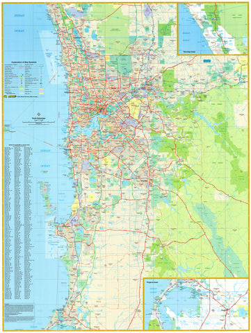
One side gives you the full sweep of Western Australia, from the Kimberley to the Great Australian Bight. Flip it over, and you’ll find a detailed metropolitan Perth map stretching from Yanchep in the north to Pinjarra in the south, including all the latest road infrastructure, such as the updated Perth Airport access network.
This map is a trusted resource for logistics planning, business routing, home offices, classrooms, or travel lovers wanting a comprehensive look at WA's capital and countryside—all in one convenient large-format print.
✨ Features You'll Love
🧭 Two Maps, Endless Uses
-
Side 1: Full Western Australia state map—ideal for big-picture planning
-
Side 2: Greater Perth metro area—up-to-date with new road systems, freeway extensions, and airport upgrades
🖊️ Laminated for Practical Use
-
Write on/wipe off surface—perfect for route planning with whiteboard markers or map dots
-
Encapsulated in gloss laminate to protect against wear, moisture, and UV light
📌 Detail-Rich & Up-To-Date
-
Major highways, regional towns, and remote road networks across WA
-
Clear postcode and suburb delineation across the Perth metro area
-
Shows localities, points of interest, and essential infrastructure
🪵 Versatile Display
-
Suitable for framing, pinning, or mounting
-
Ideal for use in homes, classrooms, real estate offices, transport hubs, or tour companies
📐 Product Specifications
| Feature | Detail |
|---|---|
| Title | Perth & Western Australia Large Wall Map |
| Publisher | QPA Maps |
| Format | Double-sided laminated map |
| Dimensions | 1010 mm (H) × 710 mm (W) |
| Finish | Gloss lamination, write-on/wipe-off surface |
| Made in | Australia |
🎯 Perfect For:
-
🏢 Businesses & Freight Operators: Track coverage areas and routes across Perth and WA
-
🧭 Travellers & 4WD Adventurers: Plan your next journey with a clear overview of terrain and access roads
-
🏡 Homes & Offices: A clean, stylish visual reference that invites exploration
-
🧑🏫 Educators & Students: A practical learning tool for Australian geography and infrastructure
-
📍 Real Estate & Urban Planners: Stay current with Perth’s suburban and arterial developments
🛒 A Must-Have for Every WA Wall
From the remote outback roads to the polished arterials of Perth, this map is a powerful tool that brings clarity, accuracy, and visual appeal to any wall. Whether you’re mapping your next adventure, coordinating operations, or just admiring the scale of this remarkable state—this is the map that does it all.
👉 Order now and get your laminated edition ready to display or use daily. Add map dots or hang with rails for the ultimate WA reference centrepiece.


