- Australia ▾
- Topographic
▾
- Australia AUSTopo 250k (2025)
- Australia 50k Geoscience maps
- Australia 100k Geoscience maps
- Australia 250k Geoscience maps
- Australia 1:1m Geoscience maps
- New Zealand 50k maps
- New Zealand 250k maps
- New South Wales 25k maps
- New South Wales 50k maps
- New South Wales 100k maps
- Queensland 10k maps
- Queensland 25k maps
- Queensland 50k maps
- Queensland 100k maps
- Compasses
- Software
- GPS Systems
- Orienteering
- International ▾
- Wall Maps
▾
- World
- Australia & New Zealand
- Countries, Continents & Regions
- Historical
- Vintage National Geographic
- Australian Capital Territory
- New South Wales
- Northern Territory
- Queensland
- South Australia
- Tasmania
- Victoria
- Western Australia
- Celestial
- Children's
- Mining & Resources
- Wine Maps
- Healthcare
- Postcode Maps
- Electoral Maps
- Nautical ▾
- Flags
▾
- Australian Flag Sets & Banners
- Flag Bunting
- Handwavers
- Australian National Flags
- Aboriginal Flags
- Torres Strait Islander Flags
- International Flags
- Flagpoles & Accessories
- Australian Capital Territory Flags
- New South Wales Flags
- Northern Territory Flags
- Queensland Flags
- South Australia Flags
- Tasmania Flags
- Victoria Flags
- Western Australia Flags
- Gifts ▾
- Globes ▾
Dear valued customer. Please note that our checkout is not supported by old browsers. Please use a recent browser to access all checkout capabilities


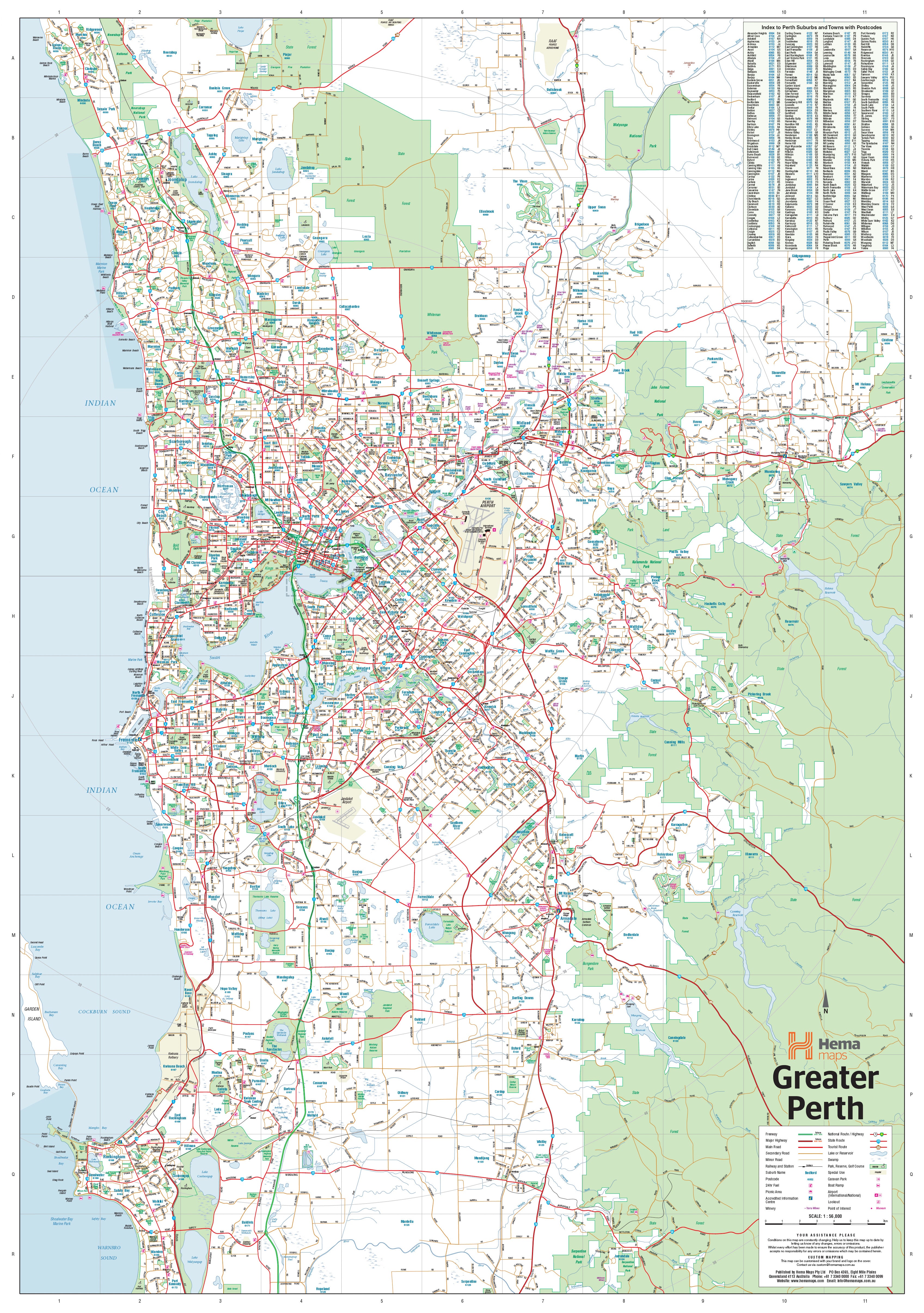

Perth & Region Hema 1000 x 1430mm Supermap Paper Wall Map
$129.95
or make 4 interest-free payments of
$32.49 AUD
fortnightly with
![]() More info
More info
Perth & Region — Hema Supermap (Paper Wall Map)
1000 × 1430 mm • Scale 1:70,000 • 170 gsm FSC® Matte-Coated Paper • Archival HP Pigment Inks • Made in Australia
A large-format, wall-readable overview of Greater Perth—ideal for planning, teaching, and daily reference. Hema’s authoritative cartography spans Quinns Rocks (north) to Safety Bay (south) and east to Mundaring, with road hierarchies and route numbering presented clearly for at-a-glance decisions.
🗺️ Coverage & Context
-
Metro footprint: Coast to Darling Scarp, capturing growth corridors and key activity centres.
-
Road network: Major & secondary roads with metro, national, and state route numbers.
-
Future awareness: Present & future freeways indicated for long-range planning.
-
Postcodes included: Perfect for sales territories, service regions, and demographic work.
🛣️ Built for Wall Readability
-
Calm palette, balanced line weights, crisp typography—clear from across the room.
-
Simple legend & scale keep meetings moving—no hunting for keys.
-
Label hierarchy reduces clutter while preserving critical detail.
🧭 Who Uses It (and How)
-
Business & ops: Depot catchments, delivery runs, service windows.
-
Sales teams: Postcode-based territory mapping and prospecting.
-
Education: Metropolitan geography, transport networks, urban structure.
-
Home & studio: Handsome, accurate reference that doubles as décor.
🌿 Materials & Print Quality
-
📄 Paper: 170 gsm FSC® matte-coated (low glare, sharp detail).
-
🎨 Inks: Archival HP pigment for rich colour and fade resistance.
-
🖼️ Framing-ready: Optimised for framing under glass to protect the print surface.
📐 Specifications
| Attribute | Details |
|---|---|
| Title | Perth & Region — Hema Supermap (Paper Wall Map) |
| Dimensions | 1000 mm (W) × 1430 mm (H) |
| Scale | 1:70,000 |
| Coverage | Quinns Rocks (N) to Safety Bay (S); west to the coast; east to Mundaring |
| Data Layers | Major & secondary roads; route numbers; present & future freeways; postcodes |
| Paper | 170 gsm FSC® matte-coated |
| Inks | Archival HP pigment (fade-resistant) |
| Finish | Paper (recommended framing under glass) |
| Origin | Made in Australia |
🤝 Our Commitment
-
Local craftsmanship: Designed, printed, and finished in Australia for consistent quality and responsive support.
-
Archival quality: Pigment inks and premium FSC® stocks chosen for long-lasting clarity.
-
Clarity first: Legends, symbols, and label hierarchies tuned for wall readability.
-
Sustainability: Paper sourced from FSC®-certified supply chains.
-
Packed with care: Each print is hand-checked and securely shipped to arrive clean, flat, and ready to frame.
Bring Greater Perth into sharp focus—professional, durable, and ready to frame.


