- Australia ▾
- Topographic
▾
- Australia AUSTopo 250k (2024)
- Australia 50k Geoscience maps
- Australia 100k Geoscience maps
- Australia 250k Geoscience maps
- Australia 1.1m Geoscience maps
- New Zealand 50k maps
- New Zealand 250k maps
- New South Wales 25k maps
- New South Wales 50k maps
- New South Wales 100k maps
- Queensland 10k maps
- Queensland 25k maps
- Queensland 50k maps
- Queensland 100k maps
- Compasses
- Software
- GPS Systems
- Orienteering
- International ▾
- Wall Maps
▾
- World
- Australia & New Zealand
- Countries, Continents & Regions
- Historical
- Vintage National Geographic
- Australian Capital Territory
- New South Wales
- Northern Territory
- Queensland
- South Australia
- Tasmania
- Victoria
- Western Australia
- Celestial
- Children's
- Mining & Resources
- Wine Maps
- Healthcare
- Postcode Maps
- Electoral Maps
- Nautical ▾
- Flags
▾
- Australian Flag Sets & Banners
- Flag Bunting
- Handwavers
- Australian National Flags
- Aboriginal Flags
- Torres Strait Islander Flags
- International Flags
- Flagpoles & Accessories
- Australian Capital Territory Flags
- New South Wales Flags
- Northern Territory Flags
- Queensland Flags
- South Australia Flags
- Tasmania Flags
- Victoria Flags
- Western Australia Flags
- Gifts ▾
- Globes ▾
Dear valued customer. Please note that our checkout is not supported by old browsers. Please use a recent browser to access all checkout capabilities


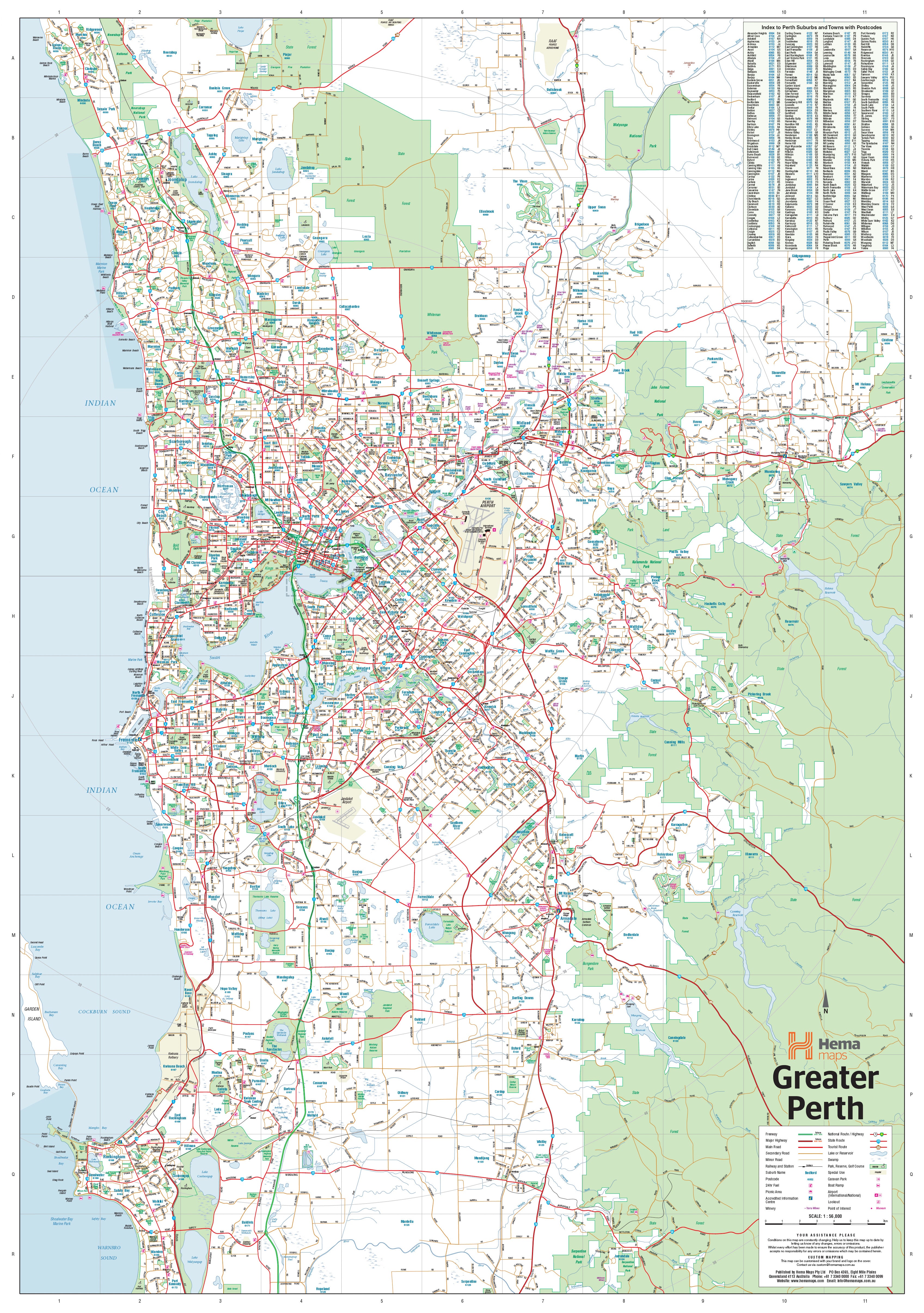

Perth & Region 700 x 1000mm Canvas Wall Map by Hema Maps
$199.00
or make 4 interest-free payments of
$49.75 AUD
fortnightly with
![]() More info
More info
700 × 1000 mm | Printed on Premium Canvas | Optional Timber Hang Rails
A striking cartographic celebration of Western Australia’s vibrant capital.
Step into the dynamic heart of Perth and its coastal surrounds with this beautifully rendered canvas wall map—a piece as practical as it is breathtaking. Whether you’re mapping out business deliveries, reminiscing on road trips, or simply dressing your wall with meaning, this map brings the city and its rhythms to life with clarity and artistry.
From the sun-drenched shores of Quinns Rocks in the north to the peaceful edges of Safety Bay in the south, and inland through the leafy hills of Mundaring, this map captures Perth’s full metropolitan reach. It’s more than a navigational tool—it's an invitation to discover, to connect, and to dream.
🌟 Why You'll Love It
-
🎨 A Work of Art With Purpose
Printed on 395 gsm HP Matte Canvas using premium pigment-based inks, this map radiates colour, contrast, and detail. It’s fade-resistant and gallery-grade—an heirloom-quality piece built to inspire for years to come. -
🛣️ A Complete Picture of Greater Perth
Meticulously detailed, the map includes major and minor roads, freeways (current and future), state and national route numbers, and postcode boundaries—perfect for logistics, planning, or curious minds. -
📌 Postcode Planning at a Glance
Every postcode zone is clearly defined—ideal for delivery route optimisation, marketing analysis, or simply getting to know the landscape of Perth like a local. -
🖼️ Elegant Wall Décor
A stunning feature for offices, studios, libraries, classrooms, or living spaces. Whether you're a local business, a Perth expat, or an admirer of the west coast, this map adds depth, story, and character to any wall. -
🌿 Made in Australia With Craftsmanship and Pride
Designed, printed, and assembled locally—supporting Australian cartography and print artisans.
Optional Timber Hang Rails
For a timeless and tidy display, choose the natural timber hang rail finish. The top and bottom rails add weight and balance to your map, while a matching hanging cord makes installation effortless—just one hook, and you're done.
📦 Please note: Canvas maps with hang rails are custom-assembled by our framer. Allow up to 10 working days for dispatch.
🧭 Map Coverage
-
Covers Perth’s urban footprint in full detail, from Quinns Rocks to Safety Bay, and Mundaring to the CBD
-
Highlights state and national roads, Met Roads, and planned freeway expansions
-
Includes suburbs, parks, transport corridors, and postcode zones
📐 Specifications
| Feature | Detail |
|---|---|
| Map Title | Perth & Region |
| Publisher | Hema Maps |
| Material | 395 gsm HP Professional Matte Canvas |
| Print Ink | Fade-resistant pigment-based inks |
| Size | 700 mm (W) × 1000 mm (H) |
| Scale | 1:80,000 |
| Finish Options | Canvas (standard), Canvas with Hang Rails |
| Made In | Australia |
🎯 Perfect For
-
Business Owners & Logistics Teams – Visualise delivery zones and travel corridors
-
Stylish Home Offices & Study Walls – A map that’s both decorative and informative
-
Teachers & Geography Enthusiasts – Showcase Perth’s unique layout and urban planning
-
Gift Buyers – A meaningful present for new homeowners, expats, or cartophiles
-
Real Estate Professionals – A clear visual reference for clients and consultations
More Than a Map—It’s a Connection to Place
Maps tell stories—of where we’ve been, where we are, and where we’re going. This Perth & Region Canvas Map by Hema isn’t just a tool—it’s a daily reminder of journeys past and possibilities ahead.
🎁 Order today and bring Perth’s spirit, structure, and sunlit sprawl into view. A gift for planners, dreamers, and proud Western Australians alike.


