- Australia ▾
- Topographic
▾
- Australia AUSTopo 250k (2024)
- Australia 50k Geoscience maps
- Australia 100k Geoscience maps
- Australia 250k Geoscience maps
- Australia 1.1m Geoscience maps
- New Zealand 50k maps
- New Zealand 250k maps
- New South Wales 25k maps
- New South Wales 50k maps
- New South Wales 100k maps
- Queensland 10k maps
- Queensland 25k maps
- Queensland 50k maps
- Queensland 100k maps
- Compasses
- Software
- GPS Systems
- Orienteering
- International ▾
- Wall Maps
▾
- World
- Australia & New Zealand
- Countries, Continents & Regions
- Historical
- Vintage National Geographic
- Australian Capital Territory
- New South Wales
- Northern Territory
- Queensland
- South Australia
- Tasmania
- Victoria
- Western Australia
- Celestial
- Children's
- Mining & Resources
- Wine Maps
- Healthcare
- Postcode Maps
- Electoral Maps
- Nautical ▾
- Flags
▾
- Australian Flag Sets & Banners
- Flag Bunting
- Handwavers
- Australian National Flags
- Aboriginal Flags
- Torres Strait Islander Flags
- International Flags
- Flagpoles & Accessories
- Australian Capital Territory Flags
- New South Wales Flags
- Northern Territory Flags
- Queensland Flags
- South Australia Flags
- Tasmania Flags
- Victoria Flags
- Western Australia Flags
- Gifts ▾
- Globes ▾
Dear valued customer. Please note that our checkout is not supported by old browsers. Please use a recent browser to access all checkout capabilities
Northern Territory UBD 571 Map 575 x 1000mm Laminated Wall Map with Hang Rails
$245.00
or make 4 interest-free payments of
$61.25 AUD
fortnightly with
![]() More info
More info
Explore the Vast, Iconic Top End with This Large-Format Planning & Reference Map
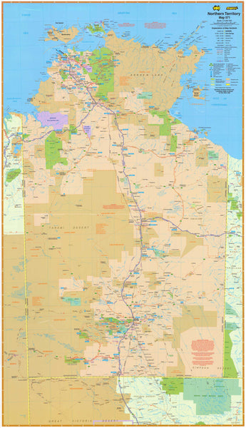
The Northern Territory State Map by UBD Gregory’s is a detailed, easy-to-read wall map that offers full coverage of the Territory at a scale of 1:2,000,000. Ideal for education, travel planning, logistics, business use, or simply showcasing the remote beauty of the Top End, this map is both informative and visually striking.
This large-format map includes a wide range of valuable cartographic features—from highway systems and town indexes to Aboriginal Land boundaries and national park overlays—making it one of the most comprehensive and useful maps of the NT available.
🌟 Map Highlights
| ✅ Feature | 📝 Description |
|---|---|
| 🗺️ Full State Coverage | Detailed mapping of the entire Northern Territory, including national highways, towns, distances, and road classifications |
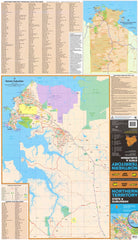
| 📍 Town & Suburb Index | Full town index for the Territory, plus Darwin suburban overview with postcode and suburb labels |
| 🛣️ Road Network | Includes major routes, national & state route numbers, and distances between key points |
| 🏞️ Aboriginal Lands & Parks | Reverse side includes shaded overlays of Aboriginal Land and national/marine parks |
| 🌆 Darwin Overview | Overview of Darwin’s layout for context; (for street-level detail, we recommend the Darwin UBD Map) |
🔧 Laminated & Ready to Hang
This edition comes professionally laminated and mounted with natural timber hang rails for a refined, ready-to-display finish:
-
✏️ Dry-erase surface – Mark routes, territories, or points of interest with whiteboard markers
-
📍 Map Dot compatible – Add planning pins or stickers without damaging the surface
-
💧 Durable lamination – Protects against water, UV fading, scuffs and tears
-
🪵 Timber hang rails – Top and bottom lacquered wooden battens with a cord for easy hanging
-
🧷 Perfect for use in offices, classrooms, government agencies, visitor centres, or home studies
📐 Specifications
| Specification | Details |
|---|---|
| Publisher | UBD Gregory’s |
| Map Name | Northern Territory State Map 571 |
| Scale | 1:2,000,000 (NT), 1:25,000 (Darwin inset) |
| Size | 590 mm (W) x 1000 mm (H) |
| Finish | Laminated with natural timber hang rails |
| Print Material | Printed on premium paper, encapsulated in 80-micron gloss laminate |
| Map Orientation | Vertical (portrait) |
| Made in | Australia |
🧭 Who Is This Map For?
| Ideal For | Why You’ll Love It |
|---|---|
| 🌏 Educators & Schools | Excellent for teaching Australian geography and Indigenous land awareness |
| 🚐 Travellers & Tourers | Plan road trips, remote travel routes, and NT exploration |
| 🏢 Offices & Planners | Use for regional planning, logistics, or client-facing displays |
| 🏠 Home Decor | A great feature map for anyone passionate about Australia’s vast north |
📦 Delivery Details
-
🎁 Rolled and shipped in a protective mailing tube
-
⏱️ Please allow up to 10 working days for delivery, as hang rails are custom-attached by our framing specialist
Bring the spirit and scale of the Northern Territory to your wall — from the red dirt roads of the Barkly Tableland to the wetlands of Kakadu, this map is a functional showpiece built for discovery, learning, and inspiration.


