- Australia ▾
- Topographic
▾
- Australia AUSTopo 250k (2024)
- Australia 50k Geoscience maps
- Australia 100k Geoscience maps
- Australia 250k Geoscience maps
- Australia 1.1m Geoscience maps
- New Zealand 50k maps
- New Zealand 250k maps
- New South Wales 25k maps
- New South Wales 50k maps
- New South Wales 100k maps
- Queensland 10k maps
- Queensland 25k maps
- Queensland 50k maps
- Queensland 100k maps
- Compasses
- Software
- GPS Systems
- Orienteering
- International ▾
- Wall Maps
▾
- World
- Australia & New Zealand
- Countries, Continents & Regions
- Historical
- Vintage National Geographic
- Australian Capital Territory
- New South Wales
- Northern Territory
- Queensland
- South Australia
- Tasmania
- Victoria
- Western Australia
- Celestial
- Children's
- Mining & Resources
- Wine Maps
- Healthcare
- Postcode Maps
- Electoral Maps
- Nautical ▾
- Flags
▾
- Australian Flag Sets & Banners
- Flag Bunting
- Handwavers
- Australian National Flags
- Aboriginal Flags
- Torres Strait Islander Flags
- International Flags
- Flagpoles & Accessories
- Australian Capital Territory Flags
- New South Wales Flags
- Northern Territory Flags
- Queensland Flags
- South Australia Flags
- Tasmania Flags
- Victoria Flags
- Western Australia Flags
- Gifts ▾
- Globes ▾
Dear valued customer. Please note that our checkout is not supported by old browsers. Please use a recent browser to access all checkout capabilities


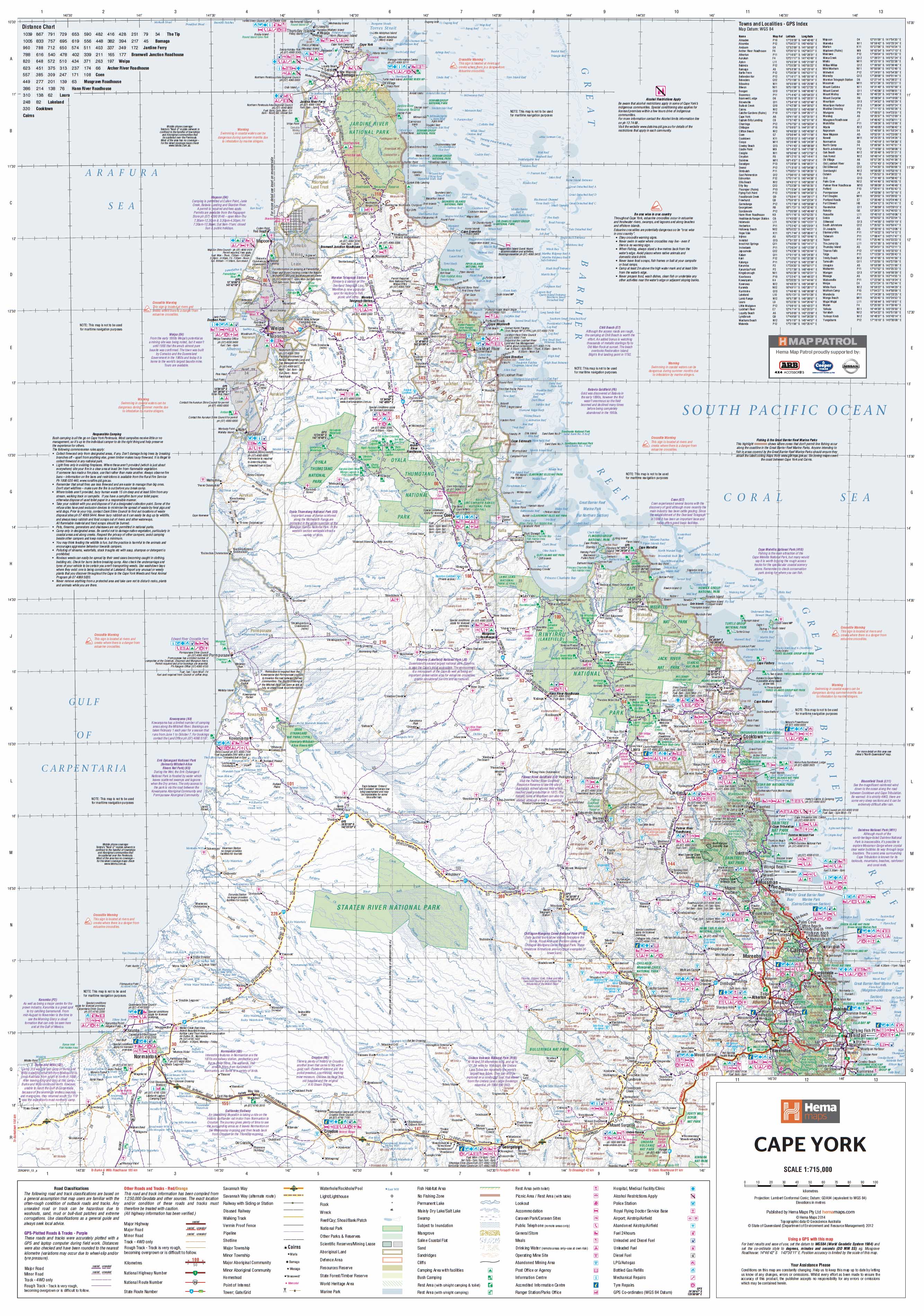
Cape York Hema 1000 x 1430mm Supermap Paper Wall Map
$129.95
or make 4 interest-free payments of
$32.49 AUD
fortnightly with
![]() More info
More info
Cape York — Hema Supermap (Paper Wall Map)
1000 × 1430 mm • Flat Paper Map • FSC 170 gsm • HP Archival Pigment Inks (Fade-Resistant)
Featuring one of Australia’s most iconic 4WD journeys—the Old Telegraph Track (OTT)—the Cape York Regional Supermap by Hema is built for explorers who want reliable detail at a glance. With a precise GPS grid & positions, a dedicated OTT inset, and clear wayfinding layers, it’s the perfect planning and display map for trips to the Tip.
🗝️ Key Features
-
GPS grid & positions for confident nav prep and waypoint planning
-
Old Telegraph Track inset highlighting creek crossings and the classic OTT route
-
Camping areas marked to plan overnight stops and staging points
-
National Parks & reserves shown for access, permits, and conservation awareness
-
New digital cartography for crisp, modern readability on large walls
📍 Coverage & Context
-
Cape York Peninsula from the Gulf to the Coral Sea, with key access routes to Bamaga/Seisia, Pajinka (the Tip), Weipa, Lockhart River, Cooktown, and more
-
Major 4WD corridors, service towns, and remote stretches called out for trip planning
-
Context for roadhouse locations and track junctions to help stage fuel/food stops
🧭 What’s Shown (At a Glance)
-
Road & track hierarchy: Main roads, secondary roads, 4WD tracks (clear symbology)
-
Navigation aids: GPS grid/positions, place names, distances (where provided)
-
Land & water: National Parks, reserves, notable rivers/creeks, coastal features
-
Trip essentials: Camping areas + Old Telegraph Track inset for route overview
🧩 How to Use It
-
Route sketching: Draft day-by-day legs using the OTT inset, then transfer to GPS
-
Waypoint planning: Use the grid to note key crossings, camps, fuel, and detours
-
Wall reference: Keep it visible in the shed, classroom, or trip room for team briefings
ℹ️ Travel note: Access and conditions in Cape York are seasonal and can change suddenly (wet season, creek levels, closures). Always check current local advice and road reports before you go.
🎨 Materials & Print Quality
-
Paper: Printed on FSC-certified 170 gsm matte-coated paper—smooth, glare-free, and ideal for framing under glass while preserving fine linework and subtle colour gradients.
-
Inks: Hewlett-Packard archival pigment-based inks deliver crisp detail and fade-resistant colour designed to last for years.
Prefer a wipe-clean or ready-to-hang finish? Ask about Laminated, Laminated + Timber Hang Rails, Canvas, or Canvas + Hang Rails versions in the same coverage and style.
📐 Size & Scale
-
Map size: 1000 × 1430 mm (portrait, Supermap)
-
Custom fit: Need 1000 × 1400 mm to suit an existing frame? We can accommodate on request.
🧼 Care & Framing Tips (Paper)
-
Use non-reflective (museum) glass to maintain the matte, low-glare look
-
Choose a slim, neutral frame to keep attention on the cartography
-
If matting, cut the window 2–3 mm undersize for a snug, professional fit
📊 Specifications
| Attribute | Details |
|---|---|
| Title | Cape York — Hema Supermap (Paper) |
| Focus | Cape York region with Old Telegraph Track inset |
| Layers | GPS grid & positions, camping areas, National Parks, updated digital cartography |
| Paper | FSC 170 gsm matte-coated |
| Inks | HP archival pigment-based inks (fade-resistant) |
| Format | Flat Paper Map (matte) |
| Size | 1000 × 1430 mm (portrait) |
🎯 Ideal For
-
4WD & overlanding crews planning an OTT run
-
Tour operators & visitor centres needing a clear wall reference
-
Schools & libraries teaching Australian geography and land management
-
Home & office décor for travellers and map lovers
🛒 Bring Cape York into focus—order the Hema Supermap (Paper) today, printed on FSC 170 gsm paper with HP archival pigments for crisp, long-lasting, fade-resistant colour.


