- Australia ▾
- Topographic
▾
- Australia AUSTopo 250k (2025)
- Australia 50k Geoscience maps
- Australia 100k Geoscience maps
- Australia 250k Geoscience maps
- Australia 1:1m Geoscience maps
- New Zealand 50k maps
- New Zealand 250k maps
- New South Wales 25k maps
- New South Wales 50k maps
- New South Wales 100k maps
- Queensland 10k maps
- Queensland 25k maps
- Queensland 50k maps
- Queensland 100k maps
- Compasses
- Software
- GPS Systems
- Orienteering
- International ▾
- Wall Maps
▾
- World
- Australia & New Zealand
- Countries, Continents & Regions
- Historical
- Vintage National Geographic
- Australian Capital Territory
- New South Wales
- Northern Territory
- Queensland
- South Australia
- Tasmania
- Victoria
- Western Australia
- Celestial
- Children's
- Mining & Resources
- Wine Maps
- Healthcare
- Postcode Maps
- Electoral Maps
- Nautical ▾
- Flags
▾
- Australian Flag Sets & Banners
- Flag Bunting
- Handwavers
- Australian National Flags
- Aboriginal Flags
- Torres Strait Islander Flags
- International Flags
- Flagpoles & Accessories
- Australian Capital Territory Flags
- New South Wales Flags
- Northern Territory Flags
- Queensland Flags
- South Australia Flags
- Tasmania Flags
- Victoria Flags
- Western Australia Flags
- Gifts ▾
- Globes ▾
Dear valued customer. Please note that our checkout is not supported by old browsers. Please use a recent browser to access all checkout capabilities


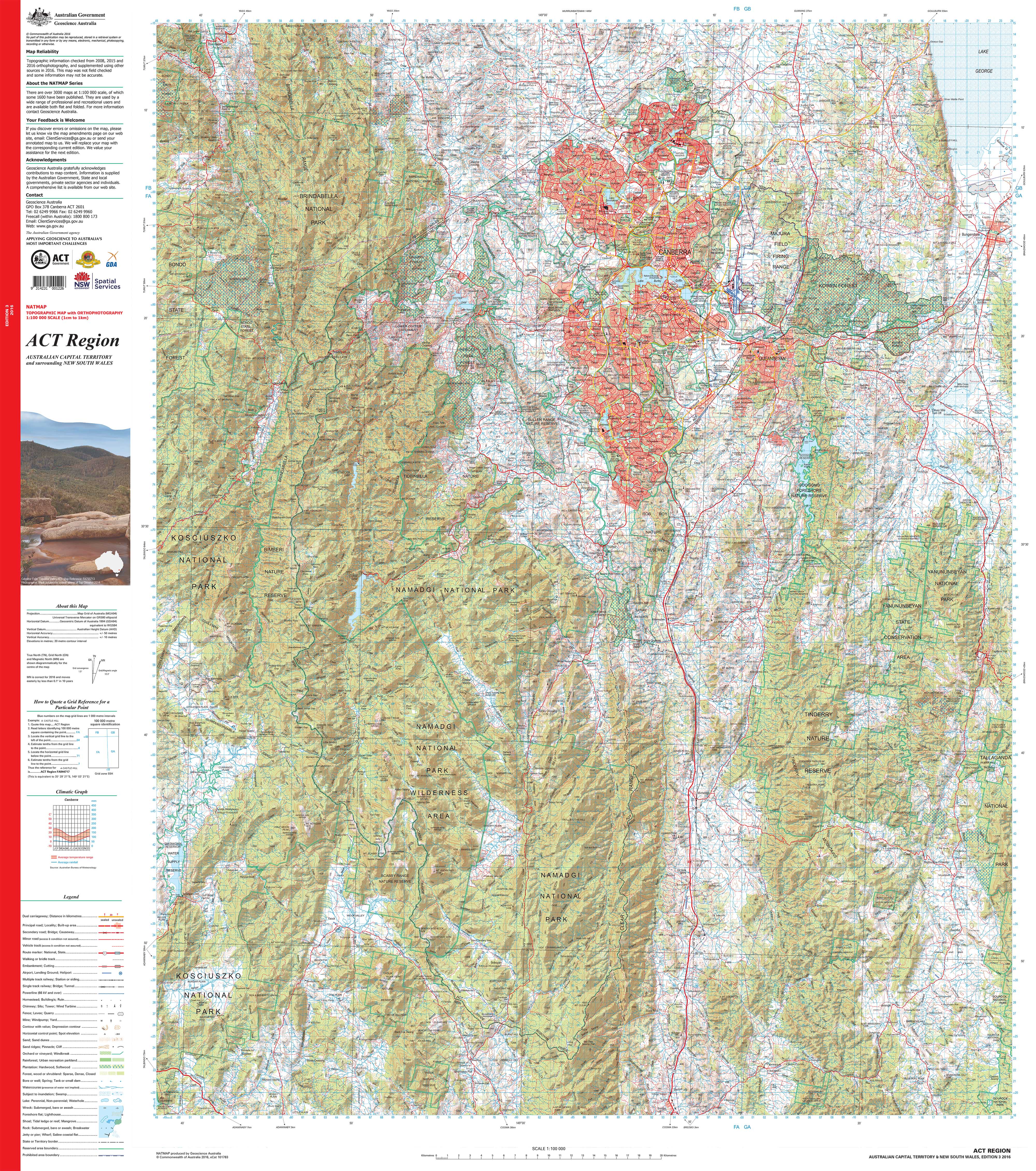
ACT Region Topographic 1:00k Wall Map
$69.95
or make 4 interest-free payments of
$17.49 AUD
fortnightly with
![]() More info
More info
ACT Region Topographic Wall Map — 1:100,000 Scale
Discover the Australian Capital Territory in striking clarity with this 1:100,000 topographic wall map — where 1 cm on the map equals 1 km on the ground. This professional-grade reference captures every contour, waterway, road, and landmark across the ACT, presenting the region in a way that is both practical and visually engaging.
Topographic maps remain one of the most trusted tools for understanding landscapes. This edition is no exception — used by 🚒 emergency services, 🌿 environmental managers, 🏗️ engineers, 🎓 educators, and outdoor enthusiasts alike. Whether you’re planning, teaching, exploring, or simply celebrating your connection to the Territory, this map is an invaluable and lasting resource.
Why it’s valued
-
Complete ACT coverage — Full regional detail at 1:100,000 scale.
-
Landscape clarity — Spot elevations, contour lines, rivers, creeks, and vegetation boundaries.
-
Human footprint — Roads, tracks, buildings, and administrative boundaries clearly marked.
-
Trusted reference — Used in emergency management, planning, engineering, and recreation.
-
Premium production — Printed on archival paper, laminated, or museum-grade canvas for a finish that lasts.
-
Australian made — Produced locally with pigment-based inks, colour-managed and hand-checked for accuracy.
Choose your finish
-
📄 Heavyweight Paper (160 gsm matte) — Archival quality; perfect for framing under glass in offices, classrooms, and homes.
-
💧 Laminated (True Encapsulation) — Encased in 2 × 80-micron gloss films; durable, wipe-clean, and built for everyday use.
-
🪵 Laminated + Timber Hang Rails — Lamination plus natural timber hang rails with top cord; ready to hang. Please allow up to 10 working days.
-
🎨 Archival Canvas (395 gsm HP Professional Matte) — Pigment-based, fade-resistant inks on museum-grade canvas for stunning clarity.
-
🪵 Canvas + Timber Hang Rails — Canvas finish with lacquered timber hang rails; a gallery-quality display. Please allow up to 10 working days.
Size (W × H)
-
920 mm × 1050 mm (36.2" × 41.3")
-
Orientation: Portrait
-
Aspect ratio: ~0.88 : 1
-
Framing tips: Mat windows should be cut 2–3 mm undersize for a snug fit; or float-mount with a ~3 mm reveal for a contemporary look.
-
Custom sizing: Available on request — contact us for tailored dimensions.
Specifications
| Attribute | Details |
|---|---|
| Title | ACT Region Topographic Wall Map |
| Scale | 1:100,000 (1 cm = 1 km) |
| Map Type | Topographic (Contours, hydrography, vegetation, boundaries, built features) |
| Print Size | 920 mm × 1050 mm |
| Available Finishes | Paper, Laminated, Laminated + Hang Rails, Canvas, Canvas + Hang Rails |
| Paper Weight | 160 gsm archival matte |
| Laminate | 2 × 80-micron gloss (true encapsulation) |
| Canvas Weight | 395 gsm HP Professional Matte |
| Inks | Pigment-based, fade-resistant |
| Optional Hang Rails | Natural timber, lacquered (allow up to 10 working days) |
| Origin | Printed in Australia |
Who it’s for
-
🚒 Emergency services & planners — Critical reference in operations and strategy.
-
🌿 Environmental & land managers — Track vegetation, waterways, and protected areas.
-
🏗️ Engineers & developers — Use accurate contours and features for infrastructure planning.
-
🎓 Educators & students — A teaching aid that makes geography real and tangible.
-
🥾 Outdoor enthusiasts — Hikers, campers, and locals who want to understand their landscape.
Our commitment
Every map is proudly 🇦🇺 printed in Australia using pigment-based, fade-resistant inks on premium materials. Each copy is colour-managed, hand-checked, and carefully packed to ensure it arrives in perfect condition.
🛒 Bring the ACT’s landscape into sharp relief with this professional-grade wall map — order today and enjoy a piece that’s as useful as it is beautiful.

