- Australia ▾
- Topographic
▾
- Australia AUSTopo 250k (2024)
- Australia 50k Geoscience maps
- Australia 100k Geoscience maps
- Australia 250k Geoscience maps
- Australia 1.1m Geoscience maps
- New Zealand 50k maps
- New Zealand 250k maps
- New South Wales 25k maps
- New South Wales 50k maps
- New South Wales 100k maps
- Queensland 10k maps
- Queensland 25k maps
- Queensland 50k maps
- Queensland 100k maps
- Compasses
- Software
- GPS Systems
- Orienteering
- International ▾
- Wall Maps
▾
- World
- Australia & New Zealand
- Countries, Continents & Regions
- Historical
- Vintage National Geographic
- Australian Capital Territory
- New South Wales
- Northern Territory
- Queensland
- South Australia
- Tasmania
- Victoria
- Western Australia
- Celestial
- Children's
- Mining & Resources
- Wine Maps
- Healthcare
- Postcode Maps
- Electoral Maps
- Nautical ▾
- Flags
▾
- Australian Flag Sets & Banners
- Flag Bunting
- Handwavers
- Australian National Flags
- Aboriginal Flags
- Torres Strait Islander Flags
- International Flags
- Flagpoles & Accessories
- Australian Capital Territory Flags
- New South Wales Flags
- Northern Territory Flags
- Queensland Flags
- South Australia Flags
- Tasmania Flags
- Victoria Flags
- Western Australia Flags
- Gifts ▾
- Globes ▾
Dear valued customer. Please note that our checkout is not supported by old browsers. Please use a recent browser to access all checkout capabilities


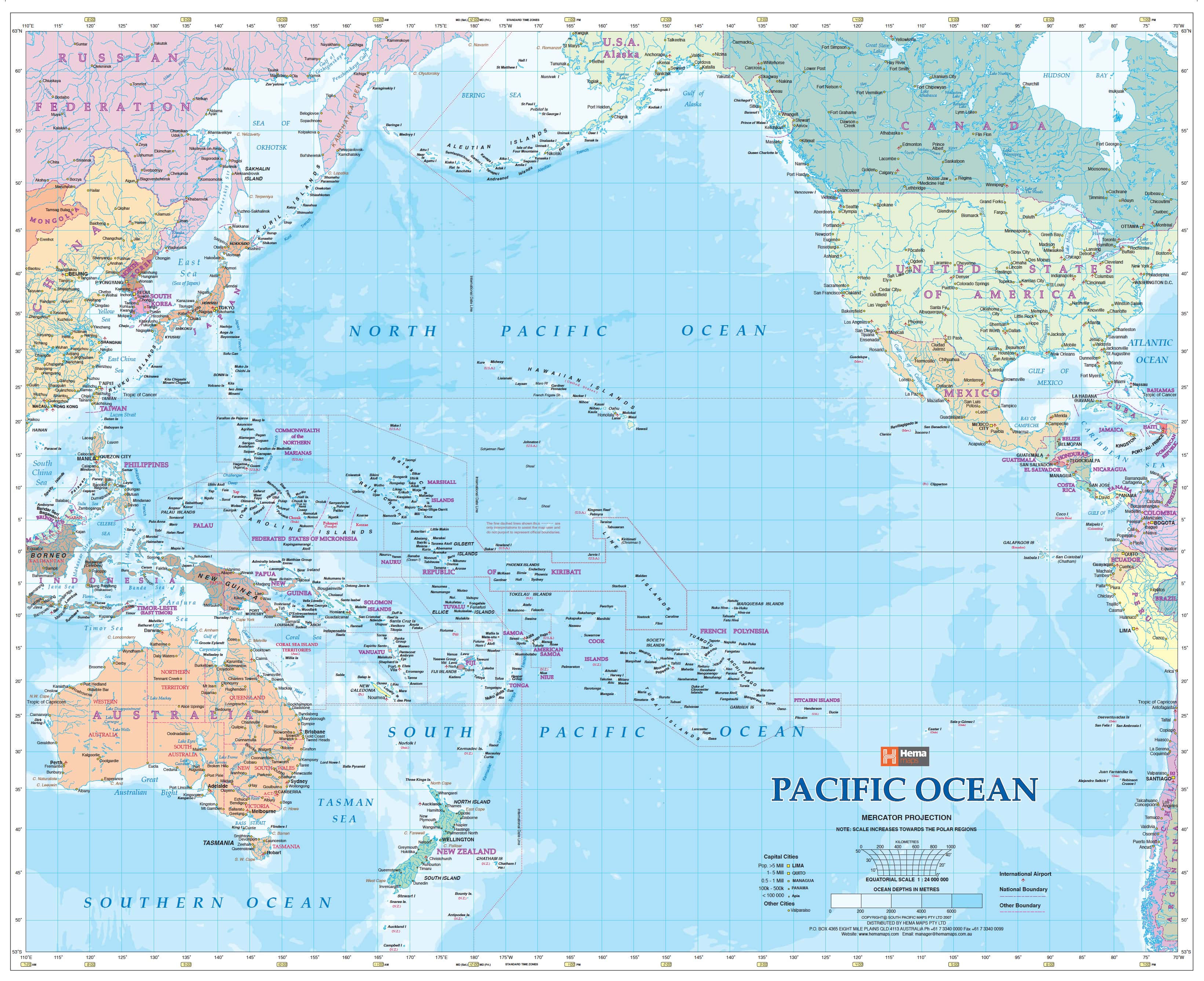
Pacific Ocean Hema 860 X 700mm Laminated Wall Map with Hang Rails
$249.95
or make 4 interest-free payments of
$62.49 AUD
fortnightly with
![]() More info
More info
Size: 860 mm (W) x 700 mm (H)
Scale: 1:24,000,000
Made in Australia
🌊 A Window onto the World’s Greatest Ocean
Covering over 63 million square miles, the Pacific Ocean is the largest and most powerful body of water on Earth—an expanse so vast it dwarfs all landmasses combined. With the Hema Pacific Ocean Wall Map, this scale and grandeur is brought into clear view. From the bustling shores of Australia and Japan in the west to the island-dotted expanses of Micronesia, Polynesia, and Melanesia, and onward to the Americas in the east, this map provides a panoramic snapshot of a region central to trade, exploration, and natural wonder.
Whether displayed in a classroom, business environment, or home study, the map captures both the enormity of the Pacific and the finer detail of its many islands, nations, and coastlines.
🗺 Cartographic Highlights
-
Comprehensive Coverage – From Australia, New Zealand, and Papua New Guinea across to Haiti and the western Americas.
-
Island Nations in Focus – Includes Fiji, Samoa, Tonga, Solomon Islands, Kiribati, French Polynesia, Vanuatu, and Guam, all marked with precision.
-
Political Borders & Capitals – Clear demarcation of countries and their capitals, ensuring easy reference.
-
Transport & Connectivity – Major sea routes, strategic island positions, and regional geography highlighted.
-
Readable Layout – Large format ensures text, coastlines, and national boundaries are visible even from a distance.
This isn’t just a reference tool—it’s an educational and decorative piece that helps contextualize the Pacific as the hub of international shipping, aviation, and cultural exchange.
✨ Premium Printing & Lamination
Every map is crafted with archival-grade quality to ensure lasting value:
-
Base Printing: Produced on 120 gsm premium matte coated paper, chosen for its smooth, non-reflective surface that enhances both colour and legibility.
-
Inks: Printed with Hewlett-Packard fade-resistant pigment inks for archival quality, ensuring vibrant colours that won’t fade over time.
-
Lamination: Encapsulated with 80-micron gloss laminate, providing a wipe-clean surface that is resistant to tears, stains, and moisture.
-
Interactive Use: The laminated surface allows you to use whiteboard markers or apply Mark-It Dots to track shipping routes, holidays, or educational projects—then wipe clean for reuse.
This combination of materials makes the map suitable for lifelong display in both professional and personal settings.
🪵 Timber Hang Rails: Functional Elegance
To transform this map from a reference tool into a display-worthy feature, it is professionally mounted with:
-
Solid natural timber hang rails at the top and bottom.
-
A lacquered finish that enhances the natural grain of the wood while protecting it for decades.
-
A sturdy hanging cord for easy installation—simply hang on a hook or nail and the map is ready to enjoy.
The addition of timber rails eliminates the need for framing, giving the map a heritage-inspired look that blends seamlessly into boardrooms, libraries, classrooms, or living spaces.
📦 Delivery & Craftsmanship
-
Each hang-railed map is individually mounted by our professional framer in Australia.
-
Please allow 10 working days for dispatch to ensure meticulous finishing.
-
Packaged securely for safe transport and delivery in pristine condition.
📐 Specifications
| Feature | Detail |
|---|---|
| Size | 860 mm (W) x 700 mm (H) |
| Scale | 1:24,000,000 |
| Paper Stock | 120 gsm matte coated paper |
| Ink Quality | Hewlett-Packard pigment inks, fade-resistant archival grade |
| Lamination | 80-micron gloss encapsulation (wipe-clean, durable) |
| Mounting | Solid natural timber hang rails with cord |
| Publisher | Hema Maps |
| Origin | Made in Australia |
🎯 Who Is This Map For?
-
Educators & Students – Bring lessons to life with a durable, interactive map.
-
Businesses & Logistics – Ideal for planning across shipping, aviation, or trade sectors.
-
Travel Enthusiasts – Trace flight paths, cruises, or personal adventures across the Pacific.
-
Collectors & Interiors – A statement piece for libraries, studies, or living rooms.
✨ The Pacific Ocean Laminated Map with Hang Rails is more than a wall map—it’s a piece of geography and history made tangible, combining Hema’s trusted cartography, archival print quality, and timber craftsmanship into a single enduring product.


