- Australia ▾
- Topographic
▾
- Australia AUSTopo 250k (2024)
- Australia 50k Geoscience maps
- Australia 100k Geoscience maps
- Australia 250k Geoscience maps
- Australia 1.1m Geoscience maps
- New Zealand 50k maps
- New Zealand 250k maps
- New South Wales 25k maps
- New South Wales 50k maps
- New South Wales 100k maps
- Queensland 10k maps
- Queensland 25k maps
- Queensland 50k maps
- Queensland 100k maps
- Compasses
- Software
- GPS Systems
- Orienteering
- International ▾
- Wall Maps
▾
- World
- Australia & New Zealand
- Countries, Continents & Regions
- Historical
- Vintage National Geographic
- Australian Capital Territory
- New South Wales
- Northern Territory
- Queensland
- South Australia
- Tasmania
- Victoria
- Western Australia
- Celestial
- Children's
- Mining & Resources
- Wine Maps
- Healthcare
- Postcode Maps
- Electoral Maps
- Nautical ▾
- Flags
▾
- Australian Flag Sets & Banners
- Flag Bunting
- Handwavers
- Australian National Flags
- Aboriginal Flags
- Torres Strait Islander Flags
- International Flags
- Flagpoles & Accessories
- Australian Capital Territory Flags
- New South Wales Flags
- Northern Territory Flags
- Queensland Flags
- South Australia Flags
- Tasmania Flags
- Victoria Flags
- Western Australia Flags
- Gifts ▾
- Globes ▾
Dear valued customer. Please note that our checkout is not supported by old browsers. Please use a recent browser to access all checkout capabilities
ONC CHARTS AUSTRALIA R-11
$69.95
or make 4 interest-free payments of
$17.49 AUD
fortnightly with
![]() More info
More info
ONC Chart – Australia R-11
Size: 1000 mm x 735 mm
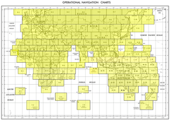
The ONC (Operational Navigation Chart) Australia R-11 delivers a large-format overview of the Australian continent, combining topographic accuracy with aeronautical references. At a scale of 1:1,000,000, it provides an ideal balance between detail and scope, making it an essential chart for educational, reference, and decorative purposes.
This edition covers the R-11 sector of Australia, including extensive detail on physical geography such as mountain ranges, coastlines, and deserts, as well as human-made infrastructure including towns, roads, railways, and pipelines. Designed originally for aeronautical reference, the ONC R-11 chart offers both scientific precision and visual clarity.
⚠ Important Note: This chart is NOT FOR NAVIGATIONAL USE. It is produced solely for educational, training, and decorative applications.
✈ Key Features
-
Topographic Detail – Depicts natural features such as rivers, deserts, mountains, and coastlines.
-
Aeronautical References – Includes aviation-related symbols and data, making it a useful study resource.
-
Infrastructure Mapping – Shows towns, villages, pipelines, railways, and key road networks.
-
Large-Format Coverage – Designed at a 1:1,000,000 scale for clarity and educational use.
-
Decorative & Functional – Equally at home in a classroom, aviation training centre, library, or office.
📐 Technical Specifications
| Feature | Detail |
|---|---|
| Title | ONC Chart – Australia R-11 |
| Coverage | Australia – R-11 sector |
| Scale | 1:1,000,000 |
| Content | Topography, aeronautical data, towns, villages, pipelines, roads, railways |
| Use | Educational, decorative, planning, aviation study |
| Warning | Not suitable for live navigation |
| Production | Printed in Australia |
🖼 Available Formats
This chart is available in five premium editions:
📜 Paper Edition (160 gsm Premium Paper)
-
Heavyweight 160 gsm matte-coated paper.
-
Ideal for framing under glass.
-
Affordable yet refined, perfect for classrooms, collectors, or offices.
✨ Laminated Edition (80 Micron Gloss Encapsulation)
-
Fully encapsulated between two sheets of 80-micron gloss laminate.
-
Durable, wipe-clean, and resistant to handling damage.
-
Suitable for whiteboard markers and map dots—perfect for planning.
🖌 Canvas Edition (395 gsm Matte Canvas)
-
Printed on archival-grade HP Professional Matte Canvas (395 gsm).
-
Pigment-based inks for fade resistance and long-term durability.
-
A gallery-quality piece that lasts for decades.
🪵 Laminated with Hang Rails (Natural Timber)
-
Combines laminated durability with handcrafted timber rails.
-
Professionally mounted and lacquered for a refined finish.
-
Includes a strong hanging cord for easy wall display.
🪵 Canvas with Hang Rails (Natural Timber)
-
The prestige edition: archival canvas presented with timber hang rails.
-
Professionally finished, creating a refined, natural display.
-
A statement décor piece for executive offices, libraries, or collectors.
Note: Please allow up to 10 working days for delivery of hang-railed editions, as each one is custom-mounted by our professional framer.
🌏 Why Choose the ONC Chart – Australia R-11?
The ONC R-11 chart is more than a reference tool—it is a visual statement of Australia’s geography and infrastructure.
-
For Educators & Students – Brings clarity to the study of Australia’s landforms, transport networks, and aeronautical data.
-
For Aviation Enthusiasts – While not suitable for live navigation, it mirrors the chart styles historically used in training and operations.
-
For Collectors – A distinctive chart with technical detail and aesthetic presence, ideal for framing or canvas display.
-
For Decorators & Designers – With canvas and rail-mounted options, this chart elevates interiors with a unique, technical aesthetic.
-
For Analysts & Planners – Provides an integrated perspective on natural features and infrastructure across the R-11 region.
The ONC Australia R-11 strikes the perfect balance between scientific precision and visual appeal, making it suitable for education, reference, and décor.


