- Australia ▾
- Topographic
▾
- Australia AUSTopo 250k (2024)
- Australia 50k Geoscience maps
- Australia 100k Geoscience maps
- Australia 250k Geoscience maps
- Australia 1.1m Geoscience maps
- New Zealand 50k maps
- New Zealand 250k maps
- New South Wales 25k maps
- New South Wales 50k maps
- New South Wales 100k maps
- Queensland 10k maps
- Queensland 25k maps
- Queensland 50k maps
- Queensland 100k maps
- Compasses
- Software
- GPS Systems
- Orienteering
- International ▾
- Wall Maps
▾
- World
- Australia & New Zealand
- Countries, Continents & Regions
- Historical
- Vintage National Geographic
- Australian Capital Territory
- New South Wales
- Northern Territory
- Queensland
- South Australia
- Tasmania
- Victoria
- Western Australia
- Celestial
- Children's
- Mining & Resources
- Wine Maps
- Healthcare
- Postcode Maps
- Electoral Maps
- Nautical ▾
- Flags
▾
- Australian Flag Sets & Banners
- Flag Bunting
- Handwavers
- Australian National Flags
- Aboriginal Flags
- Torres Strait Islander Flags
- International Flags
- Flagpoles & Accessories
- Australian Capital Territory Flags
- New South Wales Flags
- Northern Territory Flags
- Queensland Flags
- South Australia Flags
- Tasmania Flags
- Victoria Flags
- Western Australia Flags
- Gifts ▾
- Globes ▾
Dear valued customer. Please note that our checkout is not supported by old browsers. Please use a recent browser to access all checkout capabilities
ONC CHARTS AUSTRALIA Q-13
$69.95
or make 4 interest-free payments of
$17.49 AUD
fortnightly with
![]() More info
More info
ONC Chart – Australia Q-13
Size: 1000 mm x 735 mm
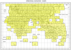
The ONC (Operational Navigation Chart) Australia Q-13 presents a large-scale 1:1,000,000 view of the Q-13 sector of Australia. Originally designed for aviation purposes, this chart combines topographic precision with aeronautical references, offering a layered view of both the natural landscape and human infrastructure.
Rich in detail, the Q-13 chart highlights terrain features such as rivers, mountain ranges, deserts, and coastlines, alongside cultural data including towns, villages, pipelines, roads, and railways. Each element has been carefully designed to provide clarity and accuracy, making this chart not only an important teaching and reference tool, but also a collector’s piece for those with an interest in aviation history and cartography.
⚠ Important Notice: Supplied strictly NOT FOR NAVIGATIONAL USE. Intended for educational, decorative, and planning purposes only.
✈ Key Features
-
Topographic Coverage – Includes physical landforms such as rivers, deserts, ranges, and coasts.
-
Aviation Heritage – Reflects the ONC tradition of aeronautical cartography.
-
Cultural & Infrastructure Data – Shows towns, villages, pipelines, railways, and roads.
-
Readable Scale – 1:1,000,000 for clarity while maintaining broad coverage.
-
Multi-Use Design – Perfect for education, training, office display, or historical collections.
📐 Technical Specifications
| Feature | Detail |
|---|---|
| Title | ONC Chart – Australia Q-13 |
| Coverage | Australia – Q-13 sector |
| Scale | 1:1,000,000 |
| Content | Topography, aeronautical references, towns, villages, pipelines, railways, roads |
| Use | Educational, decorative, planning, reference |
| Warning | Not for navigational use |
| Production | Printed in Australia |
🖼 Available Formats
This chart is available in five premium editions, tailored to different uses and environments:
📜 Paper Edition (160 gsm Premium Paper)
-
Printed on heavyweight 160 gsm matte-coated paper.
-
Ideal for framing under glass in a classic display.
-
Accessible and refined—perfect for educational or collector use.
✨ Laminated Edition (80 Micron Gloss Encapsulation)
-
Fully encapsulated in 80-micron gloss laminate.
-
Wipe-clean, tear-resistant, and durable.
-
Practical for classrooms, offices, and training environments—compatible with map dots and whiteboard markers.
🖌 Canvas Edition (395 gsm Matte Canvas)
-
Produced on 395 gsm HP Professional Matte Canvas with pigment-based inks.
-
Fade-resistant, richly textured, and gallery-quality.
-
Designed to endure for decades as both décor and reference.
🪵 Laminated with Hang Rails (Natural Timber)
-
Combines laminated resilience with display-ready practicality.
-
Fitted with lacquered timber rails (top and bottom) and a sturdy hanging cord.
-
Suitable for professional, academic, or planning settings.
🪵 Canvas with Hang Rails (Natural Timber)
-
The premium collector’s edition: archival canvas mounted with handcrafted timber rails.
-
Rails are lacquered to a smooth, natural finish.
-
A prestige décor statement for executive offices, libraries, or aviation enthusiasts.
Note: Please allow up to 10 working days for delivery of hang-railed editions, as each one is custom-mounted by our framer.
🌏 Why Choose the ONC Chart – Australia Q-13?
The Q-13 chart captures more than geography—it represents a piece of aviation cartographic history, reimagined for modern collectors, educators, and professionals. It is:
-
A visual teaching aid for classrooms and training.
-
A heritage reference for aviation and cartography enthusiasts.
-
A statement décor piece for offices, libraries, and homes.
-
A functional overview tool for planners and analysts.
By uniting scientific accuracy with aesthetic presentation, the ONC Q-13 is equally suited as a functional wall map and a collector’s showcase edition.


