- Australia ▾
- Topographic
▾
- Australia AUSTopo 250k (2024)
- Australia 50k Geoscience maps
- Australia 100k Geoscience maps
- Australia 250k Geoscience maps
- Australia 1.1m Geoscience maps
- New Zealand 50k maps
- New Zealand 250k maps
- New South Wales 25k maps
- New South Wales 50k maps
- New South Wales 100k maps
- Queensland 10k maps
- Queensland 25k maps
- Queensland 50k maps
- Queensland 100k maps
- Compasses
- Software
- GPS Systems
- Orienteering
- International ▾
- Wall Maps
▾
- World
- Australia & New Zealand
- Countries, Continents & Regions
- Historical
- Vintage National Geographic
- Australian Capital Territory
- New South Wales
- Northern Territory
- Queensland
- South Australia
- Tasmania
- Victoria
- Western Australia
- Celestial
- Children's
- Mining & Resources
- Wine Maps
- Healthcare
- Postcode Maps
- Electoral Maps
- Nautical ▾
- Flags
▾
- Australian Flag Sets & Banners
- Flag Bunting
- Handwavers
- Australian National Flags
- Aboriginal Flags
- Torres Strait Islander Flags
- International Flags
- Flagpoles & Accessories
- Australian Capital Territory Flags
- New South Wales Flags
- Northern Territory Flags
- Queensland Flags
- South Australia Flags
- Tasmania Flags
- Victoria Flags
- Western Australia Flags
- Gifts ▾
- Globes ▾
Dear valued customer. Please note that our checkout is not supported by old browsers. Please use a recent browser to access all checkout capabilities
ONC CHARTS AUSTRALIA N-10
$69.95
or make 4 interest-free payments of
$17.49 AUD
fortnightly with
![]() More info
More info
ONC Chart – Australia N-10
Size: 1000 mm x 735 mm
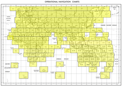
The ONC (Operational Navigation Chart) Australia N-10 is part of the international ONC series, created for aviation mapping at a 1:1,000,000 scale. This chart covers its designated northern Australian sector, combining detailed topographic features with aeronautical data to provide a unique perspective of the landscape.
Mountains, rivers, coastlines, and deserts are clearly depicted, alongside human-made features such as towns, villages, pipelines, roads, and railways. Designed for clarity and authority, the N-10 chart functions as both a historical cartographic resource and a decorative wall map, making it highly versatile for collectors, educators, and geography enthusiasts.
⚠ Important Notice: This chart is supplied strictly NOT FOR NAVIGATIONAL USE. It is intended only for educational, reference, and display purposes.
✈ Key Features
-
Part of the ONC Series – Produced for international aviation reference.
-
Detailed Coverage – Clearly identifies topography and infrastructure in its sector.
-
Balanced Scale – 1:1,000,000 scale allows broad coverage with practical levels of detail.
-
Infrastructure Highlighted – Towns, villages, railways, roads, and pipelines included.
-
Multipurpose Use – Ideal for reference, teaching, collecting, or wall display.
📐 Technical Specifications
| Feature | Detail |
|---|---|
| Title | ONC Chart – Australia N-10 |
| Coverage | Northern Australia (Sector N-10) |
| Scale | 1:1,000,000 |
| Content | Topography, aeronautical data, towns, villages, pipelines, railways, roads |
| Use | Educational, reference, decorative |
| Warning | Not for navigational use |
| Production | Printed in Australia |
🖼 Available Formats
This chart is available in five premium editions, tailored to a variety of uses:
📜 Paper Edition (160 gsm Premium Paper)
-
Printed on heavyweight 160 gsm paper.
-
Perfect for framing under glass for a clean archival look.
-
Accessible and elegant, ideal for collectors and study.
✨ Laminated Edition (80 Micron Gloss Encapsulation)
-
True encapsulation between two 80-micron gloss laminate sheets.
-
Wipe-clean, durable, and resistant to tears and stains.
-
Suitable for offices, classrooms, or planning.
🖌 Canvas Edition (395 gsm Matte Canvas)
-
Printed on archival-grade 395 gsm HP Professional Matte Canvas.
-
Uses pigment-based inks for fade resistance and lasting clarity.
-
Richly textured finish for a gallery-quality display.
🪵 Laminated with Hang Rails (Natural Timber)
-
Combines laminated protection with ready-to-hang presentation.
-
Professionally mounted with natural timber rails, lacquered for durability.
-
Includes a strong cord for effortless hanging.
🪵 Canvas with Hang Rails (Natural Timber)
-
Premium edition: archival canvas mounted with handcrafted timber rails.
-
Lacquered natural finish for a refined appearance.
-
A prestige décor piece, perfect for libraries, executive offices, or collectors.
Note: Please allow up to 10 working days for hang-railed editions, as each is custom-mounted by our framer.
🌏 Why Choose the ONC Chart – Australia N-10?
The Australia N-10 ONC Chart is more than a map—it is a fusion of geography, aviation, and design. With its precision detail, historical significance, and decorative appeal, it is ideal for:
-
Educators – A classroom-ready tool for geography and aviation history.
-
Collectors – A valuable addition to any set of ONC charts.
-
Researchers – Useful for studying Australia’s landscapes and infrastructure.
-
Interior Display – Striking when presented on canvas or with timber hang rails.
When paired with adjoining charts, the N-10 sheet fits seamlessly into the broader ONC Australia series, offering expanded regional coverage.


