- Australia ▾
- Topographic
▾
- Australia AUSTopo 250k (2025)
- Australia 50k Geoscience maps
- Australia 100k Geoscience maps
- Australia 250k Geoscience maps
- Australia 1:1m Geoscience maps
- New Zealand 50k maps
- New Zealand 250k maps
- New South Wales 25k maps
- New South Wales 50k maps
- New South Wales 100k maps
- Queensland 10k maps
- Queensland 25k maps
- Queensland 50k maps
- Queensland 100k maps
- Compasses
- Software
- GPS Systems
- Orienteering
- International ▾
- Wall Maps
▾
- World
- Australia & New Zealand
- Countries, Continents & Regions
- Historical
- Vintage National Geographic
- Australian Capital Territory
- New South Wales
- Northern Territory
- Queensland
- South Australia
- Tasmania
- Victoria
- Western Australia
- Celestial
- Children's
- Mining & Resources
- Wine Maps
- Healthcare
- Postcode Maps
- Electoral Maps
- Nautical ▾
- Flags
▾
- Australian Flag Sets & Banners
- Flag Bunting
- Handwavers
- Australian National Flags
- Aboriginal Flags
- Torres Strait Islander Flags
- International Flags
- Flagpoles & Accessories
- Australian Capital Territory Flags
- New South Wales Flags
- Northern Territory Flags
- Queensland Flags
- South Australia Flags
- Tasmania Flags
- Victoria Flags
- Western Australia Flags
- Gifts ▾
- Globes ▾
Dear valued customer. Please note that our checkout is not supported by old browsers. Please use a recent browser to access all checkout capabilities
Australia 149 Gregory's Supermap 1480 x 1020mm Laminated Wall Map
$199.95
or make 4 interest-free payments of
$49.99 AUD
fortnightly with
![]() More info
More info
The Ultimate Large-Format Reference Map of Australia
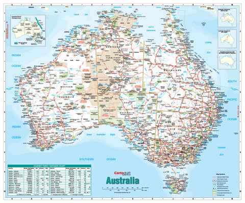
Step into the vast landscapes, vibrant cities, and remote wilderness of Australia with the Gregory’s Supermap—a large-format, fully indexed, and meticulously detailed wall map that captures the entire continent in a single, clear view. Measuring an impressive 1480 × 1020 mm, this premium laminated map combines cartographic accuracy with everyday practicality, making it the perfect choice for schools, offices, government departments, tourism operators, and passionate travellers.
🌏 A Map That Covers It All
This Gregory’s Supermap delivers a complete geographic and infrastructure overview of Australia, including:
-
Major & Minor Cities, Towns, and Homesteads – From capital cities to the smallest rural settlements.
-
Full Road Network – Clear distinctions between dual carriageways, through routes, major and minor roads, and sealed/unsealed tracks, ensuring navigational accuracy.
-
Railway Lines – Passenger and freight lines mapped for complete transport context.
-
Protected & Cultural Lands – National parks, reserves, state parks, and Aboriginal lands clearly shaded for easy identification.
-
Tourist Points of Interest – Attractions and natural wonders highlighted in distinctive blue text, unique to Gregory’s maps.
-
Comprehensive Place Name Index – Quickly locate towns, landmarks, and geographic features with ease.
💎 Built for Everyday Use – Premium Lamination
The Gregory’s Supermap is printed on high-grade paper and then encapsulated using 100-micron gloss laminate with true encapsulation—completely sealing the map between two layers of protective film. This premium finish means your map is:
-
Write-On/Wipe-Off Friendly – Perfect for classroom or office use with whiteboard markers.
-
Durable & Long-Lasting – Tear-resistant and stain-proof, ideal for frequent handling.
-
UV-Resistant – Protects against fading, keeping colours vibrant for years.
-
Travel-Planning Ready – Use map dots or markers to plan routes, track journeys, or record visited destinations.
📐 Specifications
| Feature | Detail |
|---|---|
| Publisher | Gregory’s |
| Map Type | Australia Reference – Large Format |
| Size | 1480 mm (W) × 1020 mm (H) |
| Material | High-quality paper with 100-micron gloss laminate (true encapsulation) |
| Scale | Large format for detailed reference |
| Index | Fully indexed place names |
| Lamination | Write-on/wipe-off, UV-protected |
| Made in | Australia |
🎯 Who This Map is For
📚 Education & Schools – Perfect for teaching Australian geography in a visual, engaging way.
🏢 Corporate & Government Use – For planning, analysis, and presentation.
🗺 Travellers & 4WD Enthusiasts – Plan routes, explore remote tracks, and record adventures.
🏡 Home Reference – Ideal for a study, library, or home office.
🚚 Delivery Information
This map is supplied fully laminated and ready to display. As it is a large-format map, it is shipped rolled in a secure postal tube to ensure it arrives in pristine condition.


