- Australia ▾
- Topographic
▾
- Australia AUSTopo 250k (2025)
- Australia 50k Geoscience maps
- Australia 100k Geoscience maps
- Australia 250k Geoscience maps
- Australia 1:1m Geoscience maps
- New Zealand 50k maps
- New Zealand 250k maps
- New South Wales 25k maps
- New South Wales 50k maps
- New South Wales 100k maps
- Queensland 10k maps
- Queensland 25k maps
- Queensland 50k maps
- Queensland 100k maps
- Western Australia 25k maps
- Western Australia 50k maps
- Western Australia 100k maps
- Compasses
- Software
- GPS Systems
- International ▾
- Wall Maps
▾
- World
- Australia & New Zealand
- Countries, Continents & Regions
- Historical
- Vintage National Geographic
- Australian Capital Territory
- New South Wales
- Northern Territory
- Queensland
- South Australia
- Tasmania
- Victoria
- Western Australia
- Celestial
- Children's
- Mining & Resources
- Wine Maps
- Healthcare
- Postcode Maps
- Electoral Maps
- Nautical ▾
- Flags
▾
- Australian Flag Sets & Banners
- Flag Bunting
- Handwavers
- Australian National Flags
- Aboriginal Flags
- Torres Strait Islander Flags
- International Flags
- Flagpoles & Accessories
- Australian Capital Territory Flags
- New South Wales Flags
- Northern Territory Flags
- Queensland Flags
- South Australia Flags
- Tasmania Flags
- Victoria Flags
- Western Australia Flags
- Gifts ▾
- Globes ▾
Dear valued customer. Please note that our checkout is not supported by old browsers. Please use a recent browser to access all checkout capabilities


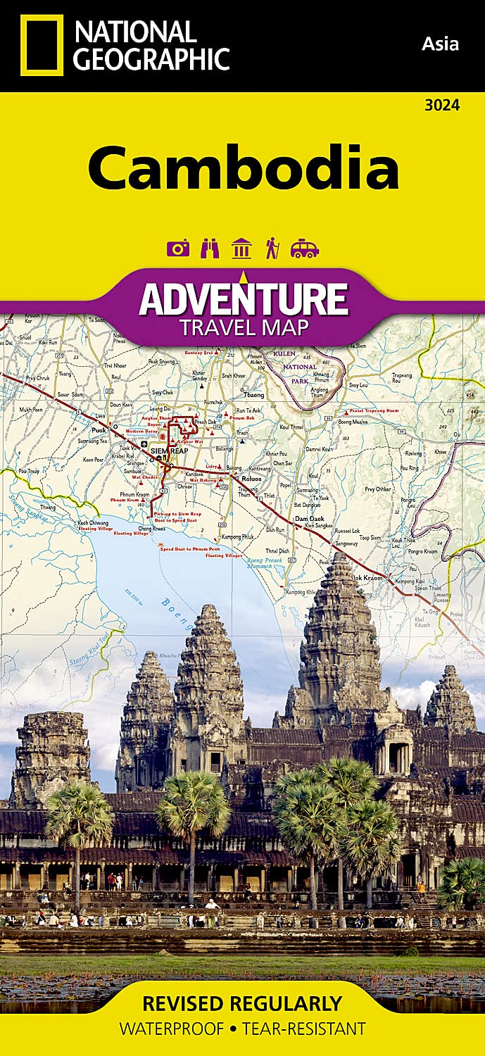
Cambodia National Geographic Folded Map
$27.95
Afterpay is only available for orders between $50.00 and $1000.00 More info
Scale: 1:525,000
Flat Sheet Size: 25.5" x 37.75"
Folded Size: 4.25" x 9.25"
Format: Waterproof & Tear-Resistant Synthetic Paper
Publisher: National Geographic Maps
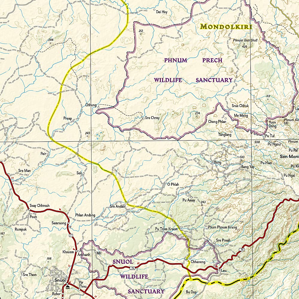
🇰🇭 Discover Cambodia Beyond the Guidebooks
National Geographic’s Cambodia Adventure Map is expertly designed for travellers seeking cultural depth, geographic accuracy, and off-the-beaten-path experiences. Whether you’re trekking through temple ruins, navigating riverside towns, or exploring remote jungle roads, this map provides the practical information and nuanced detail you need to explore Cambodia confidently and thoroughly.
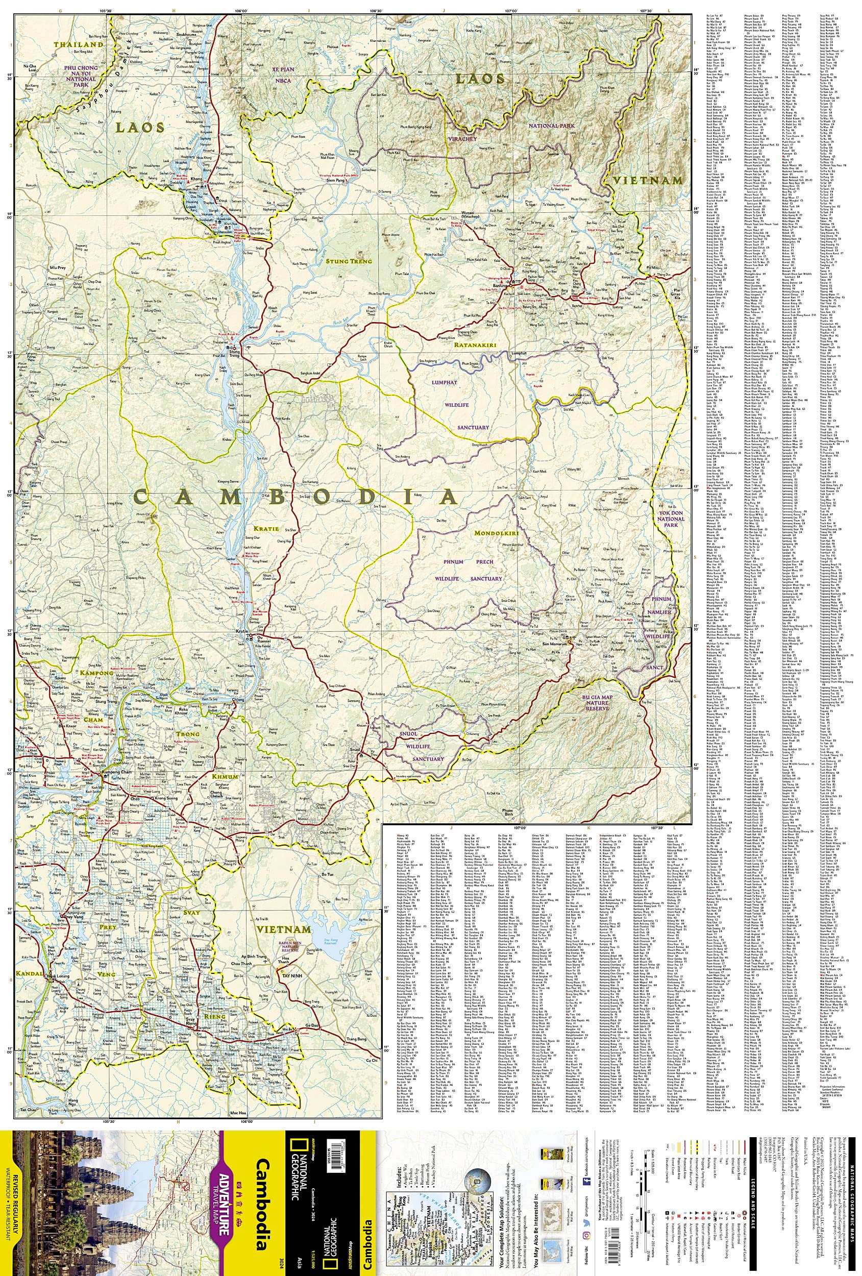
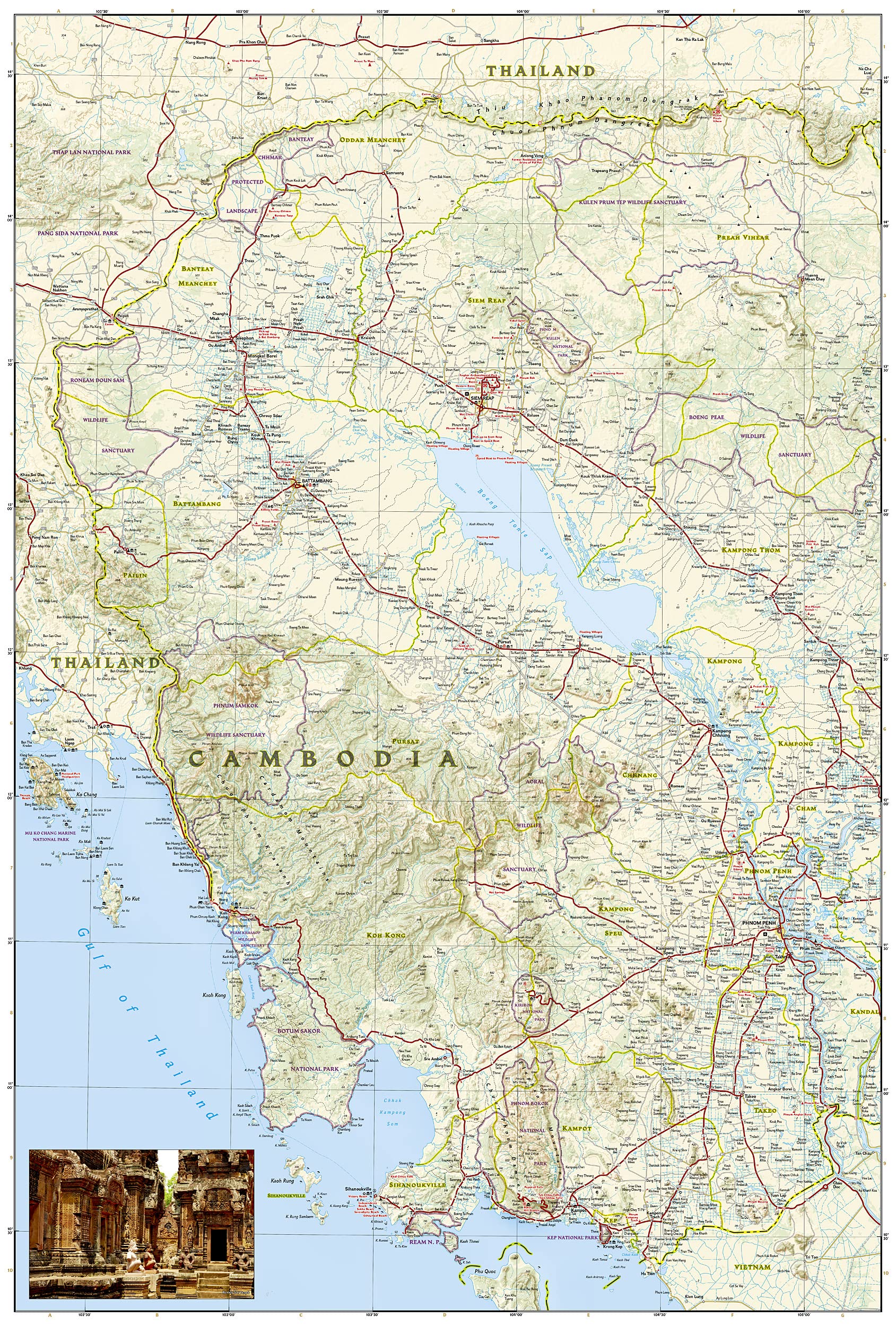
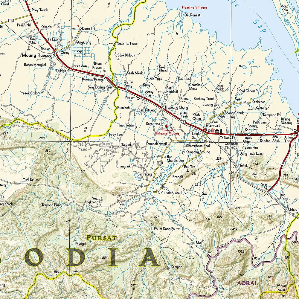
🔍 Map Coverage & Features
-
Cities & Towns: Full national coverage, from small villages to major urban hubs like Phnom Penh, Siem Reap, and Sihanoukville
-
Road Networks: Primary highways, regional routes, and lesser-travelled roads, all clearly marked with distances and classifications
-
Topography & Waterways: Includes rivers, mountain ranges, and Cambodia’s defining feature—Tonle Sap Lake
-
Borders & Neighbours: Highlights Cambodia’s border regions with Vietnam, Laos, and Thailand, making cross-border planning easy
-
Inset Focus Areas:
-
Phnom Penh and its surrounds
-
Angkor Wat and Angkor Thom in Siem Reap
-
Coastline along the Gulf of Thailand
-
The Mekong River corridor
-
🏞️ What Makes This an Adventure Map?
Unlike a basic road atlas, National Geographic Adventure Maps are enriched with:
-
✅ Cultural landmarks – including pagodas, ruins, temples, and war memorials
-
✅ Historical sites – such as Angkor Wat, Angkor Thom, and French colonial architecture
-
✅ Natural attractions – beaches, lakes, national parks, and wildlife reserves
-
✅ Ecotourism sites – bird sanctuaries, trekking areas, waterfalls, and forested plateaus
-
✅ Recreational symbols – hiking trails, scenic routes, ferries, and more
💪 Built for Real Travel
Crafted for rugged journeys and unpredictable weather, this map is printed on durable synthetic paper that’s:
-
✔ Waterproof
-
✔ Tear-resistant
-
✔ Weatherproof & fold-friendly
Ideal for slipping into a daypack, using on tuk-tuk rides, or spreading out in the jungle without fear of damage.
📌 Why Choose This Map?
| ✔ Feature | 🎯 Benefit |
|---|---|
| Expert cartography by National Geographic | Trusted accuracy and visual clarity |
| Full country coverage with cross-border detail | Ideal for multi-country Southeast Asia travel |
| Specialty points of interest | Cultural, recreational, and ecological destinations |
| Lightweight and field-durable | Built for hands-on use in all weather |
| Folds small but packs big | Large format when open, pocket size when closed |
🌏 Who Is This Map For?
-
Adventure travellers seeking both tourist hotspots and hidden gems
-
History buffs tracing the remnants of the Angkor Empire
-
Ecotourists & birdwatchers exploring Tonle Sap or Ream National Park
-
Cultural explorers visiting villages, temples, or floating markets
-
Cross-border cyclists or backpackers navigating into Vietnam or Laos
-
Travel agents & tour operators needing a versatile reference tool
✅ Summary
From the legendary temples of Angkor to the quiet white-sand beaches along the Gulf of Thailand, the Cambodia National Geographic Adventure Map is a reliable, rugged, and beautifully detailed tool for exploring one of Southeast Asia’s most captivating destinations.
Frequently Asked Questions
What area does the Cambodia National Geographic Folded Map cover?
The Cambodia National Geographic Folded Map provides road coverage of the region named in the product title. The map covers major cities, highways, towns, and regional roads, with inset city maps for key urban centres where applicable.
Is the Cambodia National Geographic Folded Map up to date?
Yes, this is the current edition. Mapworld stocks the most current editions from all major publishers, updated to reflect new roads and infrastructure.
What size is this map when unfolded?
Folded maps from Mapworld's range are compact and portable. Most standard folded road or travel maps open to between A1 (594 × 841mm) and A0 (841 × 1189mm) when fully unfolded, and fold down to approximately A4 or smaller for easy storage in a glove box, bag, or backpack.
Is the Cambodia National Geographic Folded Map in stock at Mapworld?
Mapworld maintains extensive stock across its map range and aims for fast dispatch. Orders placed before 2pm AEST on business days are typically dispatched the same day, with standard and express Australia-wide delivery options available.
Does Mapworld ship the Cambodia National Geographic Folded Map across Australia?
Yes, Mapworld ships Australia-wide. Standard shipping is a flat $7 rate, with free standard shipping on orders over $75. Express options are available at checkout. Most orders placed before 2pm AEST on weekdays are dispatched same day.
Related Items

© 2026 Mapworld. Website designed by Genie Media
X