- Australia ▾
- Topographic
▾
- Australia AUSTopo 250k (2024)
- Australia 50k Geoscience maps
- Australia 100k Geoscience maps
- Australia 250k Geoscience maps
- Australia 1.1m Geoscience maps
- New Zealand 50k maps
- New Zealand 250k maps
- New South Wales 25k maps
- New South Wales 50k maps
- New South Wales 100k maps
- Queensland 10k maps
- Queensland 25k maps
- Queensland 50k maps
- Queensland 100k maps
- Compasses
- Software
- GPS Systems
- Orienteering
- International ▾
- Wall Maps
▾
- World
- Australia & New Zealand
- Countries, Continents & Regions
- Historical
- Vintage National Geographic
- Australian Capital Territory
- New South Wales
- Northern Territory
- Queensland
- South Australia
- Tasmania
- Victoria
- Western Australia
- Celestial
- Children's
- Mining & Resources
- Wine Maps
- Healthcare
- Postcode Maps
- Electoral Maps
- Nautical ▾
- Flags
▾
- Australian Flag Sets & Banners
- Flag Bunting
- Handwavers
- Australian National Flags
- Aboriginal Flags
- Torres Strait Islander Flags
- International Flags
- Flagpoles & Accessories
- Australian Capital Territory Flags
- New South Wales Flags
- Northern Territory Flags
- Queensland Flags
- South Australia Flags
- Tasmania Flags
- Victoria Flags
- Western Australia Flags
- Gifts ▾
- Globes ▾
Dear valued customer. Please note that our checkout is not supported by old browsers. Please use a recent browser to access all checkout capabilities
Yorkshire Dales National Park Map by Collins
$59.95
or make 4 interest-free payments of
$14.99 AUD
fortnightly with
![]() More info
More info
Yorkshire Dales National Park Map by Collins
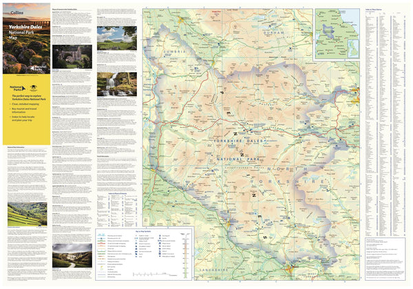
Discover the timeless beauty of Northern England’s most treasured landscapes
Size: 810 mm (W) x 560 mm (H)
Scale: 1:140,000
🏞️ Your Essential Companion to the Yorkshire Dales
Explore the sweeping valleys, limestone cliffs, charming stone-built villages and walking trails of the Yorkshire Dales National Park with this richly detailed map by Collins. Whether you're hiking the Dales Way, photographing windswept moors, or discovering remote waterfalls, this beautifully designed map is your perfect guide to one of Britain’s most beloved natural landscapes.
🔍 Features You'll Love
-
🧭 Clear, easy-to-read cartography with up-to-date roads and park boundaries
-
🏕️ Tourist sites, walking areas, and points of interest clearly marked
-
🏞️ National Park boundary with shaded relief for visual impact
-
📸 Inset photographs showcasing the beauty of the park
-
🚗 Ideal for planning day trips, road journeys, or walking adventures
Whether you're a first-time visitor or a seasoned rambler, this map will help you get the most out of your time in the Dales.
📐 Format Options (Upgrade Available)
We offer this map in a range of high-quality finishes to suit how and where you’ll use or display it:
| Format | Description |
|---|---|
| 📄 Paper (160 gsm) | Printed on heavyweight coated paper. Ideal for framing under glass or pinning to a wall for easy reference. |
| 🧽 Laminated (Encapsulated) | Durable and wipeable with twin 80-micron gloss laminate. Perfect for planning with whiteboard markers or map dots. |
| 🪵 Laminated with Wooden Hang Rails | Elegant and practical—natural timber rails top and bottom with a hanging cord. A ready-to-display format. |
| 🖼️ Canvas (395 gsm HP Matte) | Printed on premium matte canvas using fade-resistant pigment inks. A rich, textured finish perfect for long-term display. |
| 🪵 Canvas with Wooden Hang Rails | The ultimate wall display. Gallery-style timber hang rails give this stunning map a classic yet modern appeal. |
⏳ Please allow up to 10 working days for hang-railed versions as each is hand-mounted by our professional framer.
🎯 Perfect For:
-
Walkers, cyclists, and outdoor enthusiasts
-
Planning unforgettable road trips through the Yorkshire countryside
-
Geography lovers and National Park enthusiasts
-
Decorating holiday cottages, home offices, or camper vans
-
A thoughtful gift for lovers of the British landscape
🌿 See the Dales in a New Light
From the dramatic peaks of Pen-y-ghent and Ingleborough to hidden waterfalls and ancient dry-stone walls, the Yorkshire Dales Map by Collins offers not just navigation—but inspiration. Let this map guide your next journey into the heart of wild Northern England.


